![](/images/other/stat-length.png)
![Excursión Senderismo Édon - La randonnée du château de Larochebeaucourt et de l'arche de la vertue - Photo](https://media.geolcdn.com/t/1900/400/d49471e8-e6c1-4765-8682-f33a419cf277.jpg&format=pjpeg&maxdim=2)
La randonnée du château de Larochebeaucourt et de l'arche de la vertue
alainjoseph6
Usuario
![Longitud](/images/other/stat-length.png)
![Altitud máxima](https://static1.geolcdn.com/siteimages/upload/files/1508320355ic_sort_altitude_max_24dp.png)
![Desnivel positivo](https://static1.geolcdn.com/siteimages/upload/files/1508320355ic_sort_den_pos_24dp.png)
![Km-Effort](/images/other/stat-length.png)
![Altitud mínima](https://static1.geolcdn.com/siteimages/upload/files/1508320355ic_sort_altitude_min_24dp.png)
![Desnivel negativo](https://static1.geolcdn.com/siteimages/upload/files/1508320355ic_sort_den_neg_24dp.png)
![Boucle](https://static1.geolcdn.com/siteimages/upload/files/16400158638029165_repeat_loop_refresh_sync_direction_icon.png)
![Senderismo](https://static1.geolcdn.com/sitytour/trail-icons/101.png)
48m
Dificultad : Fácil
![Escanee este código QR para abrir la excursión en la aplicación SityTrail](https://capi.geolives.com/qq0zvz2zws4bq2lad0pu/sitytour/trails/2753781/qr.png?size=200)
Aplicación GPS de excursión GRATIS
A propósito
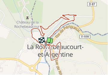
Ruta Senderismo de 2,6 km a descubrir en Nueva Aquitania, Charente, Édon. Esta ruta ha sido propuesta por alainjoseph6.
Descripción
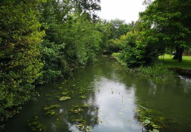
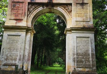
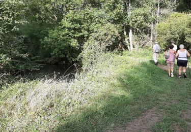
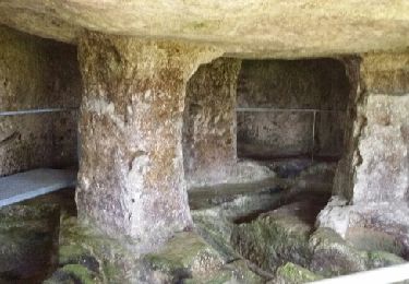
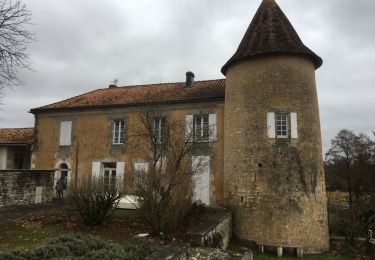
Une super randonnée au départ du parking au bord de la Nizonne , côté Charente vous allez découvrir le château de Larochebeaucourt situé sur la commune de COMBIERS en charente avec le parc du château et son arc de triomphe au bout de l'allée de la vertue.
Ce sentier vous fera découvrir le village de Larochebeaucourt situé de l'autre côté de la rivière Nizonne en Dordogne .Cette petite balade de 2,6 km communique avec les magnifiques sentiers des gardiens du Patrimoine .
Localización
Comentarios
Excursiones cerca
![Excursión Senderismo Combiers - La randonnée de Marchapack - Photo](https://media.geolcdn.com/t/375/260/ea8563e2-4ba2-481a-9ee5-82f48b60f3c1.jpg&format=jpg&maxdim=2)
![Senderismo Senderismo](https://static1.geolcdn.com/sitytour/trail-icons/101.png)
Senderismo
![](/images/other/stat-length.png)
![](https://static1.geolcdn.com/siteimages/upload/files/16400158638029165_repeat_loop_refresh_sync_direction_icon.png)
![Excursión Senderismo La Rochebeaucourt-et-Argentine - Randonnée du 15 août 2022 Les gardiens du Patrimoine - Photo](https://media.geolcdn.com/t/375/260/621c97c7-1f63-4395-9b54-b39175723b89.jpg&format=jpg&maxdim=2)
![Senderismo Senderismo](https://static1.geolcdn.com/sitytour/trail-icons/101.png)
Senderismo
![](/images/other/stat-length.png)
![](https://static1.geolcdn.com/siteimages/upload/files/16400158638029165_repeat_loop_refresh_sync_direction_icon.png)
![Excursión Senderismo Combiers - Rando de Combiers à Larochebeaucourt par chez Maurice - Photo](https://media.geolcdn.com/t/375/260/c6dc3ea3-705e-4acf-bc25-96c5897cc725.jpg&format=jpg&maxdim=2)
![Senderismo Senderismo](https://static1.geolcdn.com/sitytour/trail-icons/101.png)
Senderismo
![](/images/other/stat-length.png)
![](https://static1.geolcdn.com/siteimages/upload/files/16400158638029165_repeat_loop_refresh_sync_direction_icon.png)
![Excursión Senderismo Combiers - Nouveau circuit de randonnée de COMBIERS - balisé jaune - Photo](https://media.geolcdn.com/t/375/260/378fcde2-24d9-47eb-a8d3-f0f1747efca6.jpg&format=jpg&maxdim=2)
![Senderismo Senderismo](https://static1.geolcdn.com/sitytour/trail-icons/101.png)
Senderismo
![](/images/other/stat-length.png)
![](https://static1.geolcdn.com/siteimages/upload/files/16400158638029165_repeat_loop_refresh_sync_direction_icon.png)
![Excursión Senderismo Combiers - De COMBIERS à la grange de l'ONF et retour par les Bernouillies - Photo](https://media.geolcdn.com/t/375/260/ext.jpg?maxdim=2&url=https%3A%2F%2Fservices.sitytrail.com%2FGeolivesWS%2FDownloadMedia.ashx%3FTrailID%3D796168%26Media%3Dfix__20170725090628.jpg)
![Senderismo Senderismo](https://static1.geolcdn.com/sitytour/trail-icons/101.png)
Senderismo
![](/images/other/stat-length.png)
![](https://static1.geolcdn.com/siteimages/upload/files/16400158638029165_repeat_loop_refresh_sync_direction_icon.png)
![Excursión Senderismo Combiers - Le circuit jaune de COMBIERS - Photo](https://media.geolcdn.com/t/375/260/ext.jpg?maxdim=2&url=https%3A%2F%2Fservices.sitytrail.com%2FGeolivesWS%2FDownloadMedia.ashx%3FTrailID%3D613175%26Media%3Dfix__20160812100856.jpg)
![Senderismo Senderismo](https://static1.geolcdn.com/sitytour/trail-icons/101.png)
Senderismo
![](/images/other/stat-length.png)
![](https://static1.geolcdn.com/siteimages/upload/files/16400158638029165_repeat_loop_refresh_sync_direction_icon.png)
![Excursión Senderismo La Rochebeaucourt-et-Argentine - Argentine (24) découverte de ses trésors - Photo](https://media.geolcdn.com/t/375/260/ext.jpg?maxdim=2&url=https%3A%2F%2Fservices.sitytrail.com%2FGeolivesWS%2FDownloadMedia.ashx%3FTrailID%3D314185%26Media%3Dfix__20140619112911.jpg)
![Senderismo Senderismo](https://static1.geolcdn.com/sitytour/trail-icons/101.png)
Senderismo
![](/images/other/stat-length.png)
![](https://static1.geolcdn.com/siteimages/upload/files/16400158638029165_repeat_loop_refresh_sync_direction_icon.png)
![Excursión Senderismo Combiers - rando combiers - Photo](https://media.geolcdn.com/t/375/260/6bfcb907-a727-4148-a353-c6cd8aafdd66.jpg&format=jpg&maxdim=2)
![Senderismo Senderismo](https://static1.geolcdn.com/sitytour/trail-icons/101.png)
Senderismo
![](/images/other/stat-length.png)
![](https://static1.geolcdn.com/siteimages/upload/files/16400158638029165_repeat_loop_refresh_sync_direction_icon.png)
![Excursión Senderismo Blanzaguet-Saint-Cybard - Blanzaguet-Saint-Cybard - Photo](https://media.geolcdn.com/t/375/260/b9b13559-9191-4d57-b6be-7cb97a87ea8f.jpg&format=jpg&maxdim=2)
![Senderismo Senderismo](https://static1.geolcdn.com/sitytour/trail-icons/101.png)
Senderismo
![](/images/other/stat-length.png)
![](https://static1.geolcdn.com/siteimages/upload/files/16400158638029165_repeat_loop_refresh_sync_direction_icon.png)