![](/images/other/stat-length.png)
![Excursión Senderismo Stavelot - Stavelot - 13 ou 18 km - Photo](https://media.geolcdn.com/t/1900/400/d6ddad04-7e1e-4193-9cbc-de76dacfc05c.jpg&format=pjpeg&maxdim=2)
Stavelot - 13 ou 18 km
mumu.larandonneuse
Usuario GUIDE
![Longitud](/images/other/stat-length.png)
![Altitud máxima](https://static1.geolcdn.com/siteimages/upload/files/1508320355ic_sort_altitude_max_24dp.png)
![Desnivel positivo](https://static1.geolcdn.com/siteimages/upload/files/1508320355ic_sort_den_pos_24dp.png)
![Km-Effort](/images/other/stat-length.png)
![Altitud mínima](https://static1.geolcdn.com/siteimages/upload/files/1508320355ic_sort_altitude_min_24dp.png)
![Desnivel negativo](https://static1.geolcdn.com/siteimages/upload/files/1508320355ic_sort_den_neg_24dp.png)
![Boucle](https://static1.geolcdn.com/siteimages/upload/files/16400158638029165_repeat_loop_refresh_sync_direction_icon.png)
![Senderismo](https://static1.geolcdn.com/sitytour/trail-icons/101.png)
3h48
Dificultad : Medio
![Escanee este código QR para abrir la excursión en la aplicación SityTrail](https://capi.geolives.com/qq0zvz2zws4bq2lad0pu/sitytour/trails/2745760/qr.png?size=200)
Aplicación GPS de excursión GRATIS
A propósito
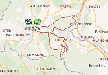
Ruta Senderismo de 17,7 km a descubrir en Valonia, Lieja, Stavelot. Esta ruta ha sido propuesta por mumu.larandonneuse.
Descripción
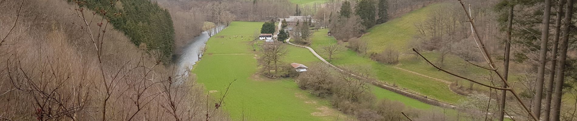
Superbe boucle vallonnée offrant de magnifiques panoramas sur la région.
ℹ Parcours éphémère balisé par le club de Stavelot.
✅ Pour le 13 km, après avoir traversé l'Eau Rouge, à Challes, continuer tout droit le long de l'Amblève alors que le 18 km monte à gauche. Les 2 parcours se rejoignent à la passerelle.
Localización
Comentarios
Excursiones cerca
![Excursión Senderismo Trois-Ponts - RB-Lg-29_Wanne - Photo](https://media.geolcdn.com/t/375/260/ext.jpg?maxdim=2&url=https%3A%2F%2Fservices.sitytrail.com%2FGeolivesWS%2FDownloadMedia.ashx%3FTrailID%3D402097%26Media%3Dd4589c74-2522-4a62-866b-b5d0038bf075.jpg)
![Senderismo Senderismo](https://static1.geolcdn.com/sitytour/trail-icons/101.png)
![Excursión Senderismo Trois-Ponts - RB-Lg-27_Trois-Ponts - Photo](https://media.geolcdn.com/t/375/260/ext.jpg?maxdim=2&url=https%3A%2F%2Fservices.sitytrail.com%2FGeolivesWS%2FDownloadMedia.ashx%3FTrailID%3D402090%26Media%3Ddb9e80d9-8efc-4045-abb6-cee4f6885ea2.jpg)
![Senderismo Senderismo](https://static1.geolcdn.com/sitytour/trail-icons/101.png)
Senderismo
![](/images/other/stat-length.png)
![](https://static1.geolcdn.com/siteimages/upload/files/16400158638029165_repeat_loop_refresh_sync_direction_icon.png)
![Excursión Senderismo Stavelot - 2021-06-30_12h14m27_stavelot_13km_new - Photo](https://media.geolcdn.com/t/375/260/acb4a21b-3ac7-4958-9a44-c1358ae78040.jpg&format=jpg&maxdim=2)
![Senderismo Senderismo](https://static1.geolcdn.com/sitytour/trail-icons/101.png)
Senderismo
![](/images/other/stat-length.png)
![](https://static1.geolcdn.com/siteimages/upload/files/16400158638029165_repeat_loop_refresh_sync_direction_icon.png)
![Excursión Senderismo Stavelot - 2021-03-10_14h59m08_1227 - Photo](https://media.geolcdn.com/t/375/260/8b34c446-55a9-478c-88d7-9cb986b390fb.jpg&format=jpg&maxdim=2)
![Senderismo Senderismo](https://static1.geolcdn.com/sitytour/trail-icons/101.png)
Senderismo
![](/images/other/stat-length.png)
![](https://static1.geolcdn.com/siteimages/upload/files/16400158638029165_repeat_loop_refresh_sync_direction_icon.png)
![Excursión Senderismo Trois-Ponts - RB-Lg-27_Trois-Ponts_via-racc - Photo](https://media.geolcdn.com/t/375/260/ext.jpg?maxdim=2&url=https%3A%2F%2Fservices.sitytrail.com%2FGeolivesWS%2FDownloadMedia.ashx%3FTrailID%3D402091%26Media%3Ddb9e80d9-8efc-4045-abb6-cee4f6885ea2.jpg)
![Senderismo Senderismo](https://static1.geolcdn.com/sitytour/trail-icons/101.png)
Senderismo
![](/images/other/stat-length.png)
![](https://static1.geolcdn.com/siteimages/upload/files/16400158638029165_repeat_loop_refresh_sync_direction_icon.png)
![Excursión Senderismo Stavelot - CHEMIN_DES_SOURCES_Etape_3 - Photo](https://media.geolcdn.com/t/375/260/77791607-24fa-4b91-a259-1d28dbfa8616.jpg&format=jpg&maxdim=2)
![Senderismo Senderismo](https://static1.geolcdn.com/sitytour/trail-icons/101.png)
Senderismo
![](/images/other/stat-length.png)
![](https://static1.geolcdn.com/siteimages/upload/files/16400158638029165_repeat_loop_refresh_sync_direction_icon.png)
![Excursión Ruta Stavelot - Extratrail - Stavelot (red) 23km - Photo](https://media.geolcdn.com/t/375/260/e53e9997-9f75-44d1-82da-8b0ea05ce39d.jpg&format=jpg&maxdim=2)
![Ruta Ruta](https://static1.geolcdn.com/sitytour/trail-icons/104.png)
Ruta
![](/images/other/stat-length.png)
![](https://static1.geolcdn.com/siteimages/upload/files/16400158638029165_repeat_loop_refresh_sync_direction_icon.png)
![Excursión Ruta Stavelot - Extra Trail - Stavelot (blue) 13km - Photo](https://media.geolcdn.com/t/375/260/5430f923-8847-4982-8f77-551b984d4068.jpg&format=jpg&maxdim=2)
![Ruta Ruta](https://static1.geolcdn.com/sitytour/trail-icons/104.png)
Ruta
![](/images/other/stat-length.png)
![](https://static1.geolcdn.com/siteimages/upload/files/16400158638029165_repeat_loop_refresh_sync_direction_icon.png)
![Excursión Ruta Stavelot - Extratrail - Stavelot (green) 9km - Photo](https://media.geolcdn.com/t/375/260/9bfee553-8e48-41c4-b7d0-2265cc8c3fde.jpg&format=jpg&maxdim=2)
![Ruta Ruta](https://static1.geolcdn.com/sitytour/trail-icons/104.png)
Ruta
![](/images/other/stat-length.png)
![](https://static1.geolcdn.com/siteimages/upload/files/16400158638029165_repeat_loop_refresh_sync_direction_icon.png)