![](/images/other/stat-length.png)
![Excursión Senderismo Kasterlee - Lichtaart - Herentals - Photo](https://media.geolcdn.com/t/1900/400/24bf792f-fe8c-4830-86ed-462159e20d6e.jpg&format=pjpeg&maxdim=2)
Lichtaart - Herentals
Bart.Bervoets
Usuario
![Longitud](/images/other/stat-length.png)
Longitud
13,6 km
![Altitud máxima](https://static1.geolcdn.com/siteimages/upload/files/1508320355ic_sort_altitude_max_24dp.png)
Altitud máxima
44 m
![Desnivel positivo](https://static1.geolcdn.com/siteimages/upload/files/1508320355ic_sort_den_pos_24dp.png)
Desnivel positivo
136 m
![Km-Effort](/images/other/stat-length.png)
Km-Effort
15,4 km
![Altitud mínima](https://static1.geolcdn.com/siteimages/upload/files/1508320355ic_sort_altitude_min_24dp.png)
Altitud mínima
9 m
![Desnivel negativo](https://static1.geolcdn.com/siteimages/upload/files/1508320355ic_sort_den_neg_24dp.png)
Desnivel negativo
135 m
![Boucle](https://static1.geolcdn.com/siteimages/upload/files/16400158638029165_repeat_loop_refresh_sync_direction_icon.png)
Boucle
Sí
Fecha de creación :
2021-04-08 15:35:30.435
Última modificación :
2021-04-08 16:49:34.053
![Senderismo](https://static1.geolcdn.com/sitytour/trail-icons/101.png)
3h20
Dificultad : Medio
![Escanee este código QR para abrir la excursión en la aplicación SityTrail](https://capi.geolives.com/qq0zvz2zws4bq2lad0pu/sitytour/trails/2740058/qr.png?size=200)
Aplicación GPS de excursión GRATIS
A propósito
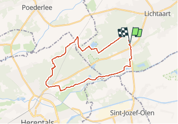
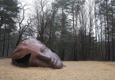
Ruta Senderismo de 13,6 km a descubrir en Flandes, Amberes, Kasterlee. Esta ruta ha sido propuesta por Bart.Bervoets.
Descripción
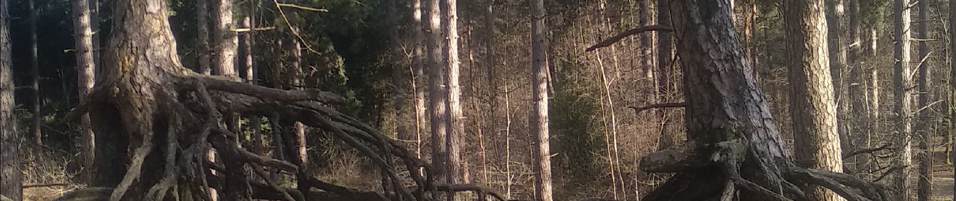
Langs Bobbejaanland parallel met Kleine Nete richting Herentals. Terug via Toeristentoren, het Zwarte Water en Kempense Heuvelrug.
Parking : Camping Floreal
Localización
País:
Belgium
Región :
Flandes
Departamento/provincia :
Amberes
Municipio :
Kasterlee
Localidad:
Lichtaart
Salida:(Dec)
Salida:(UTM)
632764 ; 5675001 (31U) N.
Comentarios
Excursiones cerca
![Excursión Senderismo Herentals - Herentals wandelen tussen groen en monumenten - Photo](https://media.geolcdn.com/t/375/260/ext.jpg?maxdim=2&url=https%3A%2F%2Fstatic1.geolcdn.com%2Fsiteimages%2Fupload%2Ffiles%2F1553511878bg_sport_marche.png)
![Senderismo Senderismo](https://static1.geolcdn.com/sitytour/trail-icons/101.png)
Herentals wandelen tussen groen en monumenten
Senderismo
Medio
(1)
Herentals,
Flandes,
Amberes,
Belgium
![](/images/other/stat-length.png)
7 km | 7,7 km-effort
1h 42min
![](https://static1.geolcdn.com/siteimages/upload/files/16400158638029165_repeat_loop_refresh_sync_direction_icon.png)
Sí
![Excursión Senderismo Kasterlee - Tielen-Turnhout 26 km - Photo](https://media.geolcdn.com/t/375/260/d0911b6b-0746-42bc-a549-7033a371431a.jpg&format=jpg&maxdim=2)
![Senderismo Senderismo](https://static1.geolcdn.com/sitytour/trail-icons/101.png)
Tielen-Turnhout 26 km
Senderismo
Medio
Kasterlee,
Flandes,
Amberes,
Belgium
![](/images/other/stat-length.png)
26 km | 28 km-effort
7h 15min
![](https://static1.geolcdn.com/siteimages/upload/files/16400158638029165_repeat_loop_refresh_sync_direction_icon.png)
No
![Excursión Senderismo Herentals - Herentals 24,7 km - Photo](https://media.geolcdn.com/t/375/260/cfc7a163-3260-42ac-912d-8805f7c5a711.jpg&format=jpg&maxdim=2)
![Senderismo Senderismo](https://static1.geolcdn.com/sitytour/trail-icons/101.png)
Herentals 24,7 km
Senderismo
Medio
Herentals,
Flandes,
Amberes,
Belgium
![](/images/other/stat-length.png)
25 km | 27 km-effort
6h 36min
![](https://static1.geolcdn.com/siteimages/upload/files/16400158638029165_repeat_loop_refresh_sync_direction_icon.png)
Sí
![Excursión Senderismo Kasterlee - En boucle à partir de Goor - Photo](https://media.geolcdn.com/t/375/260/61446ae7-4e03-46ab-95e2-fbeeb563db52.jpg&format=jpg&maxdim=2)
![Senderismo Senderismo](https://static1.geolcdn.com/sitytour/trail-icons/101.png)
En boucle à partir de Goor
Senderismo
Difícil
Kasterlee,
Flandes,
Amberes,
Belgium
![](/images/other/stat-length.png)
25 km | 27 km-effort
6h 28min
![](https://static1.geolcdn.com/siteimages/upload/files/16400158638029165_repeat_loop_refresh_sync_direction_icon.png)
Sí
![Excursión A pie Kasterlee - De Hoge Rielen rode lus - Photo](https://media.geolcdn.com/t/375/260/82fb4373-2a9e-4d8a-9909-a7ae50aef5ce.jpeg&format=jpg&maxdim=2)
![A pie A pie](https://static1.geolcdn.com/sitytour/trail-icons/100.png)
De Hoge Rielen rode lus
A pie
Fácil
Kasterlee,
Flandes,
Amberes,
Belgium
![](/images/other/stat-length.png)
7,9 km | 8,5 km-effort
1h 55min
![](https://static1.geolcdn.com/siteimages/upload/files/16400158638029165_repeat_loop_refresh_sync_direction_icon.png)
Sí
![Excursión Senderismo Kasterlee - 68.509A Kasterlee - Kleine Nete - Photo](https://media.geolcdn.com/t/375/260/d11de9e5-120b-4b11-bafe-ff02dc094674.jpg&format=jpg&maxdim=2)
![Senderismo Senderismo](https://static1.geolcdn.com/sitytour/trail-icons/101.png)
68.509A Kasterlee - Kleine Nete
Senderismo
Medio
(1)
Kasterlee,
Flandes,
Amberes,
Belgium
![](/images/other/stat-length.png)
16,4 km | 17,6 km-effort
4h 53min
![](https://static1.geolcdn.com/siteimages/upload/files/16400158638029165_repeat_loop_refresh_sync_direction_icon.png)
Sí
![Excursión A pie Kasterlee - De Hoge Rielen groene lus - Photo](https://media.geolcdn.com/t/375/260/82fb4373-2a9e-4d8a-9909-a7ae50aef5ce.jpeg&format=jpg&maxdim=2)
![A pie A pie](https://static1.geolcdn.com/sitytour/trail-icons/100.png)
De Hoge Rielen groene lus
A pie
Fácil
Kasterlee,
Flandes,
Amberes,
Belgium
![](/images/other/stat-length.png)
5,2 km | 5,6 km-effort
1h 16min
![](https://static1.geolcdn.com/siteimages/upload/files/16400158638029165_repeat_loop_refresh_sync_direction_icon.png)
Sí
![Excursión Senderismo Kasterlee - Kempense Heuvelrug - Photo](https://media.geolcdn.com/t/375/260/ext.jpg?maxdim=2&url=https%3A%2F%2Fstatic1.geolcdn.com%2Fsiteimages%2Fupload%2Ffiles%2F1553511878bg_sport_marche.png)
![Senderismo Senderismo](https://static1.geolcdn.com/sitytour/trail-icons/101.png)
Kempense Heuvelrug
Senderismo
Muy fácil
Kasterlee,
Flandes,
Amberes,
Belgium
![](/images/other/stat-length.png)
12,4 km | 13,9 km-effort
2h 26min
![](https://static1.geolcdn.com/siteimages/upload/files/16400158638029165_repeat_loop_refresh_sync_direction_icon.png)
Sí
![Excursión Senderismo Herentals - boomshakalaka - Photo](https://media.geolcdn.com/t/375/260/435ec1f1-69cb-48f3-9339-7d4e1723dbb9.jpg&format=jpg&maxdim=2)
![Senderismo Senderismo](https://static1.geolcdn.com/sitytour/trail-icons/101.png)
boomshakalaka
Senderismo
Fácil
Herentals,
Flandes,
Amberes,
Belgium
![](/images/other/stat-length.png)
7 km | 8,1 km-effort
1h 41min
![](https://static1.geolcdn.com/siteimages/upload/files/16400158638029165_repeat_loop_refresh_sync_direction_icon.png)
Sí