![](/images/other/stat-length.png)
![Excursión Senderismo Chidrac - Chidrac à Saint-Floret - Photo](https://media.geolcdn.com/t/1900/400/5da59d21-f425-4820-a1ae-0382394f7a2f.jpg&format=pjpeg&maxdim=2)
Chidrac à Saint-Floret
jome63
Usuario
![Longitud](/images/other/stat-length.png)
![Altitud máxima](https://static1.geolcdn.com/siteimages/upload/files/1508320355ic_sort_altitude_max_24dp.png)
![Desnivel positivo](https://static1.geolcdn.com/siteimages/upload/files/1508320355ic_sort_den_pos_24dp.png)
![Km-Effort](/images/other/stat-length.png)
![Altitud mínima](https://static1.geolcdn.com/siteimages/upload/files/1508320355ic_sort_altitude_min_24dp.png)
![Desnivel negativo](https://static1.geolcdn.com/siteimages/upload/files/1508320355ic_sort_den_neg_24dp.png)
![Boucle](https://static1.geolcdn.com/siteimages/upload/files/16400158638029165_repeat_loop_refresh_sync_direction_icon.png)
![Senderismo](https://static1.geolcdn.com/sitytour/trail-icons/101.png)
2h40
Dificultad : Fácil
![Escanee este código QR para abrir la excursión en la aplicación SityTrail](https://capi.geolives.com/qq0zvz2zws4bq2lad0pu/sitytour/trails/2734748/qr.png?size=200)
Aplicación GPS de excursión GRATIS
A propósito
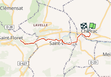
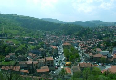
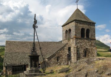
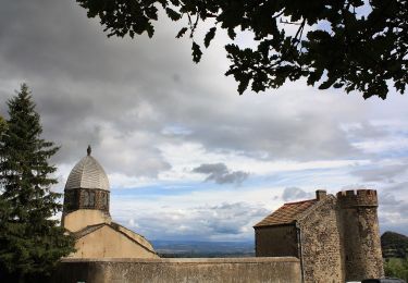
Ruta Senderismo de 8,3 km a descubrir en Auvergne-Rhône-Alpes, Puy-de-Dôme, Chidrac. Esta ruta ha sido propuesta por jome63.
Descripción
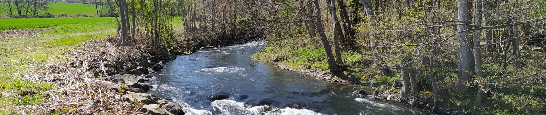
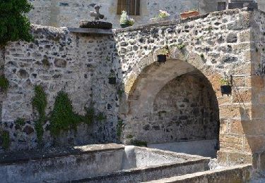
Parcours traversant plusieurs villages, pour ensuite rejoindre un chemin de petite randonnée le long de la Couze Pavin. (ATTENTION une petite partie du chemin à Saint-Vincent est actuellement effondré dans la Couze Pavin. La commune recommande de contourner cette partie par les rues du village.) Départ et retour depuis le parking public rue du Fort à Chidrac.
Localización
Comentarios
Excursiones cerca
![Excursión Senderismo Saint-Vincent - St_Vincent_Puy_Lavelle_JG_02 - Photo](https://media.geolcdn.com/t/375/260/a3fc96ef-efb3-4784-a23c-0f44c0b5ca63.jpg&format=jpg&maxdim=2)
![Senderismo Senderismo](https://static1.geolcdn.com/sitytour/trail-icons/101.png)
Senderismo
![](/images/other/stat-length.png)
![](https://static1.geolcdn.com/siteimages/upload/files/16400158638029165_repeat_loop_refresh_sync_direction_icon.png)
![Excursión Senderismo Champeix - Champeix_St_Julien - Photo](https://media.geolcdn.com/t/375/260/42c319f4-7a47-48dd-bf0b-2587fad533a9.jpg&format=jpg&maxdim=2)
![Senderismo Senderismo](https://static1.geolcdn.com/sitytour/trail-icons/101.png)
Senderismo
![](/images/other/stat-length.png)
![](https://static1.geolcdn.com/siteimages/upload/files/16400158638029165_repeat_loop_refresh_sync_direction_icon.png)
![Excursión A pie Montaigut-le-Blanc - Les caves de Saint-Julien - Photo](https://media.geolcdn.com/t/375/260/cfc5ce46-7f0d-433e-93c8-aa40e374d5a2.jpeg&format=jpg&maxdim=2)
![A pie A pie](https://static1.geolcdn.com/sitytour/trail-icons/100.png)
A pie
![](/images/other/stat-length.png)
![](https://static1.geolcdn.com/siteimages/upload/files/16400158638029165_repeat_loop_refresh_sync_direction_icon.png)
![Excursión A pie Champeix - La Pierre-Fichade - Photo](https://media.geolcdn.com/t/375/260/d1a5f8f1-78ee-45c6-ac5d-3641d548b5c5.jpeg&format=jpg&maxdim=2)
![A pie A pie](https://static1.geolcdn.com/sitytour/trail-icons/100.png)
A pie
![](/images/other/stat-length.png)
![](https://static1.geolcdn.com/siteimages/upload/files/16400158638029165_repeat_loop_refresh_sync_direction_icon.png)
![Excursión A pie Saint-Floret - La Chaubasse - Photo](https://media.geolcdn.com/t/375/260/768fec42-41d9-4005-9393-314a0342ff62.jpeg&format=jpg&maxdim=2)
![A pie A pie](https://static1.geolcdn.com/sitytour/trail-icons/100.png)
A pie
![](/images/other/stat-length.png)
![](https://static1.geolcdn.com/siteimages/upload/files/16400158638029165_repeat_loop_refresh_sync_direction_icon.png)
![Excursión A pie Saint-Floret - Clemensat - Photo](https://media.geolcdn.com/t/375/260/768fec42-41d9-4005-9393-314a0342ff62.jpeg&format=jpg&maxdim=2)
![A pie A pie](https://static1.geolcdn.com/sitytour/trail-icons/100.png)
A pie
![](/images/other/stat-length.png)
![](https://static1.geolcdn.com/siteimages/upload/files/16400158638029165_repeat_loop_refresh_sync_direction_icon.png)
![Excursión A pie Saint-Vincent - Lavelle - Photo](https://media.geolcdn.com/t/375/260/297b1057-563f-4657-92b7-0e66d7544f1c.jpeg&format=jpg&maxdim=2)
![A pie A pie](https://static1.geolcdn.com/sitytour/trail-icons/100.png)
A pie
![](/images/other/stat-length.png)
![](https://static1.geolcdn.com/siteimages/upload/files/16400158638029165_repeat_loop_refresh_sync_direction_icon.png)
![Excursión A pie Montaigut-le-Blanc - Le Puy de la Rodde - Photo](https://media.geolcdn.com/t/375/260/4a1014d7-c9fa-4749-bab6-e03a04c0bb47.jpeg&format=jpg&maxdim=2)
![A pie A pie](https://static1.geolcdn.com/sitytour/trail-icons/100.png)
A pie
![](/images/other/stat-length.png)
![](https://static1.geolcdn.com/siteimages/upload/files/16400158638029165_repeat_loop_refresh_sync_direction_icon.png)
![Excursión A pie Tourzel-Ronzières - Les Cinq Villages - Photo](https://media.geolcdn.com/t/375/260/3398564d-d4fb-4353-84f0-628dcc0a106c.jpeg&format=jpg&maxdim=2)
![A pie A pie](https://static1.geolcdn.com/sitytour/trail-icons/100.png)
A pie
![](/images/other/stat-length.png)
![](https://static1.geolcdn.com/siteimages/upload/files/16400158638029165_repeat_loop_refresh_sync_direction_icon.png)