![](/images/other/stat-length.png)
![Excursión Senderismo Loire-sur-Rhône - Amicale_Loire_sur_Rhone_Burlat - Photo](https://media.geolcdn.com/t/1900/400/ext.pjpeg?maxdim=2&url=https%3A%2F%2Fstatic1.geolcdn.com%2Fsiteimages%2Fupload%2Ffiles%2F1553511878bg_sport_marche.png)
Amicale_Loire_sur_Rhone_Burlat
d.rognon
Usuario
![Longitud](/images/other/stat-length.png)
Longitud
15,9 km
![Altitud máxima](https://static1.geolcdn.com/siteimages/upload/files/1508320355ic_sort_altitude_max_24dp.png)
Altitud máxima
486 m
![Desnivel positivo](https://static1.geolcdn.com/siteimages/upload/files/1508320355ic_sort_den_pos_24dp.png)
Desnivel positivo
478 m
![Km-Effort](/images/other/stat-length.png)
Km-Effort
22 km
![Altitud mínima](https://static1.geolcdn.com/siteimages/upload/files/1508320355ic_sort_altitude_min_24dp.png)
Altitud mínima
160 m
![Desnivel negativo](https://static1.geolcdn.com/siteimages/upload/files/1508320355ic_sort_den_neg_24dp.png)
Desnivel negativo
483 m
![Boucle](https://static1.geolcdn.com/siteimages/upload/files/16400158638029165_repeat_loop_refresh_sync_direction_icon.png)
Boucle
Sí
Fecha de creación :
2021-03-31 09:03:25.076
Última modificación :
2021-06-24 02:41:45.441
![Senderismo](https://static1.geolcdn.com/sitytour/trail-icons/101.png)
5h03
Dificultad : Muy difícil
![Escanee este código QR para abrir la excursión en la aplicación SityTrail](https://capi.geolives.com/qq0zvz2zws4bq2lad0pu/sitytour/trails/2729111/qr.png?size=200)
Aplicación GPS de excursión GRATIS
A propósito
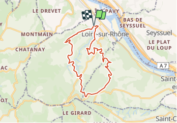
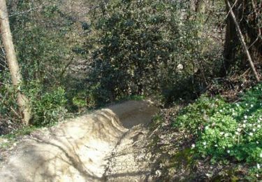
Ruta Senderismo de 15,9 km a descubrir en Auvergne-Rhône-Alpes, Ródano, Loire-sur-Rhône. Esta ruta ha sido propuesta por d.rognon.
Descripción
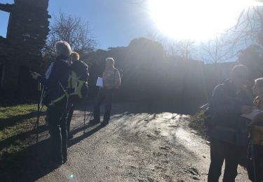
Randonnée effectuée le 20/06/21.
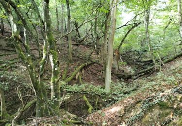
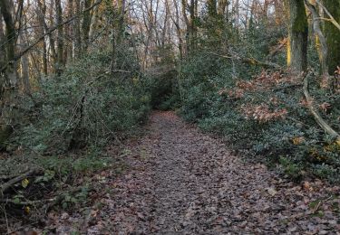
Beaucoup de trajet en sous-bois, ce qui est agréable lors des grosses chaleurs.
Localización
País:
France
Región :
Auvergne-Rhône-Alpes
Departamento/provincia :
Ródano
Municipio :
Loire-sur-Rhône
Localidad:
Unknown
Salida:(Dec)
Salida:(UTM)
640366 ; 5047044 (31T) N.
Comentarios
Excursiones cerca
![Excursión Senderismo Loire-sur-Rhône - 42 le grisard (vienne) - Photo](https://media.geolcdn.com/t/375/260/c8c552c2-c833-47f9-98c4-fadea207952f.jpg&format=jpg&maxdim=2)
![Senderismo Senderismo](https://static1.geolcdn.com/sitytour/trail-icons/101.png)
42 le grisard (vienne)
Senderismo
Muy fácil
Loire-sur-Rhône,
Auvergne-Rhône-Alpes,
Ródano,
France
![](/images/other/stat-length.png)
5,6 km | 8,2 km-effort
2h 8min
![](https://static1.geolcdn.com/siteimages/upload/files/16400158638029165_repeat_loop_refresh_sync_direction_icon.png)
Sí
![Excursión Senderismo Saint-Romain-en-Gal - le grisard - Photo](https://media.geolcdn.com/t/375/260/ext.jpg?maxdim=2&url=https%3A%2F%2Fstatic1.geolcdn.com%2Fsiteimages%2Fupload%2Ffiles%2F1553511878bg_sport_marche.png)
![Senderismo Senderismo](https://static1.geolcdn.com/sitytour/trail-icons/101.png)
le grisard
Senderismo
Medio
(1)
Saint-Romain-en-Gal,
Auvergne-Rhône-Alpes,
Ródano,
France
![](/images/other/stat-length.png)
5,3 km | 7,9 km-effort
1h 48min
![](https://static1.geolcdn.com/siteimages/upload/files/16400158638029165_repeat_loop_refresh_sync_direction_icon.png)
Sí
![Excursión Senderismo Loire-sur-Rhône - 69-loire-sur-rhone2-pet-de-loup-18km-560m - Photo](https://media.geolcdn.com/t/375/260/ee6f14b8-8ed9-4a30-84a4-6a7d5babc72f.jpg&format=jpg&maxdim=2)
![Senderismo Senderismo](https://static1.geolcdn.com/sitytour/trail-icons/101.png)
69-loire-sur-rhone2-pet-de-loup-18km-560m
Senderismo
Medio
(1)
Loire-sur-Rhône,
Auvergne-Rhône-Alpes,
Ródano,
France
![](/images/other/stat-length.png)
17,7 km | 25 km-effort
3h 3min
![](https://static1.geolcdn.com/siteimages/upload/files/16400158638029165_repeat_loop_refresh_sync_direction_icon.png)
Sí
![Excursión Senderismo Loire-sur-Rhône - 69-Loire-sur-Rhone-17km-480m-avr22 - Photo](https://media.geolcdn.com/t/375/260/13a86102-41dd-4011-b432-58d1cdb1bc2f.jpg&format=jpg&maxdim=2)
![Senderismo Senderismo](https://static1.geolcdn.com/sitytour/trail-icons/101.png)
69-Loire-sur-Rhone-17km-480m-avr22
Senderismo
Medio
Loire-sur-Rhône,
Auvergne-Rhône-Alpes,
Ródano,
France
![](/images/other/stat-length.png)
16,7 km | 23 km-effort
5h 9min
![](https://static1.geolcdn.com/siteimages/upload/files/16400158638029165_repeat_loop_refresh_sync_direction_icon.png)
Sí
![Excursión Senderismo Communay - balade notre dame de linon - Photo](https://media.geolcdn.com/t/375/260/40fdd5d2-5497-40a2-be42-86d136965eda.jpg&format=jpg&maxdim=2)
![Senderismo Senderismo](https://static1.geolcdn.com/sitytour/trail-icons/101.png)
balade notre dame de linon
Senderismo
Fácil
Communay,
Auvergne-Rhône-Alpes,
Ródano,
France
![](/images/other/stat-length.png)
4,9 km | 7,2 km-effort
2h 7min
![](https://static1.geolcdn.com/siteimages/upload/files/16400158638029165_repeat_loop_refresh_sync_direction_icon.png)
Sí
![Excursión Senderismo Loire-sur-Rhône - St romain x - Photo](https://media.geolcdn.com/t/375/260/358b915a-eb20-4dde-b906-3f49a51f6028.jpg&format=jpg&maxdim=2)
![Senderismo Senderismo](https://static1.geolcdn.com/sitytour/trail-icons/101.png)
St romain x
Senderismo
Loire-sur-Rhône,
Auvergne-Rhône-Alpes,
Ródano,
France
![](/images/other/stat-length.png)
3,6 km | 5 km-effort
1h 57min
![](https://static1.geolcdn.com/siteimages/upload/files/16400158638029165_repeat_loop_refresh_sync_direction_icon.png)
No
![Excursión Bici de montaña Chasse-sur-Rhône - Chasse-Chuzelles-Villette - Photo](https://media.geolcdn.com/t/375/260/ext.jpg?maxdim=2&url=https%3A%2F%2Fservices.sitytrail.com%2FGeolivesWS%2FDownloadMedia.ashx%3FTrailID%3D101365%26Media%3D1048_2.jpg)
![Bici de montaña Bici de montaña](https://static1.geolcdn.com/sitytour/trail-icons/202.png)
Chasse-Chuzelles-Villette
Bici de montaña
Difícil
Chasse-sur-Rhône,
Auvergne-Rhône-Alpes,
Isère,
France
![](/images/other/stat-length.png)
38 km | 49 km-effort
3h 0min
![](https://static1.geolcdn.com/siteimages/upload/files/16400158638029165_repeat_loop_refresh_sync_direction_icon.png)
Sí
![Excursión Coche Simandres - corbas 47 67 - Photo](https://media.geolcdn.com/t/375/260/ext.jpg?maxdim=2&url=https%3A%2F%2Fstatic1.geolcdn.com%2Fsiteimages%2Fupload%2Ffiles%2F15247431544x4.jpg)
![Coche Coche](https://static1.geolcdn.com/sitytour/trail-icons/401.png)
corbas 47 67
Coche
Muy fácil
Simandres,
Auvergne-Rhône-Alpes,
Ródano,
France
![](/images/other/stat-length.png)
15,6 km | 17,1 km-effort
1h 0min
![](https://static1.geolcdn.com/siteimages/upload/files/16400158638029165_repeat_loop_refresh_sync_direction_icon.png)
No
![Excursión Senderismo Beauvallon - chassagny2023 - Photo](https://media.geolcdn.com/t/375/260/ext.jpg?maxdim=2&url=https%3A%2F%2Fstatic1.geolcdn.com%2Fsiteimages%2Fupload%2Ffiles%2F1553511878bg_sport_marche.png)
![Senderismo Senderismo](https://static1.geolcdn.com/sitytour/trail-icons/101.png)
chassagny2023
Senderismo
Medio
Beauvallon,
Auvergne-Rhône-Alpes,
Ródano,
France
![](/images/other/stat-length.png)
7,8 km | 10 km-effort
2h 53min
![](https://static1.geolcdn.com/siteimages/upload/files/16400158638029165_repeat_loop_refresh_sync_direction_icon.png)
No