![](/images/other/stat-length.png)
![Excursión Senderismo Annot - Croix de Braux Variante Marc - Photo](https://media.geolcdn.com/t/1900/400/ext.pjpeg?maxdim=2&url=https%3A%2F%2Fstatic1.geolcdn.com%2Fsiteimages%2Fupload%2Ffiles%2F1553511878bg_sport_marche.png)
Croix de Braux Variante Marc
dan0406
Usuario
![Longitud](/images/other/stat-length.png)
Longitud
11,5 km
![Altitud máxima](https://static1.geolcdn.com/siteimages/upload/files/1508320355ic_sort_altitude_max_24dp.png)
Altitud máxima
1353 m
![Desnivel positivo](https://static1.geolcdn.com/siteimages/upload/files/1508320355ic_sort_den_pos_24dp.png)
Desnivel positivo
739 m
![Km-Effort](/images/other/stat-length.png)
Km-Effort
21 km
![Altitud mínima](https://static1.geolcdn.com/siteimages/upload/files/1508320355ic_sort_altitude_min_24dp.png)
Altitud mínima
704 m
![Desnivel negativo](https://static1.geolcdn.com/siteimages/upload/files/1508320355ic_sort_den_neg_24dp.png)
Desnivel negativo
739 m
![Boucle](https://static1.geolcdn.com/siteimages/upload/files/16400158638029165_repeat_loop_refresh_sync_direction_icon.png)
Boucle
Sí
Fecha de creación :
2021-03-27 07:33:00.897
Última modificación :
2021-03-27 07:35:07.957
![Senderismo](https://static1.geolcdn.com/sitytour/trail-icons/101.png)
4h50
Dificultad : Muy difícil
![Escanee este código QR para abrir la excursión en la aplicación SityTrail](https://capi.geolives.com/qq0zvz2zws4bq2lad0pu/sitytour/trails/2722726/qr.png?size=200)
Aplicación GPS de excursión GRATIS
A propósito
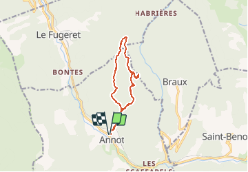
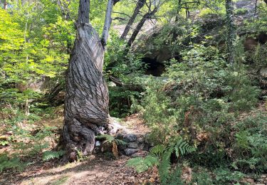
Ruta Senderismo de 11,5 km a descubrir en Provenza-Alpes-Costa Azul, Alpes de Alta Provenza, Annot. Esta ruta ha sido propuesta por dan0406.
Descripción
La longueur de l'itinéraire est 11,7km, la dénivelée 850m, elle est qualifiée "très difficile"
Localización
País:
France
Región :
Provenza-Alpes-Costa Azul
Departamento/provincia :
Alpes de Alta Provenza
Municipio :
Annot
Localidad:
Unknown
Salida:(Dec)
Salida:(UTM)
312809 ; 4870983 (32T) N.
Comentarios
Excursiones cerca
![Excursión A pie Annot - Le Grès d'Annot - Photo](https://media.geolcdn.com/t/375/260/d494c9f4-04f5-4184-be97-f5fea23e1191.jpeg&format=jpg&maxdim=2)
![A pie A pie](https://static1.geolcdn.com/sitytour/trail-icons/100.png)
Le Grès d'Annot
A pie
Fácil
Annot,
Provenza-Alpes-Costa Azul,
Alpes de Alta Provenza,
France
![](/images/other/stat-length.png)
5,9 km | 10,9 km-effort
2h 28min
![](https://static1.geolcdn.com/siteimages/upload/files/16400158638029165_repeat_loop_refresh_sync_direction_icon.png)
Sí
![Excursión Senderismo Annot - J4 Annot - Photo](https://media.geolcdn.com/t/375/260/be9d9d12-b8a6-45a8-bd70-6f8cacf32730.jpg&format=jpg&maxdim=2)
![Senderismo Senderismo](https://static1.geolcdn.com/sitytour/trail-icons/101.png)
J4 Annot
Senderismo
Medio
Annot,
Provenza-Alpes-Costa Azul,
Alpes de Alta Provenza,
France
![](/images/other/stat-length.png)
6,2 km | 11,3 km-effort
2h 34min
![](https://static1.geolcdn.com/siteimages/upload/files/16400158638029165_repeat_loop_refresh_sync_direction_icon.png)
Sí
![Senderismo Senderismo](https://static1.geolcdn.com/sitytour/trail-icons/101.png)
Les Grès d'Annot
Senderismo
Medio
Annot,
Provenza-Alpes-Costa Azul,
Alpes de Alta Provenza,
France
![](/images/other/stat-length.png)
5,8 km | 10,8 km-effort
2h 9min
![](https://static1.geolcdn.com/siteimages/upload/files/16400158638029165_repeat_loop_refresh_sync_direction_icon.png)
Sí
![Excursión Senderismo Annot - Rando gastro Roncharel - Photo](https://media.geolcdn.com/t/375/260/4e3f8487-9887-4ec3-94b2-d5bbd50aefe8.jpg&format=jpg&maxdim=2)
![Senderismo Senderismo](https://static1.geolcdn.com/sitytour/trail-icons/101.png)
Rando gastro Roncharel
Senderismo
Medio
Annot,
Provenza-Alpes-Costa Azul,
Alpes de Alta Provenza,
France
![](/images/other/stat-length.png)
5,8 km | 11,9 km-effort
2h 42min
![](https://static1.geolcdn.com/siteimages/upload/files/16400158638029165_repeat_loop_refresh_sync_direction_icon.png)
No
![Excursión Senderismo Annot - Les grès d'Annot - Photo](https://media.geolcdn.com/t/375/260/ext.jpg?maxdim=2&url=https%3A%2F%2Fstatic1.geolcdn.com%2Fsiteimages%2Fupload%2Ffiles%2F1553511878bg_sport_marche.png)
![Senderismo Senderismo](https://static1.geolcdn.com/sitytour/trail-icons/101.png)
Les grès d'Annot
Senderismo
Medio
(1)
Annot,
Provenza-Alpes-Costa Azul,
Alpes de Alta Provenza,
France
![](/images/other/stat-length.png)
11,5 km | 19,2 km-effort
6h 2min
![](https://static1.geolcdn.com/siteimages/upload/files/16400158638029165_repeat_loop_refresh_sync_direction_icon.png)
Sí
![Excursión Senderismo Annot - Rando bleue - Photo](https://media.geolcdn.com/t/375/260/94ab7e9b-3b20-4840-b15c-d5a4c12ad390.jpg&format=jpg&maxdim=2)
![Senderismo Senderismo](https://static1.geolcdn.com/sitytour/trail-icons/101.png)
Rando bleue
Senderismo
Fácil
Annot,
Provenza-Alpes-Costa Azul,
Alpes de Alta Provenza,
France
![](/images/other/stat-length.png)
3,9 km | 5,8 km-effort
1h 22min
![](https://static1.geolcdn.com/siteimages/upload/files/16400158638029165_repeat_loop_refresh_sync_direction_icon.png)
Sí
![Excursión Senderismo Braux - Rando Pieŕre qui tremble Chabrieres Peloussis Argenton - Photo](https://media.geolcdn.com/t/375/260/cfc0cc00-9a69-459b-9e00-f152d8d54736.jpg&format=jpg&maxdim=2)
![Senderismo Senderismo](https://static1.geolcdn.com/sitytour/trail-icons/101.png)
Rando Pieŕre qui tremble Chabrieres Peloussis Argenton
Senderismo
Medio
Braux,
Provenza-Alpes-Costa Azul,
Alpes de Alta Provenza,
France
![](/images/other/stat-length.png)
14 km | 22 km-effort
6h 27min
![](https://static1.geolcdn.com/siteimages/upload/files/16400158638029165_repeat_loop_refresh_sync_direction_icon.png)
Sí
![Excursión Senderismo Annot - Grès d'Annot Carte IGN 3541OT - Photo](https://media.geolcdn.com/t/375/260/9f9453a3-f8fb-41f4-87f9-67579e26dbf0.jpg&format=jpg&maxdim=2)
![Senderismo Senderismo](https://static1.geolcdn.com/sitytour/trail-icons/101.png)
Grès d'Annot Carte IGN 3541OT
Senderismo
Medio
Annot,
Provenza-Alpes-Costa Azul,
Alpes de Alta Provenza,
France
![](/images/other/stat-length.png)
11,3 km | 21 km-effort
7h 23min
![](https://static1.geolcdn.com/siteimages/upload/files/16400158638029165_repeat_loop_refresh_sync_direction_icon.png)
Sí
![Excursión Senderismo Annot - Les grès d'Annot-20-05-22 - Photo](https://media.geolcdn.com/t/375/260/3872c580-3dd5-4977-8057-6ad4a77228f8.jpg&format=jpg&maxdim=2)
![Senderismo Senderismo](https://static1.geolcdn.com/sitytour/trail-icons/101.png)
Les grès d'Annot-20-05-22
Senderismo
Medio
Annot,
Provenza-Alpes-Costa Azul,
Alpes de Alta Provenza,
France
![](/images/other/stat-length.png)
6,8 km | 12,4 km-effort
2h 20min
![](https://static1.geolcdn.com/siteimages/upload/files/16400158638029165_repeat_loop_refresh_sync_direction_icon.png)
No