![](/images/other/stat-length.png)
![Excursión Ruta Sainte-Catherine - Ste Catherine - 9,4 km - 293 m de dénivelé - 3h - Photo](https://media.geolcdn.com/t/1900/400/ext.pjpeg?maxdim=2&url=https%3A%2F%2Fstatic1.geolcdn.com%2Fsiteimages%2Fupload%2Ffiles%2F1524743154running.jpg)
Ste Catherine - 9,4 km - 293 m de dénivelé - 3h
Clubléorando
Usuario
![Longitud](/images/other/stat-length.png)
Longitud
9,4 km
![Altitud máxima](https://static1.geolcdn.com/siteimages/upload/files/1508320355ic_sort_altitude_max_24dp.png)
Altitud máxima
865 m
![Desnivel positivo](https://static1.geolcdn.com/siteimages/upload/files/1508320355ic_sort_den_pos_24dp.png)
Desnivel positivo
293 m
![Km-Effort](/images/other/stat-length.png)
Km-Effort
13,3 km
![Altitud mínima](https://static1.geolcdn.com/siteimages/upload/files/1508320355ic_sort_altitude_min_24dp.png)
Altitud mínima
682 m
![Desnivel negativo](https://static1.geolcdn.com/siteimages/upload/files/1508320355ic_sort_den_neg_24dp.png)
Desnivel negativo
293 m
![Boucle](https://static1.geolcdn.com/siteimages/upload/files/16400158638029165_repeat_loop_refresh_sync_direction_icon.png)
Boucle
Sí
Fecha de creación :
2021-03-23 09:05:41.102
Última modificación :
2021-03-23 09:10:45.671
![Ruta](https://static1.geolcdn.com/sitytour/trail-icons/104.png)
3h00
Dificultad : Medio
![Escanee este código QR para abrir la excursión en la aplicación SityTrail](https://capi.geolives.com/qq0zvz2zws4bq2lad0pu/sitytour/trails/2717885/qr.png?size=200)
Aplicación GPS de excursión GRATIS
A propósito
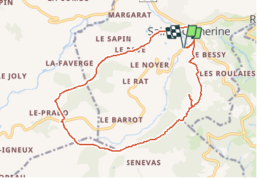
Ruta Ruta de 9,4 km a descubrir en Auvergne-Rhône-Alpes, Ródano, Sainte-Catherine. Esta ruta ha sido propuesta por Clubléorando.
Descripción
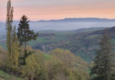
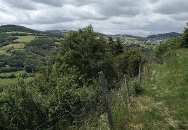
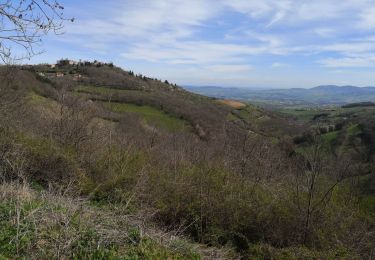
Belle ballade en boucle au départ de Ste Catherine puis montée sur les hauteurs des monts du Lyonnais en allant au point de vue de la croix du Châtelard et retour en traversant le bois des Feuilles
Localización
País:
France
Región :
Auvergne-Rhône-Alpes
Departamento/provincia :
Ródano
Municipio :
Sainte-Catherine
Localidad:
Unknown
Salida:(Dec)
Salida:(UTM)
622343 ; 5050346 (31T) N.
Comentarios
Excursiones cerca
![Excursión Senderismo Sainte-Catherine - ste Catherine le Signal St André - Photo](https://media.geolcdn.com/t/375/260/ext.jpg?maxdim=2&url=https%3A%2F%2Fstatic1.geolcdn.com%2Fsiteimages%2Fupload%2Ffiles%2F1553511878bg_sport_marche.png)
![Senderismo Senderismo](https://static1.geolcdn.com/sitytour/trail-icons/101.png)
ste Catherine le Signal St André
Senderismo
Muy difícil
(1)
Sainte-Catherine,
Auvergne-Rhône-Alpes,
Ródano,
France
![](/images/other/stat-length.png)
16,8 km | 24 km-effort
5h 27min
![](https://static1.geolcdn.com/siteimages/upload/files/16400158638029165_repeat_loop_refresh_sync_direction_icon.png)
Sí
![Excursión Senderismo Saint-Joseph - 42-st-joseph-10km-320m - Photo](https://media.geolcdn.com/t/375/260/d6018596-5a38-4194-9525-041abab6ce05.jpg&format=jpg&maxdim=2)
![Senderismo Senderismo](https://static1.geolcdn.com/sitytour/trail-icons/101.png)
42-st-joseph-10km-320m
Senderismo
Fácil
Saint-Joseph,
Auvergne-Rhône-Alpes,
Loira,
France
![](/images/other/stat-length.png)
10,5 km | 14,8 km-effort
2h 50min
![](https://static1.geolcdn.com/siteimages/upload/files/16400158638029165_repeat_loop_refresh_sync_direction_icon.png)
Sí
![Excursión Senderismo Chabanière - 69-st-maurice-dargoire2-19km-580m - Photo](https://media.geolcdn.com/t/375/260/c4b20fd4-ad58-4836-9971-2020b70efe6f.jpg&format=jpg&maxdim=2)
![Senderismo Senderismo](https://static1.geolcdn.com/sitytour/trail-icons/101.png)
69-st-maurice-dargoire2-19km-580m
Senderismo
Difícil
Chabanière,
Auvergne-Rhône-Alpes,
Ródano,
France
![](/images/other/stat-length.png)
19,2 km | 27 km-effort
5h 47min
![](https://static1.geolcdn.com/siteimages/upload/files/16400158638029165_repeat_loop_refresh_sync_direction_icon.png)
Sí
![Excursión Senderismo Saint-Martin-la-Plaine - 42-martinlaplaine-12km450m - Photo](https://media.geolcdn.com/t/375/260/0bbcbe3d-ff1f-4c48-95ef-874625509cfa.jpg&format=jpg&maxdim=2)
![Senderismo Senderismo](https://static1.geolcdn.com/sitytour/trail-icons/101.png)
42-martinlaplaine-12km450m
Senderismo
Difícil
Saint-Martin-la-Plaine,
Auvergne-Rhône-Alpes,
Loira,
France
![](/images/other/stat-length.png)
12,9 km | 18,9 km-effort
4h 17min
![](https://static1.geolcdn.com/siteimages/upload/files/16400158638029165_repeat_loop_refresh_sync_direction_icon.png)
Sí
![Excursión Senderismo Riverie - Riverie - Tour au dessus de Riverie - Photo](https://media.geolcdn.com/t/375/260/f386fa9b-109a-4f00-b8bc-6419b37fffdc.jpg&format=jpg&maxdim=2)
![Senderismo Senderismo](https://static1.geolcdn.com/sitytour/trail-icons/101.png)
Riverie - Tour au dessus de Riverie
Senderismo
Medio
Riverie,
Auvergne-Rhône-Alpes,
Ródano,
France
![](/images/other/stat-length.png)
5,7 km | 7,8 km-effort
2h 4min
![](https://static1.geolcdn.com/siteimages/upload/files/16400158638029165_repeat_loop_refresh_sync_direction_icon.png)
Sí
![Excursión Senderismo Saint-André-la-Côte - 69-st-andre-la cote-mattiole-20km-640m-mai22 - Photo](https://media.geolcdn.com/t/375/260/7a464e9e-07ad-49d2-9fc0-eab7bce1d3e5.jpg&format=jpg&maxdim=2)
![Senderismo Senderismo](https://static1.geolcdn.com/sitytour/trail-icons/101.png)
69-st-andre-la cote-mattiole-20km-640m-mai22
Senderismo
Medio
Saint-André-la-Côte,
Auvergne-Rhône-Alpes,
Ródano,
France
![](/images/other/stat-length.png)
20 km | 29 km-effort
5h 56min
![](https://static1.geolcdn.com/siteimages/upload/files/16400158638029165_repeat_loop_refresh_sync_direction_icon.png)
Sí
![Excursión Senderismo Saint-André-la-Côte - 69-St-andre-la-cote-Ste-catherine-14km-453m - Photo](https://media.geolcdn.com/t/375/260/06cb0992-8e16-4e77-b851-837722622855.jpg&format=jpg&maxdim=2)
![Senderismo Senderismo](https://static1.geolcdn.com/sitytour/trail-icons/101.png)
69-St-andre-la-cote-Ste-catherine-14km-453m
Senderismo
Medio
Saint-André-la-Côte,
Auvergne-Rhône-Alpes,
Ródano,
France
![](/images/other/stat-length.png)
14,2 km | 20 km-effort
3h 48min
![](https://static1.geolcdn.com/siteimages/upload/files/16400158638029165_repeat_loop_refresh_sync_direction_icon.png)
Sí
![Excursión Senderismo Riverie - Tour de Riverie - Photo](https://media.geolcdn.com/t/375/260/921cac9b-3a26-4e9e-996b-090d375df192.jpg&format=jpg&maxdim=2)
![Senderismo Senderismo](https://static1.geolcdn.com/sitytour/trail-icons/101.png)
Tour de Riverie
Senderismo
Muy fácil
Riverie,
Auvergne-Rhône-Alpes,
Ródano,
France
![](/images/other/stat-length.png)
5,5 km | 8,2 km-effort
3h 1min
![](https://static1.geolcdn.com/siteimages/upload/files/16400158638029165_repeat_loop_refresh_sync_direction_icon.png)
Sí
![Excursión Senderismo Riverie - De Riverie à Sainte Catherine - Photo](https://media.geolcdn.com/t/375/260/c7a98120-57a9-4a3e-a51c-d75d0931a5ce.jpg&format=jpg&maxdim=2)
![Senderismo Senderismo](https://static1.geolcdn.com/sitytour/trail-icons/101.png)
De Riverie à Sainte Catherine
Senderismo
Fácil
Riverie,
Auvergne-Rhône-Alpes,
Ródano,
France
![](/images/other/stat-length.png)
6,3 km | 9,2 km-effort
4h 5min
![](https://static1.geolcdn.com/siteimages/upload/files/16400158638029165_repeat_loop_refresh_sync_direction_icon.png)
Sí