![](/images/other/stat-length.png)
![Excursión Senderismo Aups - AUPS - GROTTES ET CHAPELLES - Photo](https://media.geolcdn.com/t/1900/400/ffc0fac0-d36b-49b3-8114-499090cbd5ce.jpg&format=pjpeg&maxdim=2)
AUPS - GROTTES ET CHAPELLES
jean-marie.parachini
Usuario
![Longitud](/images/other/stat-length.png)
Longitud
11,6 km
![Altitud máxima](https://static1.geolcdn.com/siteimages/upload/files/1508320355ic_sort_altitude_max_24dp.png)
Altitud máxima
664 m
![Desnivel positivo](https://static1.geolcdn.com/siteimages/upload/files/1508320355ic_sort_den_pos_24dp.png)
Desnivel positivo
368 m
![Km-Effort](/images/other/stat-length.png)
Km-Effort
16,5 km
![Altitud mínima](https://static1.geolcdn.com/siteimages/upload/files/1508320355ic_sort_altitude_min_24dp.png)
Altitud mínima
485 m
![Desnivel negativo](https://static1.geolcdn.com/siteimages/upload/files/1508320355ic_sort_den_neg_24dp.png)
Desnivel negativo
368 m
![Boucle](https://static1.geolcdn.com/siteimages/upload/files/16400158638029165_repeat_loop_refresh_sync_direction_icon.png)
Boucle
Sí
Fecha de creación :
2021-03-21 08:52:00.745
Última modificación :
2021-03-21 17:23:16.07
![Senderismo](https://static1.geolcdn.com/sitytour/trail-icons/101.png)
4h55
Dificultad : Fácil
![Escanee este código QR para abrir la excursión en la aplicación SityTrail](https://capi.geolives.com/qq0zvz2zws4bq2lad0pu/sitytour/trails/2716181/qr.png?size=200)
Aplicación GPS de excursión GRATIS
A propósito
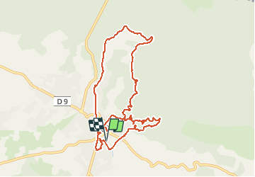
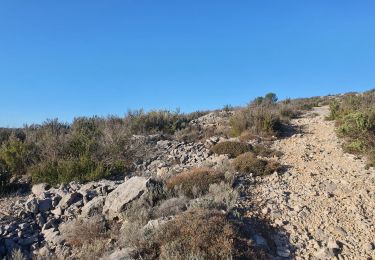
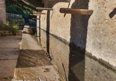
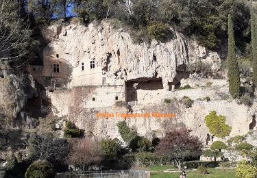
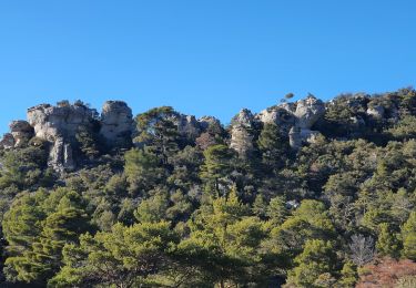
Ruta Senderismo de 11,6 km a descubrir en Provenza-Alpes-Costa Azul, Var, Aups. Esta ruta ha sido propuesta por jean-marie.parachini.
Descripción
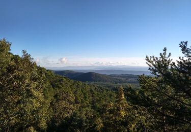
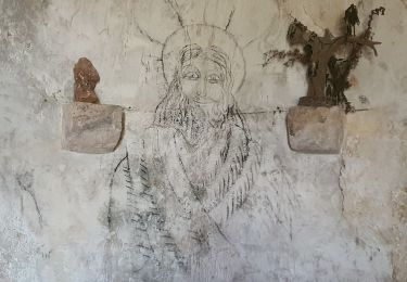
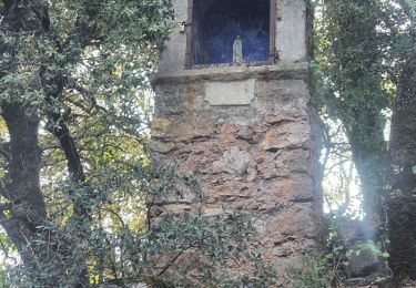
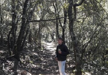
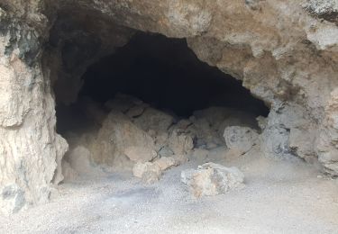
randonnée autour d'Aups avec grottes et anciennes chapelles sur le parcours.
Localización
País:
France
Región :
Provenza-Alpes-Costa Azul
Departamento/provincia :
Var
Municipio :
Aups
Localidad:
Unknown
Salida:(Dec)
Salida:(UTM)
276187 ; 4834083 (32T) N.
Comentarios
Excursiones cerca
![Excursión Senderismo Aups - Tour de la montagne des Espiguières - Photo](https://media.geolcdn.com/t/375/260/431b4009-bb72-41ce-bf82-1eb70c111177.jpg&format=jpg&maxdim=2)
![Senderismo Senderismo](https://static1.geolcdn.com/sitytour/trail-icons/101.png)
Tour de la montagne des Espiguières
Senderismo
Difícil
(1)
Aups,
Provenza-Alpes-Costa Azul,
Var,
France
![](/images/other/stat-length.png)
11 km | 15,4 km-effort
3h 30min
![](https://static1.geolcdn.com/siteimages/upload/files/16400158638029165_repeat_loop_refresh_sync_direction_icon.png)
Sí
![Excursión Senderismo Vérignon - 2024-01-30 Vérignon - Chapelle Saint Priest - Photo](https://media.geolcdn.com/t/375/260/bc33279d-e419-4c1d-b671-4cabd4fbe480.jpg&format=jpg&maxdim=2)
![Senderismo Senderismo](https://static1.geolcdn.com/sitytour/trail-icons/101.png)
2024-01-30 Vérignon - Chapelle Saint Priest
Senderismo
Difícil
Vérignon,
Provenza-Alpes-Costa Azul,
Var,
France
![](/images/other/stat-length.png)
10,5 km | 14,6 km-effort
3h 19min
![](https://static1.geolcdn.com/siteimages/upload/files/16400158638029165_repeat_loop_refresh_sync_direction_icon.png)
Sí
![Excursión Senderismo Salernes - 2024-01-23 Salernes - Saint Barthélémy - Photo](https://media.geolcdn.com/t/375/260/cc5df783-866a-4bd9-89b4-172fc6b32819.jpg&format=jpg&maxdim=2)
![Senderismo Senderismo](https://static1.geolcdn.com/sitytour/trail-icons/101.png)
2024-01-23 Salernes - Saint Barthélémy
Senderismo
Difícil
Salernes,
Provenza-Alpes-Costa Azul,
Var,
France
![](/images/other/stat-length.png)
11,2 km | 16,6 km-effort
3h 46min
![](https://static1.geolcdn.com/siteimages/upload/files/16400158638029165_repeat_loop_refresh_sync_direction_icon.png)
Sí
![Excursión Senderismo Villecroze - 2023-10-31 Villecroz - Tourtour et tourisme - Photo](https://media.geolcdn.com/t/375/260/f84ff7d5-400b-494e-8808-c59b480ad1f2.jpg&format=jpg&maxdim=2)
![Senderismo Senderismo](https://static1.geolcdn.com/sitytour/trail-icons/101.png)
2023-10-31 Villecroz - Tourtour et tourisme
Senderismo
Medio
Villecroze,
Provenza-Alpes-Costa Azul,
Var,
France
![](/images/other/stat-length.png)
17,6 km | 24 km-effort
5h 28min
![](https://static1.geolcdn.com/siteimages/upload/files/16400158638029165_repeat_loop_refresh_sync_direction_icon.png)
Sí
![Excursión Senderismo Villecroze - Villecroze de Chapelles en Grottes - Photo](https://media.geolcdn.com/t/375/260/b4f00218-714a-4329-ac66-fe1861cf789d.jpg&format=jpg&maxdim=2)
![Senderismo Senderismo](https://static1.geolcdn.com/sitytour/trail-icons/101.png)
Villecroze de Chapelles en Grottes
Senderismo
Muy difícil
Villecroze,
Provenza-Alpes-Costa Azul,
Var,
France
![](/images/other/stat-length.png)
19,9 km | 28 km-effort
5h 49min
![](https://static1.geolcdn.com/siteimages/upload/files/16400158638029165_repeat_loop_refresh_sync_direction_icon.png)
Sí
![Excursión Senderismo Aups - 2023-01-31 Col de la Bigue - Les Eyssariades - Photo](https://media.geolcdn.com/t/375/260/039bb7ef-09c0-4f59-a7b3-09433c82c531.jpg&format=jpg&maxdim=2)
![Senderismo Senderismo](https://static1.geolcdn.com/sitytour/trail-icons/101.png)
2023-01-31 Col de la Bigue - Les Eyssariades
Senderismo
Medio
Aups,
Provenza-Alpes-Costa Azul,
Var,
France
![](/images/other/stat-length.png)
16,3 km | 23 km-effort
4h 41min
![](https://static1.geolcdn.com/siteimages/upload/files/16400158638029165_repeat_loop_refresh_sync_direction_icon.png)
Sí
![Excursión Senderismo Aups - 30-10-2022 Aups Sentier des Crêtes - Photo](https://media.geolcdn.com/t/375/260/032d8805-e093-4b3d-aca0-89dc5544919a.jpg&format=jpg&maxdim=2)
![Senderismo Senderismo](https://static1.geolcdn.com/sitytour/trail-icons/101.png)
30-10-2022 Aups Sentier des Crêtes
Senderismo
Medio
Aups,
Provenza-Alpes-Costa Azul,
Var,
France
![](/images/other/stat-length.png)
20 km | 31 km-effort
5h 0min
![](https://static1.geolcdn.com/siteimages/upload/files/16400158638029165_repeat_loop_refresh_sync_direction_icon.png)
Sí
![Excursión Carrera Moissac-Bellevue - TRAIL DE MOISSAC 2016 10KM +330 - Photo](https://media.geolcdn.com/t/375/260/ext.jpg?maxdim=2&url=https%3A%2F%2Fservices.sitytrail.com%2FGeolivesWS%2FDownloadMedia.ashx%3FTrailID%3D540393%26Media%3Dfix__20160319134649.jpg)
![Carrera Carrera](https://static1.geolcdn.com/sitytour/trail-icons/103.png)
TRAIL DE MOISSAC 2016 10KM +330
Carrera
Difícil
(1)
Moissac-Bellevue,
Provenza-Alpes-Costa Azul,
Var,
France
![](/images/other/stat-length.png)
9,7 km | 14,2 km-effort
1h 35min
![](https://static1.geolcdn.com/siteimages/upload/files/16400158638029165_repeat_loop_refresh_sync_direction_icon.png)
Sí
![Excursión Senderismo Aups - 2025-01-21 Montagne des Espiguières - Photo](https://media.geolcdn.com/t/375/260/1e29026a-5d46-486c-967e-572a0d99d84f.jpg&format=jpg&maxdim=2)
![Senderismo Senderismo](https://static1.geolcdn.com/sitytour/trail-icons/101.png)
2025-01-21 Montagne des Espiguières
Senderismo
Difícil
Aups,
Provenza-Alpes-Costa Azul,
Var,
France
![](/images/other/stat-length.png)
11,6 km | 17,9 km-effort
4h 3min
![](https://static1.geolcdn.com/siteimages/upload/files/16400158638029165_repeat_loop_refresh_sync_direction_icon.png)
Sí