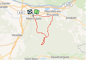
![](/images/other/stat-length.png)
![Excursión Bici de montaña Meyrargues - De Meyrargues au Jas du Ligourès et au Vallon du Puits - Photo](https://media.geolcdn.com/t/1900/400/ext.pjpeg?maxdim=2&url=https%3A%2F%2Fstatic1.geolcdn.com%2Fsiteimages%2Fupload%2Ffiles%2F1524743154velo.jpg)
De Meyrargues au Jas du Ligourès et au Vallon du Puits
Coqorico
Usuario
![Longitud](/images/other/stat-length.png)
![Altitud máxima](https://static1.geolcdn.com/siteimages/upload/files/1508320355ic_sort_altitude_max_24dp.png)
![Desnivel positivo](https://static1.geolcdn.com/siteimages/upload/files/1508320355ic_sort_den_pos_24dp.png)
![Km-Effort](/images/other/stat-length.png)
![Altitud mínima](https://static1.geolcdn.com/siteimages/upload/files/1508320355ic_sort_altitude_min_24dp.png)
![Desnivel negativo](https://static1.geolcdn.com/siteimages/upload/files/1508320355ic_sort_den_neg_24dp.png)
![Boucle](https://static1.geolcdn.com/siteimages/upload/files/16400158638029165_repeat_loop_refresh_sync_direction_icon.png)
![Bici de montaña](https://static1.geolcdn.com/sitytour/trail-icons/202.png)
1h51
Dificultad : Fácil
![Escanee este código QR para abrir la excursión en la aplicación SityTrail](https://capi.geolives.com/qq0zvz2zws4bq2lad0pu/sitytour/trails/2715356/qr.png?size=200)
Aplicación GPS de excursión GRATIS
A propósito
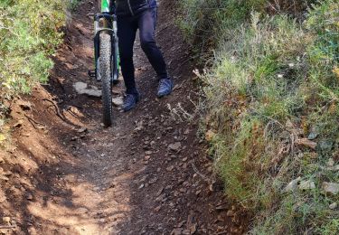
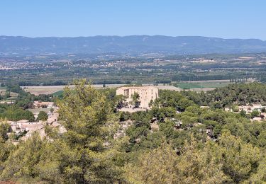
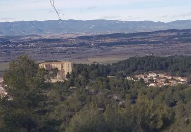
Ruta Bici de montaña de 25 km a descubrir en Provenza-Alpes-Costa Azul, Bocas del Ródano, Meyrargues. Esta ruta ha sido propuesta por Coqorico.
Descripción
Départ de Meyrargues le long du canal EDF pour emprunter la montée des Lavandes et le chemin du Bès jusqu'au jas de Ligourès. De là descente par le single du Puits et remontée par la piste main droite pour enfin redescendre sur Meyrargues par le pas de l'Étroit.
Il est possible selon l'envie de varier la descente (le Brûlé et le single du Petit, le Lauvas, etc.)
Pas de difficulté particulière en-dehors du single du Puits qui reste facile (VTT semi-rigide).
Localización
Comentarios
Excursiones cerca
![Senderismo Senderismo](https://static1.geolcdn.com/sitytour/trail-icons/101.png)
Senderismo
![](/images/other/stat-length.png)
![](https://static1.geolcdn.com/siteimages/upload/files/16400158638029165_repeat_loop_refresh_sync_direction_icon.png)
![Excursión Senderismo Meyrargues - Meyrargue Camp chinois Vallon du petit - Photo](https://media.geolcdn.com/t/375/260/bdb76f07-312d-4412-8213-94a98c001771.jpg&format=jpg&maxdim=2)
![Senderismo Senderismo](https://static1.geolcdn.com/sitytour/trail-icons/101.png)
Senderismo
![](/images/other/stat-length.png)
![](https://static1.geolcdn.com/siteimages/upload/files/16400158638029165_repeat_loop_refresh_sync_direction_icon.png)
![Excursión Senderismo Peyrolles-en-Provence - Ancien canal du Verdon 1.5.22 - Photo](https://media.geolcdn.com/t/375/260/62ebffa6-ce90-44d1-8a5a-2da46d971824.jpg&format=jpg&maxdim=2)
![Senderismo Senderismo](https://static1.geolcdn.com/sitytour/trail-icons/101.png)
Senderismo
![](/images/other/stat-length.png)
![](https://static1.geolcdn.com/siteimages/upload/files/16400158638029165_repeat_loop_refresh_sync_direction_icon.png)
![Excursión Senderismo Peyrolles-en-Provence - loubatas-Camp Chinois-retour par les vallons - Photo](https://media.geolcdn.com/t/375/260/eef47ac4-c641-43d2-bb84-26631de69203.jpg&format=jpg&maxdim=2)
![Senderismo Senderismo](https://static1.geolcdn.com/sitytour/trail-icons/101.png)
Senderismo
![](/images/other/stat-length.png)
![](https://static1.geolcdn.com/siteimages/upload/files/16400158638029165_repeat_loop_refresh_sync_direction_icon.png)
![Excursión Senderismo Peyrolles-en-Provence - PF-Peyrolles-en-Provence - Notre Dame d'Astors - Photo](https://media.geolcdn.com/t/375/260/da3fa0b3-39ff-44df-8458-8b11162830b1.jpg&format=jpg&maxdim=2)
![Senderismo Senderismo](https://static1.geolcdn.com/sitytour/trail-icons/101.png)
Senderismo
![](/images/other/stat-length.png)
![](https://static1.geolcdn.com/siteimages/upload/files/16400158638029165_repeat_loop_refresh_sync_direction_icon.png)
![Excursión Senderismo Peyrolles-en-Provence - PF-Peyrolles-Sentier du Loubatas - Photo](https://media.geolcdn.com/t/375/260/ext.jpg?maxdim=2&url=https%3A%2F%2Fservices.sitytrail.com%2FGeolivesWS%2FDownloadMedia.ashx%3FTrailID%3D537957%26Media%3D20160314160329.jpg)
![Senderismo Senderismo](https://static1.geolcdn.com/sitytour/trail-icons/101.png)
Senderismo
![](/images/other/stat-length.png)
![](https://static1.geolcdn.com/siteimages/upload/files/16400158638029165_repeat_loop_refresh_sync_direction_icon.png)
![Excursión Bici de montaña Venelles - venelles isa jeff - Photo](https://media.geolcdn.com/t/375/260/d4832cbe-4880-482f-ae46-7170caae83c8.jpg&format=jpg&maxdim=2)
![Bici de montaña Bici de montaña](https://static1.geolcdn.com/sitytour/trail-icons/202.png)
Bici de montaña
![](/images/other/stat-length.png)
![](https://static1.geolcdn.com/siteimages/upload/files/16400158638029165_repeat_loop_refresh_sync_direction_icon.png)
![Excursión Senderismo Meyrargues - alentours de Meyrargues tracé bleu - Photo](https://media.geolcdn.com/t/375/260/8d4af597-6f33-40b4-95e0-5e2b2f11b4b9.jpg&format=jpg&maxdim=2)
![Senderismo Senderismo](https://static1.geolcdn.com/sitytour/trail-icons/101.png)
Senderismo
![](/images/other/stat-length.png)
![](https://static1.geolcdn.com/siteimages/upload/files/16400158638029165_repeat_loop_refresh_sync_direction_icon.png)
![Excursión Senderismo Meyrargues - Meyrargues - Par vallon de Lazare - Photo](https://media.geolcdn.com/t/375/260/569d1ad8-ad21-4242-9681-6080f9908d1b.jpg&format=jpg&maxdim=2)
![Senderismo Senderismo](https://static1.geolcdn.com/sitytour/trail-icons/101.png)
Senderismo
![](/images/other/stat-length.png)
![](https://static1.geolcdn.com/siteimages/upload/files/16400158638029165_repeat_loop_refresh_sync_direction_icon.png)