![](/images/other/stat-length.png)
![Excursión Senderismo Jette - Jardins du fleuriste - Photo](https://media.geolcdn.com/t/1900/400/5f3c7e00-c882-46b1-bb86-1835701f7888.jpg&format=pjpeg&maxdim=2)
Jardins du fleuriste
naturon
Usuario
![Longitud](/images/other/stat-length.png)
Longitud
9,2 km
![Altitud máxima](https://static1.geolcdn.com/siteimages/upload/files/1508320355ic_sort_altitude_max_24dp.png)
Altitud máxima
71 m
![Desnivel positivo](https://static1.geolcdn.com/siteimages/upload/files/1508320355ic_sort_den_pos_24dp.png)
Desnivel positivo
122 m
![Km-Effort](/images/other/stat-length.png)
Km-Effort
10,9 km
![Altitud mínima](https://static1.geolcdn.com/siteimages/upload/files/1508320355ic_sort_altitude_min_24dp.png)
Altitud mínima
24 m
![Desnivel negativo](https://static1.geolcdn.com/siteimages/upload/files/1508320355ic_sort_den_neg_24dp.png)
Desnivel negativo
123 m
![Boucle](https://static1.geolcdn.com/siteimages/upload/files/16400158638029165_repeat_loop_refresh_sync_direction_icon.png)
Boucle
Sí
Fecha de creación :
2021-03-19 09:29:32.419
Última modificación :
2021-03-20 08:42:28.413
![Senderismo](https://static1.geolcdn.com/sitytour/trail-icons/101.png)
3h00
Dificultad : Muy fácil
![Escanee este código QR para abrir la excursión en la aplicación SityTrail](https://capi.geolives.com/qq0zvz2zws4bq2lad0pu/sitytour/trails/2712594/qr.png?size=200)
Aplicación GPS de excursión GRATIS
A propósito
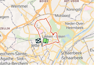
Ruta Senderismo de 9,2 km a descubrir en Région de Bruxelles-Capitale - Brussels Hoofdstedelijk Gewest, Desconocido, Jette. Esta ruta ha sido propuesta por naturon.
Descripción
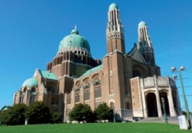
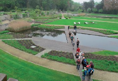
Balade de ± 9 kms, passant par Notre-Dame de Laeken, les jardins du fleuriste et devant les palais d'exposition, retour vers Jette.
Localización
País:
Belgium
Región :
Région de Bruxelles-Capitale - Brussels Hoofdstedelijk Gewest
Departamento/provincia :
Desconocido
Municipio :
Jette
Localidad:
Jette
Salida:(Dec)
Salida:(UTM)
593846 ; 5636768 (31U) N.
Comentarios
Excursiones cerca
![Excursión Senderismo Saint-Josse-ten-Noode - Sint-Joost-ten-Node - RB-BXL-12 - Photo](https://media.geolcdn.com/t/375/260/ext.jpg?maxdim=2&url=https%3A%2F%2Fservices.sitytrail.com%2FGeolivesWS%2FDownloadMedia.ashx%3FTrailID%3D247909%26Media%3D1e73b1c1-685b-4b18-8885-19b8987940e4.jpg)
![Senderismo Senderismo](https://static1.geolcdn.com/sitytour/trail-icons/101.png)
RB-BXL-12
Senderismo
Fácil
(5)
Saint-Josse-ten-Noode - Sint-Joost-ten-Node,
Région de Bruxelles-Capitale - Brussels Hoofdstedelijk Gewest,
Desconocido,
Belgium
![](/images/other/stat-length.png)
12,8 km | 15,1 km-effort
3h 26min
![](https://static1.geolcdn.com/siteimages/upload/files/16400158638029165_repeat_loop_refresh_sync_direction_icon.png)
Sí
![Excursión Senderismo Bruselas - Nuit du scoutisme - Bruxelles - Photo](https://media.geolcdn.com/t/375/260/f0d47147-f47c-4200-a98a-0900b420d45c.jpg&format=jpg&maxdim=2)
![Senderismo Senderismo](https://static1.geolcdn.com/sitytour/trail-icons/101.png)
Nuit du scoutisme - Bruxelles
Senderismo
Medio
(13)
Bruselas,
Région de Bruxelles-Capitale - Brussels Hoofdstedelijk Gewest,
Desconocido,
Belgium
![](/images/other/stat-length.png)
5,8 km | 7,2 km-effort
1h 30min
![](https://static1.geolcdn.com/siteimages/upload/files/16400158638029165_repeat_loop_refresh_sync_direction_icon.png)
No
![Excursión Senderismo Anderlecht - RB-BX-05-Rac02 - Photo](https://media.geolcdn.com/t/375/260/ext.jpg?maxdim=2&url=https%3A%2F%2Fservices.sitytrail.com%2FGeolivesWS%2FDownloadMedia.ashx%3FTrailID%3D247888%26Media%3Defa9a3b4-e0b1-4a00-9376-0ef985b02cd6.jpg)
![Senderismo Senderismo](https://static1.geolcdn.com/sitytour/trail-icons/101.png)
RB-BX-05-Rac02
Senderismo
Fácil
(5)
Anderlecht,
Région de Bruxelles-Capitale - Brussels Hoofdstedelijk Gewest,
Desconocido,
Belgium
![](/images/other/stat-length.png)
14,3 km | 16,6 km-effort
3h 46min
![](https://static1.geolcdn.com/siteimages/upload/files/16400158638029165_repeat_loop_refresh_sync_direction_icon.png)
Sí
![Excursión Senderismo Anderlecht - RB-BXL-05 - Photo](https://media.geolcdn.com/t/375/260/ext.jpg?maxdim=2&url=https%3A%2F%2Fservices.sitytrail.com%2FGeolivesWS%2FDownloadMedia.ashx%3FTrailID%3D247884%26Media%3Defa9a3b4-e0b1-4a00-9376-0ef985b02cd6.jpg)
![Senderismo Senderismo](https://static1.geolcdn.com/sitytour/trail-icons/101.png)
RB-BXL-05
Senderismo
Difícil
(3)
Anderlecht,
Région de Bruxelles-Capitale - Brussels Hoofdstedelijk Gewest,
Desconocido,
Belgium
![](/images/other/stat-length.png)
23 km | 27 km-effort
6h 8min
![](https://static1.geolcdn.com/siteimages/upload/files/16400158638029165_repeat_loop_refresh_sync_direction_icon.png)
Sí
![Excursión Senderismo San Juan de Molenbeek - RB-BXL-04 - Photo](https://media.geolcdn.com/t/375/260/ext.jpg?maxdim=2&url=https%3A%2F%2Fservices.sitytrail.com%2FGeolivesWS%2FDownloadMedia.ashx%3FTrailID%3D247883%26Media%3De6a7a7ca-c658-4857-8e1b-9ec70ca63e16.jpg)
![Senderismo Senderismo](https://static1.geolcdn.com/sitytour/trail-icons/101.png)
RB-BXL-04
Senderismo
Fácil
(1)
San Juan de Molenbeek,
Région de Bruxelles-Capitale - Brussels Hoofdstedelijk Gewest,
Desconocido,
Belgium
![](/images/other/stat-length.png)
15 km | 17,4 km-effort
3h 56min
![](https://static1.geolcdn.com/siteimages/upload/files/16400158638029165_repeat_loop_refresh_sync_direction_icon.png)
No
![Excursión Senderismo Jette - RB-BXL-03 - Photo](https://media.geolcdn.com/t/375/260/ext.jpg?maxdim=2&url=https%3A%2F%2Fservices.sitytrail.com%2FGeolivesWS%2FDownloadMedia.ashx%3FTrailID%3D247875%26Media%3D148492a9-407c-49a4-a3b7-d7d8d6aa5fa9.jpg)
![Senderismo Senderismo](https://static1.geolcdn.com/sitytour/trail-icons/101.png)
RB-BXL-03
Senderismo
Muy difícil
(2)
Jette,
Région de Bruxelles-Capitale - Brussels Hoofdstedelijk Gewest,
Desconocido,
Belgium
![](/images/other/stat-length.png)
25 km | 29 km-effort
6h 38min
![](https://static1.geolcdn.com/siteimages/upload/files/16400158638029165_repeat_loop_refresh_sync_direction_icon.png)
Sí
![Excursión Senderismo Bruselas - RB-BXL-02 - Photo](https://media.geolcdn.com/t/375/260/ext.jpg?maxdim=2&url=https%3A%2F%2Fservices.sitytrail.com%2FGeolivesWS%2FDownloadMedia.ashx%3FTrailID%3D247873%26Media%3Ddfaf2d4a-e0b3-4c36-97b5-3b14c6762b25.jpg)
![Senderismo Senderismo](https://static1.geolcdn.com/sitytour/trail-icons/101.png)
RB-BXL-02
Senderismo
Medio
(1)
Bruselas,
Région de Bruxelles-Capitale - Brussels Hoofdstedelijk Gewest,
Desconocido,
Belgium
![](/images/other/stat-length.png)
21 km | 24 km-effort
5h 32min
![](https://static1.geolcdn.com/siteimages/upload/files/16400158638029165_repeat_loop_refresh_sync_direction_icon.png)
Sí
![Excursión Senderismo Bruselas - RB-Br-01 Raccourci - Photo](https://media.geolcdn.com/t/375/260/ext.jpg?maxdim=2&url=https%3A%2F%2Fservices.sitytrail.com%2FGeolivesWS%2FDownloadMedia.ashx%3FTrailID%3D247871%26Media%3Dc4587231-2ae7-41fa-9d29-8fa1efb02129.jpg)
![Senderismo Senderismo](https://static1.geolcdn.com/sitytour/trail-icons/101.png)
RB-Br-01 Raccourci
Senderismo
Fácil
(3)
Bruselas,
Région de Bruxelles-Capitale - Brussels Hoofdstedelijk Gewest,
Desconocido,
Belgium
![](/images/other/stat-length.png)
16 km | 19 km-effort
4h 19min
![](https://static1.geolcdn.com/siteimages/upload/files/16400158638029165_repeat_loop_refresh_sync_direction_icon.png)
Sí
![Senderismo Senderismo](https://static1.geolcdn.com/sitytour/trail-icons/101.png)
#230714 - Dilbeek, Kattenberg, Rés. Nat. Wolfsputten
Senderismo
Medio
(1)
Dilbeek,
Flandes,
Brabante Flamenco,
Belgium
![](/images/other/stat-length.png)
5,1 km | 6,2 km-effort
1h 24min
![](https://static1.geolcdn.com/siteimages/upload/files/16400158638029165_repeat_loop_refresh_sync_direction_icon.png)
Sí