![](/images/other/stat-length.png)
![Excursión Senderismo Pontorson - GR34 étape 6 - Photo](https://media.geolcdn.com/t/1900/400/ext.pjpeg?maxdim=2&url=https%3A%2F%2Fservices.sitytrail.com%2FGeolivesWS%2FDownloadMedia.ashx%3FTrailID%3D271016%26Media%3Dfix__20140412093116.jpg)
GR34 étape 6
lagardienne
Usuario
![Longitud](/images/other/stat-length.png)
Longitud
23 km
![Altitud máxima](https://static1.geolcdn.com/siteimages/upload/files/1508320355ic_sort_altitude_max_24dp.png)
Altitud máxima
82 m
![Desnivel positivo](https://static1.geolcdn.com/siteimages/upload/files/1508320355ic_sort_den_pos_24dp.png)
Desnivel positivo
166 m
![Km-Effort](/images/other/stat-length.png)
Km-Effort
25 km
![Altitud mínima](https://static1.geolcdn.com/siteimages/upload/files/1508320355ic_sort_altitude_min_24dp.png)
Altitud mínima
2 m
![Desnivel negativo](https://static1.geolcdn.com/siteimages/upload/files/1508320355ic_sort_den_neg_24dp.png)
Desnivel negativo
163 m
![Boucle](https://static1.geolcdn.com/siteimages/upload/files/16400158638029165_repeat_loop_refresh_sync_direction_icon.png)
Boucle
No
Fecha de creación :
2014-12-10 00:00:00.0
Última modificación :
2014-12-10 00:00:00.0
![Senderismo](https://static1.geolcdn.com/sitytour/trail-icons/101.png)
5h30
Dificultad : Fácil
![Escanee este código QR para abrir la excursión en la aplicación SityTrail](https://capi.geolives.com/qq0zvz2zws4bq2lad0pu/sitytour/trails/271016/qr.png?size=200)
Aplicación GPS de excursión GRATIS
A propósito
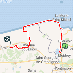
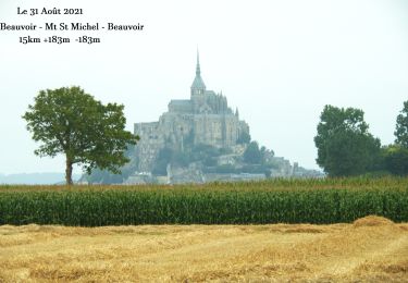
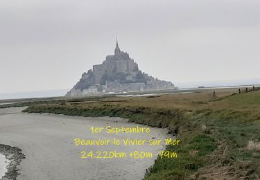
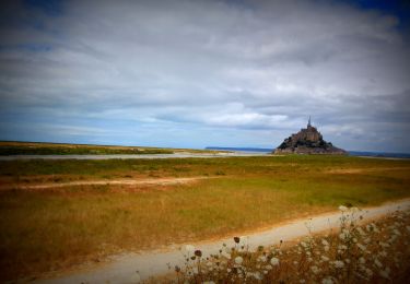
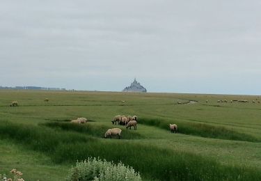
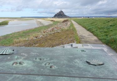
Ruta Senderismo de 23 km a descubrir en Normandía, Mancha, Pontorson. Esta ruta ha sido propuesta por lagardienne.
Descripción
Bientôt sur le jardindelolo.fr le récit de mon périple sur le GR 34, étape par étape avec commentaires et photos.
Localización
País:
France
Región :
Normandía
Departamento/provincia :
Mancha
Municipio :
Pontorson
Localidad:
Pontorson
Salida:(Dec)
Salida:(UTM)
609605 ; 5381870 (30U) N.
Comentarios
Excursiones cerca
![Excursión Senderismo Monte Saint-Michel - Mont St Michel J2 - Photo](https://media.geolcdn.com/t/375/260/b4e16eca-62f6-4a45-b3f4-364badeabd8c.jpg&format=jpg&maxdim=2)
![Senderismo Senderismo](https://static1.geolcdn.com/sitytour/trail-icons/101.png)
Mont St Michel J2
Senderismo
Muy fácil
Monte Saint-Michel,
Normandía,
Mancha,
France
![](/images/other/stat-length.png)
17,4 km | 21 km-effort
4h 22min
![](https://static1.geolcdn.com/siteimages/upload/files/16400158638029165_repeat_loop_refresh_sync_direction_icon.png)
Sí
![Excursión Senderismo Monte Saint-Michel - Mont St Michel J1 - Photo](https://media.geolcdn.com/t/375/260/2b75de4d-6596-478a-9a3f-dcd60f498a33.jpg&format=jpg&maxdim=2)
![Senderismo Senderismo](https://static1.geolcdn.com/sitytour/trail-icons/101.png)
Mont St Michel J1
Senderismo
Difícil
Monte Saint-Michel,
Normandía,
Mancha,
France
![](/images/other/stat-length.png)
12,1 km | 14 km-effort
2h 46min
![](https://static1.geolcdn.com/siteimages/upload/files/16400158638029165_repeat_loop_refresh_sync_direction_icon.png)
Sí
![Excursión A pie Saint-Georges-de-Gréhaigne - Circuit du Petit Bois & de la Grève - Photo](https://media.geolcdn.com/t/375/260/5902253f-7208-4ff1-b384-45fcc25c7a03.jpeg&format=jpg&maxdim=2)
![A pie A pie](https://static1.geolcdn.com/sitytour/trail-icons/100.png)
Circuit du Petit Bois & de la Grève
A pie
Fácil
Saint-Georges-de-Gréhaigne,
Bretaña,
Ille-et-Vilaine,
France
![](/images/other/stat-length.png)
9,1 km | 10,4 km-effort
2h 21min
![](https://static1.geolcdn.com/siteimages/upload/files/16400158638029165_repeat_loop_refresh_sync_direction_icon.png)
Sí
![Excursión A pie Saint-Georges-de-Gréhaigne - Découverte des polders - Photo](https://media.geolcdn.com/t/375/260/1947c4ab-7a2f-4caa-9962-ed302558c2aa.jpeg&format=jpg&maxdim=2)
![A pie A pie](https://static1.geolcdn.com/sitytour/trail-icons/100.png)
Découverte des polders
A pie
Fácil
Saint-Georges-de-Gréhaigne,
Bretaña,
Ille-et-Vilaine,
France
![](/images/other/stat-length.png)
14,6 km | 15,3 km-effort
3h 27min
![](https://static1.geolcdn.com/siteimages/upload/files/16400158638029165_repeat_loop_refresh_sync_direction_icon.png)
Sí
![Excursión Senderismo Beauvoir - N°0 GR34 Beauvoir -- Mont St Michel -- Beauvoir - Photo](https://media.geolcdn.com/t/375/260/ad92d366-53f3-47e6-821c-d2813336be7e.jpg&format=jpg&maxdim=2)
![Senderismo Senderismo](https://static1.geolcdn.com/sitytour/trail-icons/101.png)
N°0 GR34 Beauvoir -- Mont St Michel -- Beauvoir
Senderismo
Difícil
Beauvoir,
Normandía,
Mancha,
France
![](/images/other/stat-length.png)
14,9 km | 17,3 km-effort
3h 55min
![](https://static1.geolcdn.com/siteimages/upload/files/16400158638029165_repeat_loop_refresh_sync_direction_icon.png)
Sí
![Excursión Senderismo Beauvoir - N°1 GR34 Beauvoir -- Le Vivier-sur-Mer - Photo](https://media.geolcdn.com/t/375/260/d6dcce93-6874-4297-ba3a-4d6b0fb11eaf.jpg&format=jpg&maxdim=2)
![Senderismo Senderismo](https://static1.geolcdn.com/sitytour/trail-icons/101.png)
N°1 GR34 Beauvoir -- Le Vivier-sur-Mer
Senderismo
Fácil
Beauvoir,
Normandía,
Mancha,
France
![](/images/other/stat-length.png)
25 km | 27 km-effort
6h 9min
![](https://static1.geolcdn.com/siteimages/upload/files/16400158638029165_repeat_loop_refresh_sync_direction_icon.png)
No
![Bici de montaña Bici de montaña](https://static1.geolcdn.com/sitytour/trail-icons/202.png)
SityTrail - 2506836 - beauvoir_20200724_092923
Bici de montaña
Medio
Beauvoir,
Normandía,
Mancha,
France
![](/images/other/stat-length.png)
29 km | 32 km-effort
Desconocido
![](https://static1.geolcdn.com/siteimages/upload/files/16400158638029165_repeat_loop_refresh_sync_direction_icon.png)
Sí
![Excursión Senderismo Huisnes-sur-Mer - Mont-St-Michel - 14km 64m 4h30 - 2017 06 26 - Photo](https://media.geolcdn.com/t/375/260/9d39b175-437c-4c0f-9152-c4bc208b1660.jpg&format=jpg&maxdim=2)
![Senderismo Senderismo](https://static1.geolcdn.com/sitytour/trail-icons/101.png)
Mont-St-Michel - 14km 64m 4h30 - 2017 06 26
Senderismo
Fácil
Huisnes-sur-Mer,
Normandía,
Mancha,
France
![](/images/other/stat-length.png)
14 km | 15 km-effort
4h 30min
![](https://static1.geolcdn.com/siteimages/upload/files/16400158638029165_repeat_loop_refresh_sync_direction_icon.png)
Sí
![Excursión Senderismo Monte Saint-Michel - GR_34_AA_01_Mt-St-Michel_St-Marcan_20230318 - Photo](https://media.geolcdn.com/t/375/260/a17250a1-0bf7-444e-8b49-3029941c7cbf.jpg&format=jpg&maxdim=2)
![Senderismo Senderismo](https://static1.geolcdn.com/sitytour/trail-icons/101.png)
GR_34_AA_01_Mt-St-Michel_St-Marcan_20230318
Senderismo
Muy fácil
Monte Saint-Michel,
Normandía,
Mancha,
France
![](/images/other/stat-length.png)
16,7 km | 18,7 km-effort
4h 1min
![](https://static1.geolcdn.com/siteimages/upload/files/16400158638029165_repeat_loop_refresh_sync_direction_icon.png)
No