![](/images/other/stat-length.png)
![Excursión Senderismo Saint-Jean-du-Bruel - Aveyron - St-Jean-du-Bruel La haute-vallée de la Dourbies 16km 560m - Photo](https://media.geolcdn.com/t/1900/400/ext.pjpeg?maxdim=2&url=https%3A%2F%2Fstatic1.geolcdn.com%2Fsiteimages%2Fupload%2Ffiles%2F1553511878bg_sport_marche.png)
Aveyron - St-Jean-du-Bruel La haute-vallée de la Dourbies 16km 560m
RandoVal
Usuario
![Longitud](/images/other/stat-length.png)
Longitud
15,6 km
![Altitud máxima](https://static1.geolcdn.com/siteimages/upload/files/1508320355ic_sort_altitude_max_24dp.png)
Altitud máxima
810 m
![Desnivel positivo](https://static1.geolcdn.com/siteimages/upload/files/1508320355ic_sort_den_pos_24dp.png)
Desnivel positivo
612 m
![Km-Effort](/images/other/stat-length.png)
Km-Effort
24 km
![Altitud mínima](https://static1.geolcdn.com/siteimages/upload/files/1508320355ic_sort_altitude_min_24dp.png)
Altitud mínima
510 m
![Desnivel negativo](https://static1.geolcdn.com/siteimages/upload/files/1508320355ic_sort_den_neg_24dp.png)
Desnivel negativo
616 m
![Boucle](https://static1.geolcdn.com/siteimages/upload/files/16400158638029165_repeat_loop_refresh_sync_direction_icon.png)
Boucle
Sí
Fecha de creación :
2021-03-11 20:16:56.526
Última modificación :
2021-04-03 05:07:55.339
![Senderismo](https://static1.geolcdn.com/sitytour/trail-icons/101.png)
--
Dificultad : Desconocido
![Escanee este código QR para abrir la excursión en la aplicación SityTrail](https://capi.geolives.com/qq0zvz2zws4bq2lad0pu/sitytour/trails/2704072/qr.png?size=200)
Aplicación GPS de excursión GRATIS
A propósito
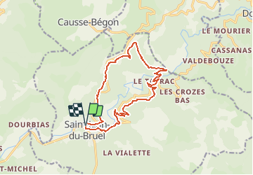
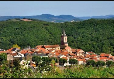
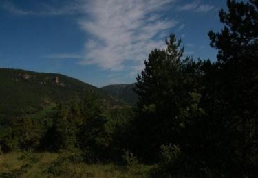
Ruta Senderismo de 15,6 km a descubrir en Occitania, Aveyron, Saint-Jean-du-Bruel. Esta ruta ha sido propuesta por RandoVal.
Descripción
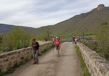
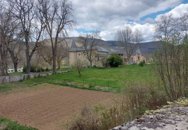
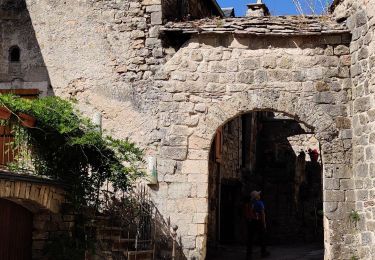
Boucle dans la vallée de la Dourbies, stationnement et départ place de la Borie à St-Jean-du-Bruel, sens horaire, balisage jaune.
Localización
País:
France
Región :
Occitania
Departamento/provincia :
Aveyron
Municipio :
Saint-Jean-du-Bruel
Localidad:
Unknown
Salida:(Dec)
Salida:(UTM)
528819 ; 4874677 (31T) N.
Comentarios
Excursiones cerca
![Excursión Senderismo Nant - Nant Cantobre Nant - Photo](https://media.geolcdn.com/t/375/260/99d31aff-73ea-4c1a-b4d4-b5e03dd8ad46.jpg&format=jpg&maxdim=2)
![Senderismo Senderismo](https://static1.geolcdn.com/sitytour/trail-icons/101.png)
Nant Cantobre Nant
Senderismo
Medio
Nant,
Occitania,
Aveyron,
France
![](/images/other/stat-length.png)
15,3 km | 23 km-effort
7h 1min
![](https://static1.geolcdn.com/siteimages/upload/files/16400158638029165_repeat_loop_refresh_sync_direction_icon.png)
Sí
![Excursión Senderismo Saint-Jean-du-Bruel - Le roc nantais - Photo](https://media.geolcdn.com/t/375/260/94ceee24-fb8f-473f-9011-8f0673a97ba3.jpg&format=jpg&maxdim=2)
![Senderismo Senderismo](https://static1.geolcdn.com/sitytour/trail-icons/101.png)
Le roc nantais
Senderismo
Medio
Saint-Jean-du-Bruel,
Occitania,
Aveyron,
France
![](/images/other/stat-length.png)
22 km | 32 km-effort
7h 7min
![](https://static1.geolcdn.com/siteimages/upload/files/16400158638029165_repeat_loop_refresh_sync_direction_icon.png)
Sí
![Excursión Senderismo Nant - Cantobre 31-08-21 - Photo](https://media.geolcdn.com/t/375/260/65778937-ad87-4a3f-bce1-9b6d4315009b.jpg&format=jpg&maxdim=2)
![Senderismo Senderismo](https://static1.geolcdn.com/sitytour/trail-icons/101.png)
Cantobre 31-08-21
Senderismo
Medio
Nant,
Occitania,
Aveyron,
France
![](/images/other/stat-length.png)
15,5 km | 23 km-effort
4h 14min
![](https://static1.geolcdn.com/siteimages/upload/files/16400158638029165_repeat_loop_refresh_sync_direction_icon.png)
Sí
![Excursión Senderismo Nant - de nant à cantobre - Photo](https://media.geolcdn.com/t/375/260/4b4772e2-a1ba-407a-9750-fec20a2fced0.jpg&format=jpg&maxdim=2)
![Senderismo Senderismo](https://static1.geolcdn.com/sitytour/trail-icons/101.png)
de nant à cantobre
Senderismo
Medio
Nant,
Occitania,
Aveyron,
France
![](/images/other/stat-length.png)
21 km | 32 km-effort
7h 31min
![](https://static1.geolcdn.com/siteimages/upload/files/16400158638029165_repeat_loop_refresh_sync_direction_icon.png)
Sí
![Excursión Carrera Nant - Trail hopitalier 2016 - Photo](https://media.geolcdn.com/t/375/260/ext.jpg?maxdim=2&url=https%3A%2F%2Fstatic1.geolcdn.com%2Fsiteimages%2Fupload%2Ffiles%2F1524743154running.jpg)
![Carrera Carrera](https://static1.geolcdn.com/sitytour/trail-icons/103.png)
Trail hopitalier 2016
Carrera
Muy fácil
(2)
Nant,
Occitania,
Aveyron,
France
![](/images/other/stat-length.png)
29 km | 45 km-effort
Desconocido
![](https://static1.geolcdn.com/siteimages/upload/files/16400158638029165_repeat_loop_refresh_sync_direction_icon.png)
Sí
![Excursión Senderismo Saint-Jean-du-Bruel - la vallée de la Dourbie - Photo](https://media.geolcdn.com/t/375/260/ext.jpg?maxdim=2&url=https%3A%2F%2Fstatic1.geolcdn.com%2Fsiteimages%2Fupload%2Ffiles%2F1553511878bg_sport_marche.png)
![Senderismo Senderismo](https://static1.geolcdn.com/sitytour/trail-icons/101.png)
la vallée de la Dourbie
Senderismo
Difícil
(3)
Saint-Jean-du-Bruel,
Occitania,
Aveyron,
France
![](/images/other/stat-length.png)
19,1 km | 28 km-effort
5h 48min
![](https://static1.geolcdn.com/siteimages/upload/files/16400158638029165_repeat_loop_refresh_sync_direction_icon.png)
Sí
![Excursión Senderismo Nant - roc nantais - Photo](https://media.geolcdn.com/t/375/260/ext.jpg?maxdim=2&url=https%3A%2F%2Fstatic1.geolcdn.com%2Fsiteimages%2Fupload%2Ffiles%2F1553511878bg_sport_marche.png)
![Senderismo Senderismo](https://static1.geolcdn.com/sitytour/trail-icons/101.png)
roc nantais
Senderismo
Difícil
(3)
Nant,
Occitania,
Aveyron,
France
![](/images/other/stat-length.png)
12,4 km | 19,1 km-effort
4h 2min
![](https://static1.geolcdn.com/siteimages/upload/files/16400158638029165_repeat_loop_refresh_sync_direction_icon.png)
Sí
![Excursión Bicicleta Nant - Circuit des 10 plus beaux villages de France de l'Aveyron - Nant - Réquista - Photo](https://media.geolcdn.com/t/375/260/ext.jpg?maxdim=2&url=https%3A%2F%2Fservices.sitytrail.com%2FGeolivesWS%2FDownloadMedia.ashx%3FTrailID%3D172362%26Media%3D13702_5.jpg)
![Bicicleta Bicicleta](https://static1.geolcdn.com/sitytour/trail-icons/200.png)
Circuit des 10 plus beaux villages de France de l'Aveyron - Nant - Réquista
Bicicleta
Difícil
Nant,
Occitania,
Aveyron,
France
![](/images/other/stat-length.png)
103 km | 126 km-effort
6h 0min
![](https://static1.geolcdn.com/siteimages/upload/files/16400158638029165_repeat_loop_refresh_sync_direction_icon.png)
No
![Excursión Senderismo Nant - Le Martoulet - Nant - Photo](https://media.geolcdn.com/t/375/260/ext.jpg?maxdim=2&url=https%3A%2F%2Fservices.sitytrail.com%2FGeolivesWS%2FDownloadMedia.ashx%3FTrailID%3D105371%26Media%3D9073_3.jpg)
![Senderismo Senderismo](https://static1.geolcdn.com/sitytour/trail-icons/101.png)
Le Martoulet - Nant
Senderismo
Medio
(1)
Nant,
Occitania,
Aveyron,
France
![](/images/other/stat-length.png)
7,9 km | 12,8 km-effort
3h 0min
![](https://static1.geolcdn.com/siteimages/upload/files/16400158638029165_repeat_loop_refresh_sync_direction_icon.png)
Sí