![](/images/other/stat-length.png)
![Excursión Senderismo Saint-Antonin-sur-Bayon - Ste Victoire - Le Garagaï - Photo](https://media.geolcdn.com/t/1900/400/2ae6dfca-d10e-4ad0-a555-d7a2df31e780.jpg&format=pjpeg&maxdim=2)
Ste Victoire - Le Garagaï
ETMU5496
Usuario
![Longitud](/images/other/stat-length.png)
![Altitud máxima](https://static1.geolcdn.com/siteimages/upload/files/1508320355ic_sort_altitude_max_24dp.png)
![Desnivel positivo](https://static1.geolcdn.com/siteimages/upload/files/1508320355ic_sort_den_pos_24dp.png)
![Km-Effort](/images/other/stat-length.png)
![Altitud mínima](https://static1.geolcdn.com/siteimages/upload/files/1508320355ic_sort_altitude_min_24dp.png)
![Desnivel negativo](https://static1.geolcdn.com/siteimages/upload/files/1508320355ic_sort_den_neg_24dp.png)
![Boucle](https://static1.geolcdn.com/siteimages/upload/files/16400158638029165_repeat_loop_refresh_sync_direction_icon.png)
![Senderismo](https://static1.geolcdn.com/sitytour/trail-icons/101.png)
4h36
Dificultad : Difícil
![Escanee este código QR para abrir la excursión en la aplicación SityTrail](https://capi.geolives.com/qq0zvz2zws4bq2lad0pu/sitytour/trails/2702628/qr.png?size=200)
Aplicación GPS de excursión GRATIS
A propósito
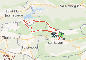
Ruta Senderismo de 15,8 km a descubrir en Provenza-Alpes-Costa Azul, Bocas del Ródano, Saint-Antonin-sur-Bayon. Esta ruta ha sido propuesta por ETMU5496.
Descripción
Départ : maison de la Ste Victoire à St Antonin
La Croix de Provence par le sentier noir du Garagaï.
De la Croix redescente par le sentier bleu de la moucha jusqu'au barrage de Bismont.
Retour par le GR jusqu'au refuge Cezanne. Poursuivre pour se diriger à une bifurcation vers l'oppidum.
Puis redescente au point de départ
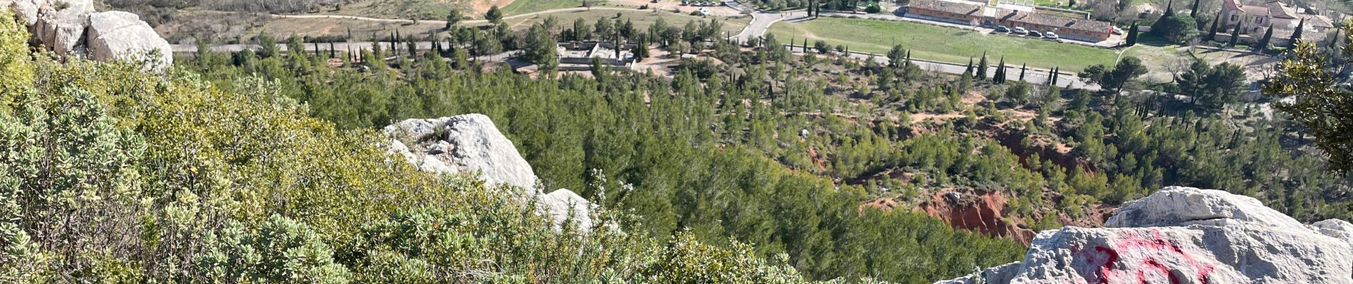
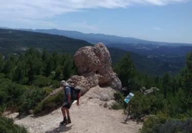
Localización
Comentarios
Excursiones cerca
![Excursión Senderismo Saint-Marc-Jaumegarde - Barrages Zola-Bimont - Photo](https://media.geolcdn.com/t/375/260/4dc70101-718b-4211-92e1-c206f426269b.jpg&format=jpg&maxdim=2)
![Senderismo Senderismo](https://static1.geolcdn.com/sitytour/trail-icons/101.png)
Senderismo
![](/images/other/stat-length.png)
![](https://static1.geolcdn.com/siteimages/upload/files/16400158638029165_repeat_loop_refresh_sync_direction_icon.png)
![Excursión Senderismo Vauvenargues - Le Signal, Montagne Sainte-Victoire - Photo](https://media.geolcdn.com/t/375/260/ext.jpg?maxdim=2&url=https%3A%2F%2Fservices.sitytrail.com%2FGeolivesWS%2FDownloadMedia.ashx%3FTrailID%3D106346%26Media%3D10812_1.jpg)
![Senderismo Senderismo](https://static1.geolcdn.com/sitytour/trail-icons/101.png)
Senderismo
![](/images/other/stat-length.png)
![](https://static1.geolcdn.com/siteimages/upload/files/16400158638029165_repeat_loop_refresh_sync_direction_icon.png)
![Excursión Senderismo Saint-Marc-Jaumegarde - La Croix de Provence depuis le barrage de Bimont - Photo](https://media.geolcdn.com/t/375/260/ext.jpg?maxdim=2&url=https%3A%2F%2Fservices.sitytrail.com%2FGeolivesWS%2FDownloadMedia.ashx%3FTrailID%3D103825%26Media%3D6599_1.jpg)
![Senderismo Senderismo](https://static1.geolcdn.com/sitytour/trail-icons/101.png)
Senderismo
![](/images/other/stat-length.png)
![](https://static1.geolcdn.com/siteimages/upload/files/16400158638029165_repeat_loop_refresh_sync_direction_icon.png)
![Excursión Senderismo Saint-Marc-Jaumegarde - Randonnée des crêtes au départ du barrage de Bimont - Photo](https://media.geolcdn.com/t/375/260/f5fd4b67-08c6-4cdc-bfa9-7a770b929a06.jpg&format=jpg&maxdim=2)
![Senderismo Senderismo](https://static1.geolcdn.com/sitytour/trail-icons/101.png)
Senderismo
![](/images/other/stat-length.png)
![](https://static1.geolcdn.com/siteimages/upload/files/16400158638029165_repeat_loop_refresh_sync_direction_icon.png)
![Excursión Senderismo Saint-Antonin-sur-Bayon - 2023-02-10 Sainte Victoire Bau des Vespres - Photo](https://media.geolcdn.com/t/375/260/36cf2b9f-8e2f-45fe-90b0-1fa100759227.jpg&format=jpg&maxdim=2)
![Senderismo Senderismo](https://static1.geolcdn.com/sitytour/trail-icons/101.png)
Senderismo
![](/images/other/stat-length.png)
![](https://static1.geolcdn.com/siteimages/upload/files/16400158638029165_repeat_loop_refresh_sync_direction_icon.png)
![Excursión A pie Vauvenargues - Sentier des Venturiers - Photo](https://media.geolcdn.com/t/375/260/5341af7b-988a-44b4-8aae-b05094ba094c.jpeg&format=jpg&maxdim=2)
![A pie A pie](https://static1.geolcdn.com/sitytour/trail-icons/100.png)
A pie
![](/images/other/stat-length.png)
![](https://static1.geolcdn.com/siteimages/upload/files/16400158638029165_repeat_loop_refresh_sync_direction_icon.png)
![Excursión A pie Beaurecueil - Sentier Imoucha - Photo](https://media.geolcdn.com/t/375/260/f5af4593-aaa3-483d-ba03-c377e3e38e89.jpeg&format=jpg&maxdim=2)
![A pie A pie](https://static1.geolcdn.com/sitytour/trail-icons/100.png)
A pie
![](/images/other/stat-length.png)
![](https://static1.geolcdn.com/siteimages/upload/files/16400158638029165_repeat_loop_refresh_sync_direction_icon.png)
![Excursión Senderismo Saint-Antonin-sur-Bayon - le Garagai, signal - Photo](https://media.geolcdn.com/t/375/260/b9f06065-1a82-41b0-8991-082c30e8856b.jpg&format=jpg&maxdim=2)
![Senderismo Senderismo](https://static1.geolcdn.com/sitytour/trail-icons/101.png)
Senderismo
![](/images/other/stat-length.png)
![](https://static1.geolcdn.com/siteimages/upload/files/16400158638029165_repeat_loop_refresh_sync_direction_icon.png)
![Excursión Senderismo Saint-Antonin-sur-Bayon - la croix de Provence - Photo](https://media.geolcdn.com/t/375/260/3b7d0402-2017-4bd3-8849-2084e87f3c42.jpg&format=jpg&maxdim=2)
![Senderismo Senderismo](https://static1.geolcdn.com/sitytour/trail-icons/101.png)
Senderismo
![](/images/other/stat-length.png)
![](https://static1.geolcdn.com/siteimages/upload/files/16400158638029165_repeat_loop_refresh_sync_direction_icon.png)