![](/images/other/stat-length.png)
![Excursión Senderismo Bouillon - Abbaye de Clairefontaine/Bouillon. - Photo](https://media.geolcdn.com/t/1900/400/0f2504a3-9538-48f0-ada9-96c712277617.jpg&format=pjpeg&maxdim=2)
Abbaye de Clairefontaine/Bouillon.
gcrappe
Usuario
![Longitud](/images/other/stat-length.png)
Longitud
9,9 km
![Altitud máxima](https://static1.geolcdn.com/siteimages/upload/files/1508320355ic_sort_altitude_max_24dp.png)
Altitud máxima
383 m
![Desnivel positivo](https://static1.geolcdn.com/siteimages/upload/files/1508320355ic_sort_den_pos_24dp.png)
Desnivel positivo
263 m
![Km-Effort](/images/other/stat-length.png)
Km-Effort
13,4 km
![Altitud mínima](https://static1.geolcdn.com/siteimages/upload/files/1508320355ic_sort_altitude_min_24dp.png)
Altitud mínima
213 m
![Desnivel negativo](https://static1.geolcdn.com/siteimages/upload/files/1508320355ic_sort_den_neg_24dp.png)
Desnivel negativo
265 m
![Boucle](https://static1.geolcdn.com/siteimages/upload/files/16400158638029165_repeat_loop_refresh_sync_direction_icon.png)
Boucle
Sí
Fecha de creación :
2021-03-01 14:00:43.983
Última modificación :
2021-03-01 18:24:29.402
![Senderismo](https://static1.geolcdn.com/sitytour/trail-icons/101.png)
2h48
Dificultad : Medio
![Escanee este código QR para abrir la excursión en la aplicación SityTrail](https://capi.geolives.com/qq0zvz2zws4bq2lad0pu/sitytour/trails/2691214/qr.png?size=200)
Aplicación GPS de excursión GRATIS
A propósito
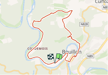
Ruta Senderismo de 9,9 km a descubrir en Valonia, Luxemburgo, Bouillon. Esta ruta ha sido propuesta por gcrappe.
Descripción
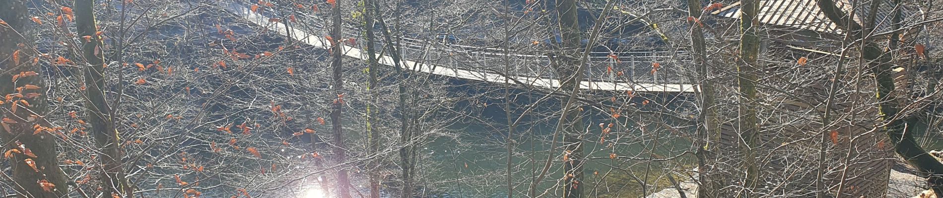
Balade le long de la Semois, Abbaye de Clairefontaine, passerelle du moulin, montée dans les bois, parcelle de petits sapins sur le plateau, point de vue du belvédère, descente dans les bois sur Bouillon, quai de Semois, retour au parking.
Localización
País:
Belgium
Región :
Valonia
Departamento/provincia :
Luxemburgo
Municipio :
Bouillon
Localidad:
Bouillon
Salida:(Dec)
Salida:(UTM)
648102 ; 5517395 (31U) N.
Comentarios
Excursiones cerca
![Excursión Senderismo Bouillon - RB-LUX-13 - Les belvédères bouillonnais - Photo](https://media.geolcdn.com/t/375/260/ext.jpg?maxdim=2&url=https%3A%2F%2Fservices.sitytrail.com%2FGeolivesWS%2FDownloadMedia.ashx%3FTrailID%3D179618%26Media%3Dc93ae6e1-6a5c-490e-ab2b-3f360dd3a9f8.jpg)
![Senderismo Senderismo](https://static1.geolcdn.com/sitytour/trail-icons/101.png)
RB-LUX-13 - Les belvédères bouillonnais
Senderismo
Medio
(8)
Bouillon,
Valonia,
Luxemburgo,
Belgium
![](/images/other/stat-length.png)
20 km | 30 km-effort
5h 55min
![](https://static1.geolcdn.com/siteimages/upload/files/16400158638029165_repeat_loop_refresh_sync_direction_icon.png)
Sí
![Excursión Senderismo Bouillon - Marche ADEPS à Bouillon 8km500 - Photo](https://media.geolcdn.com/t/375/260/1579ffd1-b437-4fe4-a5cc-0a3a87fba898.jpg&format=jpg&maxdim=2)
![Senderismo Senderismo](https://static1.geolcdn.com/sitytour/trail-icons/101.png)
Marche ADEPS à Bouillon 8km500
Senderismo
Difícil
(1)
Bouillon,
Valonia,
Luxemburgo,
Belgium
![](/images/other/stat-length.png)
8,4 km | 12,5 km-effort
2h 28min
![](https://static1.geolcdn.com/siteimages/upload/files/16400158638029165_repeat_loop_refresh_sync_direction_icon.png)
Sí
![Excursión Senderismo Bouillon - RB-LUX-13 - Raccourci - Les belvédères bouillonnais - Photo](https://media.geolcdn.com/t/375/260/ext.jpg?maxdim=2&url=https%3A%2F%2Fservices.sitytrail.com%2FGeolivesWS%2FDownloadMedia.ashx%3FTrailID%3D216805%26Media%3Dc93ae6e1-6a5c-490e-ab2b-3f360dd3a9f8.jpg)
![Senderismo Senderismo](https://static1.geolcdn.com/sitytour/trail-icons/101.png)
RB-LUX-13 - Raccourci - Les belvédères bouillonnais
Senderismo
Medio
(4)
Bouillon,
Valonia,
Luxemburgo,
Belgium
![](/images/other/stat-length.png)
16,7 km | 25 km-effort
4h 54min
![](https://static1.geolcdn.com/siteimages/upload/files/16400158638029165_repeat_loop_refresh_sync_direction_icon.png)
Sí
![Excursión Senderismo Bouillon - De Corbion à la Roche aux Eperviers - Photo](https://media.geolcdn.com/t/375/260/ext.jpg?maxdim=2&url=https%3A%2F%2Fservices.sitytrail.com%2FGeolivesWS%2FDownloadMedia.ashx%3FTrailID%3D146950%26Media%3D6d765926-55f0-4539-a611-ffe05c9bf6d8.JPG)
![Senderismo Senderismo](https://static1.geolcdn.com/sitytour/trail-icons/101.png)
De Corbion à la Roche aux Eperviers
Senderismo
Fácil
(2)
Bouillon,
Valonia,
Luxemburgo,
Belgium
![](/images/other/stat-length.png)
10,6 km | 14,6 km-effort
2h 50min
![](https://static1.geolcdn.com/siteimages/upload/files/16400158638029165_repeat_loop_refresh_sync_direction_icon.png)
Sí
![Excursión Senderismo Bouillon - De Poupehan à Frahan par le sentier des crêtes - Photo](https://media.geolcdn.com/t/375/260/ext.jpg?maxdim=2&url=https%3A%2F%2Fservices.sitytrail.com%2FGeolivesWS%2FDownloadMedia.ashx%3FTrailID%3D138478%26Media%3Db86d13b9-d40b-4a52-ab60-15a552c97303.JPG)
![Senderismo Senderismo](https://static1.geolcdn.com/sitytour/trail-icons/101.png)
De Poupehan à Frahan par le sentier des crêtes
Senderismo
Medio
(3)
Bouillon,
Valonia,
Luxemburgo,
Belgium
![](/images/other/stat-length.png)
8,8 km | 12,5 km-effort
3h 0min
![](https://static1.geolcdn.com/siteimages/upload/files/16400158638029165_repeat_loop_refresh_sync_direction_icon.png)
Sí
![Excursión Senderismo Bouillon - De Corbion à Poupehan par la Roche des Fées et la Chaire à Prêcher - Photo](https://media.geolcdn.com/t/375/260/ext.jpg?maxdim=2&url=https%3A%2F%2Fservices.sitytrail.com%2FGeolivesWS%2FDownloadMedia.ashx%3FTrailID%3D138476%26Media%3D05b27b25-8086-41d3-96c5-76c508b6a7d7.JPG)
![Senderismo Senderismo](https://static1.geolcdn.com/sitytour/trail-icons/101.png)
De Corbion à Poupehan par la Roche des Fées et la Chaire à Prêcher
Senderismo
Medio
(2)
Bouillon,
Valonia,
Luxemburgo,
Belgium
![](/images/other/stat-length.png)
7,3 km | 11,1 km-effort
3h 0min
![](https://static1.geolcdn.com/siteimages/upload/files/16400158638029165_repeat_loop_refresh_sync_direction_icon.png)
Sí
![Excursión Senderismo Bouillon - Corbion - Le Sentier des Points de Vue - Photo](https://media.geolcdn.com/t/375/260/ext.jpg?maxdim=2&url=https%3A%2F%2Fservices.sitytrail.com%2FGeolivesWS%2FDownloadMedia.ashx%3FTrailID%3D138106%26Media%3D530b3448-4c03-4266-ae4e-a2076c332785.JPG)
![Senderismo Senderismo](https://static1.geolcdn.com/sitytour/trail-icons/101.png)
Corbion - Le Sentier des Points de Vue
Senderismo
Medio
(7)
Bouillon,
Valonia,
Luxemburgo,
Belgium
![](/images/other/stat-length.png)
8,6 km | 12,2 km-effort
3h 0min
![](https://static1.geolcdn.com/siteimages/upload/files/16400158638029165_repeat_loop_refresh_sync_direction_icon.png)
Sí
![Excursión Senderismo Bouillon - Promenade vers la Passerelle de l’épine - Photo](https://media.geolcdn.com/t/375/260/a030b44f-54a7-48fb-92fc-a78ebfcb2520.jpg&format=jpg&maxdim=2)
![Senderismo Senderismo](https://static1.geolcdn.com/sitytour/trail-icons/101.png)
Promenade vers la Passerelle de l’épine
Senderismo
Medio
(8)
Bouillon,
Valonia,
Luxemburgo,
Belgium
![](/images/other/stat-length.png)
7,3 km | 11,2 km-effort
2h 33min
![](https://static1.geolcdn.com/siteimages/upload/files/16400158638029165_repeat_loop_refresh_sync_direction_icon.png)
Sí
![Excursión Senderismo Bouillon - Poupehan_Rochehaut_Frahan_Poupzhan - Photo](https://media.geolcdn.com/t/375/260/0b4f111d-644c-4d33-b812-a15a1b8098b1.jpg&format=jpg&maxdim=2)
![Senderismo Senderismo](https://static1.geolcdn.com/sitytour/trail-icons/101.png)
Poupehan_Rochehaut_Frahan_Poupzhan
Senderismo
Medio
(4)
Bouillon,
Valonia,
Luxemburgo,
Belgium
![](/images/other/stat-length.png)
12,8 km | 18,7 km-effort
5h 7min
![](https://static1.geolcdn.com/siteimages/upload/files/16400158638029165_repeat_loop_refresh_sync_direction_icon.png)
Sí