![](/images/other/stat-length.png)
![Excursión A pie Houyet - Gendron-Celles - Photo](https://media.geolcdn.com/t/1900/400/ext.pjpeg?maxdim=2&url=https%3A%2F%2Fstatic1.geolcdn.com%2Fsiteimages%2Fupload%2Ffiles%2F1545311037marcheuse_200dpi.jpg)
Gendron-Celles
r.genette
Usuario
![Longitud](/images/other/stat-length.png)
Longitud
9,1 km
![Altitud máxima](https://static1.geolcdn.com/siteimages/upload/files/1508320355ic_sort_altitude_max_24dp.png)
Altitud máxima
240 m
![Desnivel positivo](https://static1.geolcdn.com/siteimages/upload/files/1508320355ic_sort_den_pos_24dp.png)
Desnivel positivo
228 m
![Km-Effort](/images/other/stat-length.png)
Km-Effort
12,1 km
![Altitud mínima](https://static1.geolcdn.com/siteimages/upload/files/1508320355ic_sort_altitude_min_24dp.png)
Altitud mínima
109 m
![Desnivel negativo](https://static1.geolcdn.com/siteimages/upload/files/1508320355ic_sort_den_neg_24dp.png)
Desnivel negativo
235 m
![Boucle](https://static1.geolcdn.com/siteimages/upload/files/16400158638029165_repeat_loop_refresh_sync_direction_icon.png)
Boucle
Sí
Fecha de creación :
2021-03-01 12:38:44.045
Última modificación :
2021-03-02 09:33:16.692
![A pie](https://static1.geolcdn.com/sitytour/trail-icons/100.png)
3h00
Dificultad : Medio
![Escanee este código QR para abrir la excursión en la aplicación SityTrail](https://capi.geolives.com/qq0zvz2zws4bq2lad0pu/sitytour/trails/2691056/qr.png?size=200)
Aplicación GPS de excursión GRATIS
A propósito
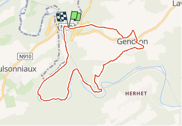
Ruta A pie de 9,1 km a descubrir en Valonia, Namur, Houyet. Esta ruta ha sido propuesta por r.genette.
Descripción
Depuis parking hôtel restaurant Auberge de la Lesse.. vers Gendron.. la vallée de la Lesse.. et retour..
Des dénivelés, des chemins où la prudence s'impose.... mais assez faciles
Localización
País:
Belgium
Región :
Valonia
Departamento/provincia :
Namur
Municipio :
Houyet
Localidad:
Celles
Salida:(Dec)
Salida:(UTM)
640254 ; 5563949 (31U) N.
Comentarios
Excursiones cerca
![Excursión Senderismo Dinant - RB-Na-24-Entre Lesse et Meuse - Photo](https://media.geolcdn.com/t/375/260/ext.jpg?maxdim=2&url=https%3A%2F%2Fmedia.geolcdn.com%2Ff%2F8f83e767-34d7-4d4c-9347-54379d263207.JPG)
![Senderismo Senderismo](https://static1.geolcdn.com/sitytour/trail-icons/101.png)
RB-Na-24-Entre Lesse et Meuse
Senderismo
Muy difícil
(14)
Dinant,
Valonia,
Namur,
Belgium
![](/images/other/stat-length.png)
19,3 km | 26 km-effort
5h 57min
![](https://static1.geolcdn.com/siteimages/upload/files/16400158638029165_repeat_loop_refresh_sync_direction_icon.png)
Sí
![Excursión Senderismo Houyet - Nature - The Payenne trail (Houyet) - Photo](https://media.geolcdn.com/t/375/260/ext.jpg?maxdim=2&url=https%3A%2F%2Fservices.sitytrail.com%2FGeolivesWS%2FDownloadMedia.ashx%3FTrailID%3D247221%26Media%3D4a1116e4-3cc3-4f81-a279-87cb261b0cef.jpg)
![Senderismo Senderismo](https://static1.geolcdn.com/sitytour/trail-icons/101.png)
Nature - The Payenne trail (Houyet)
Senderismo
Difícil
(5)
Houyet,
Valonia,
Namur,
Belgium
![](/images/other/stat-length.png)
14,3 km | 19 km-effort
4h 18min
![](https://static1.geolcdn.com/siteimages/upload/files/16400158638029165_repeat_loop_refresh_sync_direction_icon.png)
Sí
![Excursión Senderismo Houyet - Nature - Royal Park walk - Houyet - Photo](https://media.geolcdn.com/t/375/260/ext.jpg?maxdim=2&url=https%3A%2F%2Fservices.sitytrail.com%2FGeolivesWS%2FDownloadMedia.ashx%3FTrailID%3D193546%26Media%3D0a2a8593-cf69-475f-a9b0-b2a4af4f959b.jpg)
![Senderismo Senderismo](https://static1.geolcdn.com/sitytour/trail-icons/101.png)
Nature - Royal Park walk - Houyet
Senderismo
Difícil
(14)
Houyet,
Valonia,
Namur,
Belgium
![](/images/other/stat-length.png)
5,7 km | 7,8 km-effort
1h 47min
![](https://static1.geolcdn.com/siteimages/upload/files/16400158638029165_repeat_loop_refresh_sync_direction_icon.png)
Sí
![Excursión Senderismo Houyet - Houyet - Pî-sinte po tortos - Walk for everyone - On foot, by bicycle, on horseback, wheelchair accessible - Photo](https://media.geolcdn.com/t/375/260/ext.jpg?maxdim=2&url=https%3A%2F%2Fservices.sitytrail.com%2FGeolivesWS%2FDownloadMedia.ashx%3FTrailID%3D193539%26Media%3D6b85272b-deee-4a79-9526-05b6bf74491c.jpg)
![Senderismo Senderismo](https://static1.geolcdn.com/sitytour/trail-icons/101.png)
Houyet - Pî-sinte po tortos - Walk for everyone - On foot, by bicycle, on ho...
Senderismo
(6)
Houyet,
Valonia,
Namur,
Belgium
![](/images/other/stat-length.png)
4,3 km | 4,9 km-effort
1h 0min
![](https://static1.geolcdn.com/siteimages/upload/files/16400158638029165_repeat_loop_refresh_sync_direction_icon.png)
Sí
![Excursión Senderismo Houyet - La Lesse, Natura 2000 - Des sites qui valent le détour, Na07 - Photo](https://media.geolcdn.com/t/375/260/ext.jpg?maxdim=2&url=https%3A%2F%2Fservices.sitytrail.com%2FGeolivesWS%2FDownloadMedia.ashx%3FTrailID%3D188163%26Media%3Df0b29f0e-e19a-4fa8-a869-5ab27b1769d7.JPG)
![Senderismo Senderismo](https://static1.geolcdn.com/sitytour/trail-icons/101.png)
La Lesse, Natura 2000 - Des sites qui valent le détour, Na07
Senderismo
Difícil
(9)
Houyet,
Valonia,
Namur,
Belgium
![](/images/other/stat-length.png)
8,8 km | 11,5 km-effort
2h 33min
![](https://static1.geolcdn.com/siteimages/upload/files/16400158638029165_repeat_loop_refresh_sync_direction_icon.png)
Sí
![Excursión Senderismo Houyet - RB-Na-05 Hauts lieux de la basse Lesse - Photo](https://media.geolcdn.com/t/375/260/ext.jpg?maxdim=2&url=https%3A%2F%2Fservices.sitytrail.com%2FGeolivesWS%2FDownloadMedia.ashx%3FTrailID%3D179631%26Media%3D95d7547e-2b07-4681-8a2a-4a37901ae9c7.jpg)
![Senderismo Senderismo](https://static1.geolcdn.com/sitytour/trail-icons/101.png)
RB-Na-05 Hauts lieux de la basse Lesse
Senderismo
Medio
(9)
Houyet,
Valonia,
Namur,
Belgium
![](/images/other/stat-length.png)
24 km | 31 km-effort
6h 33min
![](https://static1.geolcdn.com/siteimages/upload/files/16400158638029165_repeat_loop_refresh_sync_direction_icon.png)
Sí
![Excursión Senderismo Houyet - Nature - Houyet, a royal municipality - Photo](https://media.geolcdn.com/t/375/260/ext.jpg?maxdim=2&url=https%3A%2F%2Fservices.sitytrail.com%2FGeolivesWS%2FDownloadMedia.ashx%3FTrailID%3D166040%26Media%3D0a2a8593-cf69-475f-a9b0-b2a4af4f959b.jpg)
![Senderismo Senderismo](https://static1.geolcdn.com/sitytour/trail-icons/101.png)
Nature - Houyet, a royal municipality
Senderismo
Difícil
(14)
Houyet,
Valonia,
Namur,
Belgium
![](/images/other/stat-length.png)
8,3 km | 11,5 km-effort
2h 33min
![](https://static1.geolcdn.com/siteimages/upload/files/16400158638029165_repeat_loop_refresh_sync_direction_icon.png)
Sí
![Excursión Senderismo Houyet - RB-Na-05 Raccourci 1 - Hauts lieux de la basse Lesse - Photo](https://media.geolcdn.com/t/375/260/ext.jpg?maxdim=2&url=https%3A%2F%2Fservices.sitytrail.com%2FGeolivesWS%2FDownloadMedia.ashx%3FTrailID%3D213753%26Media%3D8bab1d47-4651-4050-8b88-78bf90d52eb5.jpg)
![Senderismo Senderismo](https://static1.geolcdn.com/sitytour/trail-icons/101.png)
RB-Na-05 Raccourci 1 - Hauts lieux de la basse Lesse
Senderismo
Fácil
(5)
Houyet,
Valonia,
Namur,
Belgium
![](/images/other/stat-length.png)
21 km | 26 km-effort
5h 37min
![](https://static1.geolcdn.com/siteimages/upload/files/16400158638029165_repeat_loop_refresh_sync_direction_icon.png)
Sí
![Excursión Senderismo Houyet - Nature & heritage in Celles, one of the Most Beautiful Villages of Wallonia - Photo](https://media.geolcdn.com/t/375/260/ext.jpg?maxdim=2&url=https%3A%2F%2Fmedia.geolcdn.com%2Ff%2Fac9d387c-3f8d-401d-bffe-044b71ce3eff.jpg)
![Senderismo Senderismo](https://static1.geolcdn.com/sitytour/trail-icons/101.png)
Nature & heritage in Celles, one of the Most Beautiful Villages of Wallonia
Senderismo
Medio
(6)
Houyet,
Valonia,
Namur,
Belgium
![](/images/other/stat-length.png)
9,6 km | 12,7 km-effort
2h 52min
![](https://static1.geolcdn.com/siteimages/upload/files/16400158638029165_repeat_loop_refresh_sync_direction_icon.png)
Sí