![](/images/other/stat-length.png)
![Excursión A pie Ampuis - Vérenay - 10,6 km - 363 m de dénivelé - 3h30 - Photo](https://media.geolcdn.com/t/1900/400/ext.pjpeg?maxdim=2&url=https%3A%2F%2Fstatic1.geolcdn.com%2Fsiteimages%2Fupload%2Ffiles%2F1545311037marcheuse_200dpi.jpg)
Vérenay - 10,6 km - 363 m de dénivelé - 3h30
Clubléorando
Usuario
![Longitud](/images/other/stat-length.png)
Longitud
10,6 km
![Altitud máxima](https://static1.geolcdn.com/siteimages/upload/files/1508320355ic_sort_altitude_max_24dp.png)
Altitud máxima
380 m
![Desnivel positivo](https://static1.geolcdn.com/siteimages/upload/files/1508320355ic_sort_den_pos_24dp.png)
Desnivel positivo
363 m
![Km-Effort](/images/other/stat-length.png)
Km-Effort
15,4 km
![Altitud mínima](https://static1.geolcdn.com/siteimages/upload/files/1508320355ic_sort_altitude_min_24dp.png)
Altitud mínima
152 m
![Desnivel negativo](https://static1.geolcdn.com/siteimages/upload/files/1508320355ic_sort_den_neg_24dp.png)
Desnivel negativo
363 m
![Boucle](https://static1.geolcdn.com/siteimages/upload/files/16400158638029165_repeat_loop_refresh_sync_direction_icon.png)
Boucle
Sí
Fecha de creación :
2021-02-24 15:41:34.001
Última modificación :
2023-12-30 10:30:09.399
![A pie](https://static1.geolcdn.com/sitytour/trail-icons/100.png)
3h30
Dificultad : Medio
![Escanee este código QR para abrir la excursión en la aplicación SityTrail](https://capi.geolives.com/qq0zvz2zws4bq2lad0pu/sitytour/trails/2683589/qr.png?size=200)
Aplicación GPS de excursión GRATIS
A propósito
Ruta A pie de 10,6 km a descubrir en Auvergne-Rhône-Alpes, Ródano, Ampuis. Esta ruta ha sido propuesta por Clubléorando.
Descripción
Balade en boucle au départ du parking, rue de Montlys, au village de Vérenay. Montée et descente par des sentiers un peu raides à travers les vignes
Localización
País:
France
Región :
Auvergne-Rhône-Alpes
Departamento/provincia :
Ródano
Municipio :
Ampuis
Localidad:
Unknown
Salida:(Dec)
Salida:(UTM)
643345 ; 5040576 (31T) N.
Comentarios
Excursiones cerca
![Excursión Senderismo Loire-sur-Rhône - 42 le grisard (vienne) - Photo](https://media.geolcdn.com/t/375/260/c8c552c2-c833-47f9-98c4-fadea207952f.jpg&format=jpg&maxdim=2)
![Senderismo Senderismo](https://static1.geolcdn.com/sitytour/trail-icons/101.png)
42 le grisard (vienne)
Senderismo
Muy fácil
Loire-sur-Rhône,
Auvergne-Rhône-Alpes,
Ródano,
France
![](/images/other/stat-length.png)
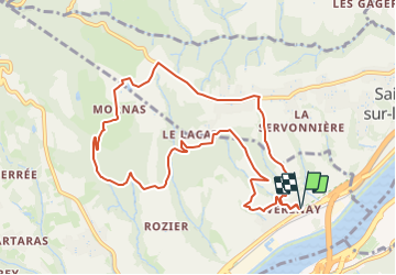
5,6 km | 8,2 km-effort
2h 8min
![](https://static1.geolcdn.com/siteimages/upload/files/16400158638029165_repeat_loop_refresh_sync_direction_icon.png)
Sí
![Excursión Senderismo Saint-Romain-en-Gal - le grisard - Photo](https://media.geolcdn.com/t/375/260/ext.jpg?maxdim=2&url=https%3A%2F%2Fstatic1.geolcdn.com%2Fsiteimages%2Fupload%2Ffiles%2F1553511878bg_sport_marche.png)
![Senderismo Senderismo](https://static1.geolcdn.com/sitytour/trail-icons/101.png)
le grisard
Senderismo
Medio
(1)
Saint-Romain-en-Gal,
Auvergne-Rhône-Alpes,
Ródano,
France
![](/images/other/stat-length.png)
5,3 km | 7,9 km-effort
1h 48min
![](https://static1.geolcdn.com/siteimages/upload/files/16400158638029165_repeat_loop_refresh_sync_direction_icon.png)
Sí
![Excursión Senderismo Reventin-Vaugris - 38-reventin-10km-325m - Photo](https://media.geolcdn.com/t/375/260/4f43ff32-027d-445e-b925-188f68c95bae.jpg&format=jpg&maxdim=2)
![Senderismo Senderismo](https://static1.geolcdn.com/sitytour/trail-icons/101.png)
38-reventin-10km-325m
Senderismo
Fácil
Reventin-Vaugris,
Auvergne-Rhône-Alpes,
Isère,
France
![](/images/other/stat-length.png)
10 km | 14,3 km-effort
3h 5min
![](https://static1.geolcdn.com/siteimages/upload/files/16400158638029165_repeat_loop_refresh_sync_direction_icon.png)
Sí
![Excursión Senderismo Vienne - naïade nocturne digestive à Vienne - Isère - Photo](https://media.geolcdn.com/t/375/260/3e0ddf70-00b3-4de3-8743-20a20b07d4cf.jpg&format=jpg&maxdim=2)
![Senderismo Senderismo](https://static1.geolcdn.com/sitytour/trail-icons/101.png)
naïade nocturne digestive à Vienne - Isère
Senderismo
Muy fácil
Vienne,
Auvergne-Rhône-Alpes,
Isère,
France
![](/images/other/stat-length.png)
3 km | 3,6 km-effort
1h 38min
![](https://static1.geolcdn.com/siteimages/upload/files/16400158638029165_repeat_loop_refresh_sync_direction_icon.png)
Sí
![Excursión Senderismo Loire-sur-Rhône - 69-loire-sur-rhone2-pet-de-loup-18km-560m - Photo](https://media.geolcdn.com/t/375/260/ee6f14b8-8ed9-4a30-84a4-6a7d5babc72f.jpg&format=jpg&maxdim=2)
![Senderismo Senderismo](https://static1.geolcdn.com/sitytour/trail-icons/101.png)
69-loire-sur-rhone2-pet-de-loup-18km-560m
Senderismo
Medio
(1)
Loire-sur-Rhône,
Auvergne-Rhône-Alpes,
Ródano,
France
![](/images/other/stat-length.png)
17,7 km | 25 km-effort
3h 3min
![](https://static1.geolcdn.com/siteimages/upload/files/16400158638029165_repeat_loop_refresh_sync_direction_icon.png)
Sí
![Excursión Senderismo Vienne - 38-Vienne-visite-4.5km-mai21 - Photo](https://media.geolcdn.com/t/375/260/15a6f21e-b5a5-4e05-9520-6ac715530426.jpg&format=jpg&maxdim=2)
![Senderismo Senderismo](https://static1.geolcdn.com/sitytour/trail-icons/101.png)
38-Vienne-visite-4.5km-mai21
Senderismo
Fácil
Vienne,
Auvergne-Rhône-Alpes,
Isère,
France
![](/images/other/stat-length.png)
4,6 km | 5,2 km-effort
1h 47min
![](https://static1.geolcdn.com/siteimages/upload/files/16400158638029165_repeat_loop_refresh_sync_direction_icon.png)
Sí
![Excursión Senderismo Reventin-Vaugris - REVENTIN 18 JC - Photo](https://media.geolcdn.com/t/375/260/ext.jpg?maxdim=2&url=https%3A%2F%2Fstatic1.geolcdn.com%2Fsiteimages%2Fupload%2Ffiles%2F1553511878bg_sport_marche.png)
![Senderismo Senderismo](https://static1.geolcdn.com/sitytour/trail-icons/101.png)
REVENTIN 18 JC
Senderismo
Muy fácil
(1)
Reventin-Vaugris,
Auvergne-Rhône-Alpes,
Isère,
France
![](/images/other/stat-length.png)
7,3 km | 10,5 km-effort
2h 12min
![](https://static1.geolcdn.com/siteimages/upload/files/16400158638029165_repeat_loop_refresh_sync_direction_icon.png)
Sí
![Excursión Senderismo Reventin-Vaugris - REVENTIN VAUGRIS 2 JC - Photo](https://media.geolcdn.com/t/375/260/ext.jpg?maxdim=2&url=https%3A%2F%2Fstatic1.geolcdn.com%2Fsiteimages%2Fupload%2Ffiles%2F1553511878bg_sport_marche.png)
![Senderismo Senderismo](https://static1.geolcdn.com/sitytour/trail-icons/101.png)
REVENTIN VAUGRIS 2 JC
Senderismo
Muy fácil
(1)
Reventin-Vaugris,
Auvergne-Rhône-Alpes,
Isère,
France
![](/images/other/stat-length.png)
12,9 km | 17,8 km-effort
3h 45min
![](https://static1.geolcdn.com/siteimages/upload/files/16400158638029165_repeat_loop_refresh_sync_direction_icon.png)
Sí
![Excursión Senderismo Ampuis - AMPUIS JC - Photo](https://media.geolcdn.com/t/375/260/ext.jpg?maxdim=2&url=https%3A%2F%2Fstatic1.geolcdn.com%2Fsiteimages%2Fupload%2Ffiles%2F1553511878bg_sport_marche.png)
![Senderismo Senderismo](https://static1.geolcdn.com/sitytour/trail-icons/101.png)
AMPUIS JC
Senderismo
Muy fácil
(1)
Ampuis,
Auvergne-Rhône-Alpes,
Ródano,
France
![](/images/other/stat-length.png)
9,7 km | 12,1 km-effort
3h 10min
![](https://static1.geolcdn.com/siteimages/upload/files/16400158638029165_repeat_loop_refresh_sync_direction_icon.png)
Sí