![](/images/other/stat-length.png)
![Excursión Senderismo La Motte - z les demoiselles 23-02-21 - Photo](https://media.geolcdn.com/t/1900/400/ext.pjpeg?maxdim=2&url=https%3A%2F%2Fmedia.geolcdn.com%2Ff%2F00a70929-e169-4fdf-9a12-27895a9a58f8.jpg)
z les demoiselles 23-02-21
cb8310
Usuario
![Longitud](/images/other/stat-length.png)
Longitud
9,3 km
![Altitud máxima](https://static1.geolcdn.com/siteimages/upload/files/1508320355ic_sort_altitude_max_24dp.png)
Altitud máxima
105 m
![Desnivel positivo](https://static1.geolcdn.com/siteimages/upload/files/1508320355ic_sort_den_pos_24dp.png)
Desnivel positivo
90 m
![Km-Effort](/images/other/stat-length.png)
Km-Effort
10,6 km
![Altitud mínima](https://static1.geolcdn.com/siteimages/upload/files/1508320355ic_sort_altitude_min_24dp.png)
Altitud mínima
35 m
![Desnivel negativo](https://static1.geolcdn.com/siteimages/upload/files/1508320355ic_sort_den_neg_24dp.png)
Desnivel negativo
122 m
![Boucle](https://static1.geolcdn.com/siteimages/upload/files/16400158638029165_repeat_loop_refresh_sync_direction_icon.png)
Boucle
No
Fecha de creación :
2021-02-23 12:29:17.744
Última modificación :
2021-02-24 06:14:15.675
![Senderismo](https://static1.geolcdn.com/sitytour/trail-icons/101.png)
2h39
Dificultad : Medio
![Escanee este código QR para abrir la excursión en la aplicación SityTrail](https://capi.geolives.com/qq0zvz2zws4bq2lad0pu/sitytour/trails/2682216/qr.png?size=200)
Aplicación GPS de excursión GRATIS
A propósito
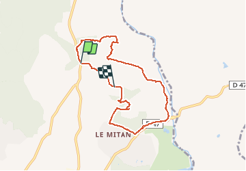
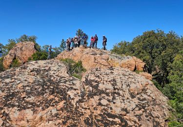
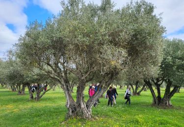
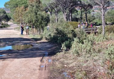
Ruta Senderismo de 9,3 km a descubrir en Provenza-Alpes-Costa Azul, Var, La Motte. Esta ruta ha sido propuesta por cb8310.
Descripción
agréable rando à travers bois, larges pistes et sentiers caillouteux avec jusque ce qu'il faut en petites montées
Localización
País:
France
Región :
Provenza-Alpes-Costa Azul
Departamento/provincia :
Var
Municipio :
La Motte
Localidad:
Unknown
Salida:(Dec)
Salida:(UTM)
303323 ; 4820706 (32T) N.
Comentarios
Excursiones cerca
![Excursión Senderismo Le Muy - les grottes Baume Renaude - Photo](https://media.geolcdn.com/t/375/260/ext.jpg?maxdim=2&url=https%3A%2F%2Fmedia.geolcdn.com%2Ff%2F83f6db30-c43d-4bf1-a9a3-011d52f73567.jpg)
![Senderismo Senderismo](https://static1.geolcdn.com/sitytour/trail-icons/101.png)
les grottes Baume Renaude
Senderismo
Difícil
(1)
Le Muy,
Provenza-Alpes-Costa Azul,
Var,
France
![](/images/other/stat-length.png)
13,3 km | 18,3 km-effort
5h 13min
![](https://static1.geolcdn.com/siteimages/upload/files/16400158638029165_repeat_loop_refresh_sync_direction_icon.png)
No
![Excursión Senderismo Callas - gorge de Penafore - Photo](https://media.geolcdn.com/t/375/260/ext.jpg?maxdim=2&url=https%3A%2F%2Fmedia.geolcdn.com%2Ff%2F19f2f069-7b40-4577-819a-e6663f6d8c61.jpg)
![Senderismo Senderismo](https://static1.geolcdn.com/sitytour/trail-icons/101.png)
gorge de Penafore
Senderismo
Muy fácil
(1)
Callas,
Provenza-Alpes-Costa Azul,
Var,
France
![](/images/other/stat-length.png)
1,1 km | 1,3 km-effort
1h 33min
![](https://static1.geolcdn.com/siteimages/upload/files/16400158638029165_repeat_loop_refresh_sync_direction_icon.png)
Sí
![Excursión Senderismo Le Muy - 2024-04-17_09h53m25_visorando-2024-04-19-les-roches-de-la-fille-isnard-gilles - Photo](https://media.geolcdn.com/t/375/260/ext.jpg?maxdim=2&url=https%3A%2F%2Fmedia.geolcdn.com%2Ff%2F5a621cd3-9532-4383-9ace-ccf70fe1b0c2.jpg)
![Senderismo Senderismo](https://static1.geolcdn.com/sitytour/trail-icons/101.png)
2024-04-17_09h53m25_visorando-2024-04-19-les-roches-de-la-fille-isnard-gilles
Senderismo
Medio
Le Muy,
Provenza-Alpes-Costa Azul,
Var,
France
![](/images/other/stat-length.png)
16,6 km | 23 km-effort
5h 16min
![](https://static1.geolcdn.com/siteimages/upload/files/16400158638029165_repeat_loop_refresh_sync_direction_icon.png)
Sí
![Excursión Senderismo Les Arcs-sur-Argens - LES ARCS - LE MUY - LA MOTTE - SAINTE ROSELINE ET VALBOURGES - Photo](https://media.geolcdn.com/t/375/260/ext.jpg?maxdim=2&url=https%3A%2F%2Fmedia.geolcdn.com%2Ff%2F24a596bd-8063-44a1-bfa4-688d03d8c334.jpg)
![Senderismo Senderismo](https://static1.geolcdn.com/sitytour/trail-icons/101.png)
LES ARCS - LE MUY - LA MOTTE - SAINTE ROSELINE ET VALBOURGES
Senderismo
Fácil
Les Arcs-sur-Argens,
Provenza-Alpes-Costa Azul,
Var,
France
![](/images/other/stat-length.png)
9,1 km | 10,4 km-effort
6h 42min
![](https://static1.geolcdn.com/siteimages/upload/files/16400158638029165_repeat_loop_refresh_sync_direction_icon.png)
Sí
![Excursión Senderismo Le Muy - z le trou de la Jarre 12-03-24 - Photo](https://media.geolcdn.com/t/375/260/ext.jpg?maxdim=2&url=https%3A%2F%2Fmedia.geolcdn.com%2Ff%2F19c5cc5b-c18d-431f-8b04-443a299b25e3.jpg)
![Senderismo Senderismo](https://static1.geolcdn.com/sitytour/trail-icons/101.png)
z le trou de la Jarre 12-03-24
Senderismo
Fácil
Le Muy,
Provenza-Alpes-Costa Azul,
Var,
France
![](/images/other/stat-length.png)
7,3 km | 8,3 km-effort
2h 32min
![](https://static1.geolcdn.com/siteimages/upload/files/16400158638029165_repeat_loop_refresh_sync_direction_icon.png)
Sí
![Excursión Senderismo Le Muy - Le Castel Diaou - Crête Fille d'Isnard depuis le pont de L'Endre - Photo](https://media.geolcdn.com/t/375/260/ext.jpg?maxdim=2&url=https%3A%2F%2Fmedia.geolcdn.com%2Ff%2Fbe9a20a4-3a2b-4a58-ad48-d15f8920c7dd.jpg)
![Senderismo Senderismo](https://static1.geolcdn.com/sitytour/trail-icons/101.png)
Le Castel Diaou - Crête Fille d'Isnard depuis le pont de L'Endre
Senderismo
Muy difícil
Le Muy,
Provenza-Alpes-Costa Azul,
Var,
France
![](/images/other/stat-length.png)
22 km | 31 km-effort
7h 4min
![](https://static1.geolcdn.com/siteimages/upload/files/16400158638029165_repeat_loop_refresh_sync_direction_icon.png)
Sí
![Excursión Senderismo Le Muy - Pas des Vaches - Pic rébéquier - Fontaine du Chasseur - Pic Castel Diaou - Photo](https://media.geolcdn.com/t/375/260/ext.jpg?maxdim=2&url=https%3A%2F%2Fmedia.geolcdn.com%2Ff%2F2b85ee09-1824-4ac8-a041-9e96b6f63a59.jpg)
![Senderismo Senderismo](https://static1.geolcdn.com/sitytour/trail-icons/101.png)
Pas des Vaches - Pic rébéquier - Fontaine du Chasseur - Pic Castel Diaou
Senderismo
Muy difícil
Le Muy,
Provenza-Alpes-Costa Azul,
Var,
France
![](/images/other/stat-length.png)
22 km | 30 km-effort
6h 55min
![](https://static1.geolcdn.com/siteimages/upload/files/16400158638029165_repeat_loop_refresh_sync_direction_icon.png)
Sí
![Excursión Senderismo Callas - La catalane ,Font Blanche, les Cabanons - Photo](https://media.geolcdn.com/t/375/260/ext.jpg?maxdim=2&url=https%3A%2F%2Fmedia.geolcdn.com%2Ff%2Fe9f4ef24-554e-428d-99d0-9e136bb11dfd.jpg)
![Senderismo Senderismo](https://static1.geolcdn.com/sitytour/trail-icons/101.png)
La catalane ,Font Blanche, les Cabanons
Senderismo
Medio
(1)
Callas,
Provenza-Alpes-Costa Azul,
Var,
France
![](/images/other/stat-length.png)
10,3 km | 14,2 km-effort
3h 19min
![](https://static1.geolcdn.com/siteimages/upload/files/16400158638029165_repeat_loop_refresh_sync_direction_icon.png)
Sí
![Excursión Senderismo Le Muy - Forêt du rouet 2 départ parking des plaines - Photo](https://media.geolcdn.com/t/375/260/ext.jpg?maxdim=2&url=https%3A%2F%2Fstatic1.geolcdn.com%2Fsiteimages%2Fupload%2Ffiles%2F1553511878bg_sport_marche.png)
![Senderismo Senderismo](https://static1.geolcdn.com/sitytour/trail-icons/101.png)
Forêt du rouet 2 départ parking des plaines
Senderismo
Medio
(1)
Le Muy,
Provenza-Alpes-Costa Azul,
Var,
France
![](/images/other/stat-length.png)
9,2 km | 10,7 km-effort
2h 26min
![](https://static1.geolcdn.com/siteimages/upload/files/16400158638029165_repeat_loop_refresh_sync_direction_icon.png)
Sí