![](/images/other/stat-length.png)
![Excursión Senderismo Puyloubier - Puyloubier - Oratoire de Malivert - La Pallière - Photo](https://media.geolcdn.com/t/1900/400/ext.pjpeg?maxdim=2&url=https%3A%2F%2Fstatic1.geolcdn.com%2Fsiteimages%2Fupload%2Ffiles%2F1553511878bg_sport_marche.png)
Puyloubier - Oratoire de Malivert - La Pallière
pourrier
Usuario
![Longitud](/images/other/stat-length.png)
![Altitud máxima](https://static1.geolcdn.com/siteimages/upload/files/1508320355ic_sort_altitude_max_24dp.png)
![Desnivel positivo](https://static1.geolcdn.com/siteimages/upload/files/1508320355ic_sort_den_pos_24dp.png)
![Km-Effort](/images/other/stat-length.png)
![Altitud mínima](https://static1.geolcdn.com/siteimages/upload/files/1508320355ic_sort_altitude_min_24dp.png)
![Desnivel negativo](https://static1.geolcdn.com/siteimages/upload/files/1508320355ic_sort_den_neg_24dp.png)
![Boucle](https://static1.geolcdn.com/siteimages/upload/files/16400158638029165_repeat_loop_refresh_sync_direction_icon.png)
![Senderismo](https://static1.geolcdn.com/sitytour/trail-icons/101.png)
5h30
Dificultad : Desconocido
![Escanee este código QR para abrir la excursión en la aplicación SityTrail](https://capi.geolives.com/qq0zvz2zws4bq2lad0pu/sitytour/trails/2679120/qr.png?size=200)
Aplicación GPS de excursión GRATIS
A propósito
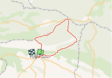
Ruta Senderismo de 14,1 km a descubrir en Provenza-Alpes-Costa Azul, Bocas del Ródano, Puyloubier. Esta ruta ha sido propuesta por pourrier.
Descripción
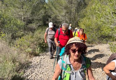
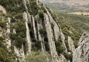
Circuit en partant de Puyloubier. Montée rapide par le GR9 jusqu'à l'altitude 668m puis moins raide jusqu'à l'Oratoire de Malivert.
Poursuite par le Chemin de Malivert à cause du vent violent et des bourrasques qui déséquilibraient jusqu'à la D10.
Poursuite jusqu'à la Pallière et repas sous les 2 chênes majestueux.
Reprise de la descente vers Puyloubier en passant par la Palleirote. et le Clos Sainte Victoire.
Localización
Comentarios
Excursiones cerca
![Excursión Senderismo Puyloubier - 2023-02-03 Sainte Victoire - Le Pic des Mouches - Photo](https://media.geolcdn.com/t/375/260/485b71fb-d444-48f0-93df-e93d563947c5.jpg&format=jpg&maxdim=2)
![Senderismo Senderismo](https://static1.geolcdn.com/sitytour/trail-icons/101.png)
Senderismo
![](/images/other/stat-length.png)
![](https://static1.geolcdn.com/siteimages/upload/files/16400158638029165_repeat_loop_refresh_sync_direction_icon.png)
![Excursión Senderismo Puyloubier - Pic dès mouches puyloubier - Photo](https://media.geolcdn.com/t/375/260/7c244ec8-1dfe-4d0a-987a-96248fbf499f.jpg&format=jpg&maxdim=2)
![Senderismo Senderismo](https://static1.geolcdn.com/sitytour/trail-icons/101.png)
Senderismo
![](/images/other/stat-length.png)
![](https://static1.geolcdn.com/siteimages/upload/files/16400158638029165_repeat_loop_refresh_sync_direction_icon.png)
![Excursión Senderismo Puyloubier - traversée St Ser, le pic des Mouches, Puyloubier - Photo](https://media.geolcdn.com/t/375/260/ext.jpg?maxdim=2&url=https%3A%2F%2Fservices.sitytrail.com%2FGeolivesWS%2FDownloadMedia.ashx%3FTrailID%3D544432%26Media%3Dfix__20160326141759.jpg)
![Senderismo Senderismo](https://static1.geolcdn.com/sitytour/trail-icons/101.png)
Senderismo
![](/images/other/stat-length.png)
![](https://static1.geolcdn.com/siteimages/upload/files/16400158638029165_repeat_loop_refresh_sync_direction_icon.png)
![Excursión Senderismo Puyloubier - Le pic des Mouches par le col de St Ser - Photo](https://media.geolcdn.com/t/375/260/ext.jpg?maxdim=2&url=https%3A%2F%2Fservices.sitytrail.com%2FGeolivesWS%2FDownloadMedia.ashx%3FTrailID%3D413729%26Media%3Dfix__20150429115113.jpg)
![Senderismo Senderismo](https://static1.geolcdn.com/sitytour/trail-icons/101.png)
Senderismo
![](/images/other/stat-length.png)
![](https://static1.geolcdn.com/siteimages/upload/files/16400158638029165_repeat_loop_refresh_sync_direction_icon.png)
![A pie A pie](https://static1.geolcdn.com/sitytour/trail-icons/100.png)
A pie
![](/images/other/stat-length.png)
![](https://static1.geolcdn.com/siteimages/upload/files/16400158638029165_repeat_loop_refresh_sync_direction_icon.png)
![Excursión Senderismo Puyloubier - Puyloubier : St Ser-col des Portes - Photo](https://media.geolcdn.com/t/375/260/0b56fcca-8759-4413-9017-b9e823aea0a6.jpg&format=jpg&maxdim=2)
![Senderismo Senderismo](https://static1.geolcdn.com/sitytour/trail-icons/101.png)
Senderismo
![](/images/other/stat-length.png)
![](https://static1.geolcdn.com/siteimages/upload/files/16400158638029165_repeat_loop_refresh_sync_direction_icon.png)
![Excursión Senderismo Pourrières - Puyloubier - Photo](https://media.geolcdn.com/t/375/260/26e51f64-e9dc-4715-9c05-119db4965cd2.jpg&format=jpg&maxdim=2)
![Senderismo Senderismo](https://static1.geolcdn.com/sitytour/trail-icons/101.png)
Senderismo
![](/images/other/stat-length.png)
![](https://static1.geolcdn.com/siteimages/upload/files/16400158638029165_repeat_loop_refresh_sync_direction_icon.png)
![Excursión Senderismo Puyloubier - Grand couloir - St Ser 19-2-23 - Photo](https://media.geolcdn.com/t/375/260/c2cc593f-229c-4096-851d-f57b94415396.jpg&format=jpg&maxdim=2)
![Senderismo Senderismo](https://static1.geolcdn.com/sitytour/trail-icons/101.png)
Senderismo
![](/images/other/stat-length.png)
![](https://static1.geolcdn.com/siteimages/upload/files/16400158638029165_repeat_loop_refresh_sync_direction_icon.png)
![Excursión Senderismo Puyloubier - Ste Victoire (pic des Mouches et brèche du clapier) - Photo](https://media.geolcdn.com/t/375/260/e67a64f9-9bee-4612-94ef-092747dbfc1f.jpg&format=jpg&maxdim=2)
![Senderismo Senderismo](https://static1.geolcdn.com/sitytour/trail-icons/101.png)
Senderismo
![](/images/other/stat-length.png)
![](https://static1.geolcdn.com/siteimages/upload/files/16400158638029165_repeat_loop_refresh_sync_direction_icon.png)