![](/images/other/stat-length.png)
![Excursión Senderismo Aquisgrán - Kornelimünster - Photo](https://media.geolcdn.com/t/1900/400/ext.pjpeg?maxdim=2&url=https%3A%2F%2Fstatic1.geolcdn.com%2Fsiteimages%2Fupload%2Ffiles%2F1553511878bg_sport_marche.png)
Kornelimünster
flip96
Usuario
![Longitud](/images/other/stat-length.png)
Longitud
17,1 km
![Altitud máxima](https://static1.geolcdn.com/siteimages/upload/files/1508320355ic_sort_altitude_max_24dp.png)
Altitud máxima
317 m
![Desnivel positivo](https://static1.geolcdn.com/siteimages/upload/files/1508320355ic_sort_den_pos_24dp.png)
Desnivel positivo
284 m
![Km-Effort](/images/other/stat-length.png)
Km-Effort
21 km
![Altitud mínima](https://static1.geolcdn.com/siteimages/upload/files/1508320355ic_sort_altitude_min_24dp.png)
Altitud mínima
223 m
![Desnivel negativo](https://static1.geolcdn.com/siteimages/upload/files/1508320355ic_sort_den_neg_24dp.png)
Desnivel negativo
285 m
![Boucle](https://static1.geolcdn.com/siteimages/upload/files/16400158638029165_repeat_loop_refresh_sync_direction_icon.png)
Boucle
Sí
Fecha de creación :
2014-12-10 00:00:00.0
Última modificación :
2014-12-10 00:00:00.0
![Senderismo](https://static1.geolcdn.com/sitytour/trail-icons/101.png)
4h27
Dificultad : Fácil
![Escanee este código QR para abrir la excursión en la aplicación SityTrail](https://capi.geolives.com/qq0zvz2zws4bq2lad0pu/sitytour/trails/267759/qr.png?size=200)
Aplicación GPS de excursión GRATIS
A propósito
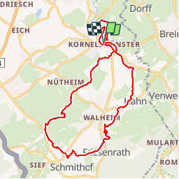
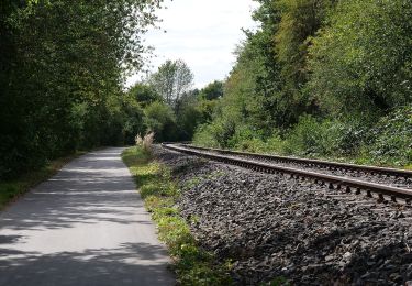
Ruta Senderismo de 17,1 km a descubrir en Renania del Norte-Westfalia, Städteregion Aachen, Aquisgrán. Esta ruta ha sido propuesta por flip96.
Descripción
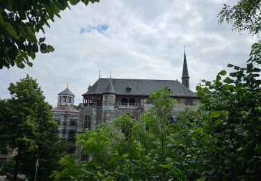
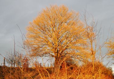
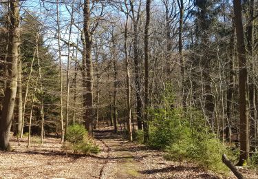
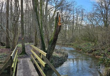
Rondwandeling vanuit Kornelimünster.
Prachtige, eenvoudige wandeling door het groen, langs Iterbach en Inde en het oude stadje Kornelismünster.
Opmerkingen? flip96@home.nl
Localización
País:
Germany
Región :
Renania del Norte-Westfalia
Departamento/provincia :
Städteregion Aachen
Municipio :
Aquisgrán
Localidad:
Kornelimünster/Walheim
Salida:(Dec)
Salida:(UTM)
301139 ; 5623413 (32U) N.
Comentarios
Excursiones cerca
![Excursión Senderismo Aquisgrán - Kornelimünster - Photo](https://media.geolcdn.com/t/375/260/5caf8e34-5825-43c1-849c-6d076a59c5fa.jpg&format=jpg&maxdim=2)
![Senderismo Senderismo](https://static1.geolcdn.com/sitytour/trail-icons/101.png)
Kornelimünster
Senderismo
Medio
(1)
Aquisgrán,
Renania del Norte-Westfalia,
Städteregion Aachen,
Germany
![](/images/other/stat-length.png)
15,5 km | 19,8 km-effort
4h 30min
![](https://static1.geolcdn.com/siteimages/upload/files/16400158638029165_repeat_loop_refresh_sync_direction_icon.png)
Sí
![Excursión Senderismo Raeren - 2022-01-18_14h11m36_lichtenbusch - Photo](https://media.geolcdn.com/t/375/260/83311396-e126-40d9-b822-9da5f0d28323.jpg&format=jpg&maxdim=2)
![Senderismo Senderismo](https://static1.geolcdn.com/sitytour/trail-icons/101.png)
2022-01-18_14h11m36_lichtenbusch
Senderismo
Fácil
(2)
Raeren,
Valonia,
Lieja,
Belgium
![](/images/other/stat-length.png)
14,8 km | 17 km-effort
3h 52min
![](https://static1.geolcdn.com/siteimages/upload/files/16400158638029165_repeat_loop_refresh_sync_direction_icon.png)
Sí
![Excursión A pie Aquisgrán - Rundweg um Eilendorf - Photo](https://media.geolcdn.com/t/375/260/87580b8e-9a60-47cb-a755-acb46765e988.jpeg&format=jpg&maxdim=2)
![A pie A pie](https://static1.geolcdn.com/sitytour/trail-icons/100.png)
Rundweg um Eilendorf
A pie
Fácil
Aquisgrán,
Renania del Norte-Westfalia,
Städteregion Aachen,
Germany
![](/images/other/stat-length.png)
12,6 km | 14,4 km-effort
3h 16min
![](https://static1.geolcdn.com/siteimages/upload/files/16400158638029165_repeat_loop_refresh_sync_direction_icon.png)
Sí
![Excursión A pie Roetgen - Rott Rundweg A3 - Photo](https://media.geolcdn.com/t/375/260/68d54c01-37fc-4225-b77f-3c3692b6e11c.jpeg&format=jpg&maxdim=2)
![A pie A pie](https://static1.geolcdn.com/sitytour/trail-icons/100.png)
Rott Rundweg A3
A pie
Fácil
Roetgen,
Renania del Norte-Westfalia,
Städteregion Aachen,
Germany
![](/images/other/stat-length.png)
4,4 km | 5,8 km-effort
1h 18min
![](https://static1.geolcdn.com/siteimages/upload/files/16400158638029165_repeat_loop_refresh_sync_direction_icon.png)
Sí
![Excursión A pie Aquisgrán - Kalkofenweg - Photo](https://media.geolcdn.com/t/375/260/0acf23cd-5e55-42e1-90ae-3e15385deef5.jpeg&format=jpg&maxdim=2)
![A pie A pie](https://static1.geolcdn.com/sitytour/trail-icons/100.png)
Kalkofenweg
A pie
Fácil
Aquisgrán,
Renania del Norte-Westfalia,
Städteregion Aachen,
Germany
![](/images/other/stat-length.png)
6,9 km | 8,1 km-effort
1h 50min
![](https://static1.geolcdn.com/siteimages/upload/files/16400158638029165_repeat_loop_refresh_sync_direction_icon.png)
Sí
![Excursión A pie Aquisgrán - IndeRoute - Photo](https://media.geolcdn.com/t/375/260/5b45f3d2-bacb-401d-82e5-6a813ae291fc.jpeg&format=jpg&maxdim=2)
![A pie A pie](https://static1.geolcdn.com/sitytour/trail-icons/100.png)
IndeRoute
A pie
Fácil
Aquisgrán,
Renania del Norte-Westfalia,
Städteregion Aachen,
Germany
![](/images/other/stat-length.png)
6,5 km | 8,2 km-effort
1h 52min
![](https://static1.geolcdn.com/siteimages/upload/files/16400158638029165_repeat_loop_refresh_sync_direction_icon.png)
No
![Excursión Senderismo Raeren - 2021-03-04_18h10m39_1023 - Photo](https://media.geolcdn.com/t/375/260/e5c92a16-1a79-4bf9-bcd2-21508d76292d.jpg&format=jpg&maxdim=2)
![Senderismo Senderismo](https://static1.geolcdn.com/sitytour/trail-icons/101.png)
2021-03-04_18h10m39_1023
Senderismo
Fácil
Raeren,
Valonia,
Lieja,
Belgium
![](/images/other/stat-length.png)
17,5 km | 21 km-effort
4h 39min
![](https://static1.geolcdn.com/siteimages/upload/files/16400158638029165_repeat_loop_refresh_sync_direction_icon.png)
No
![Excursión Senderismo Raeren - A la découverte de Lichtenbusch 🥾 - Photo](https://media.geolcdn.com/t/375/260/d85f3b38-8057-41c0-b7d8-4d0370e979ce.jpg&format=jpg&maxdim=2)
![Senderismo Senderismo](https://static1.geolcdn.com/sitytour/trail-icons/101.png)
A la découverte de Lichtenbusch 🥾
Senderismo
Muy fácil
Raeren,
Valonia,
Lieja,
Belgium
![](/images/other/stat-length.png)
15 km | 17,2 km-effort
3h 3min
![](https://static1.geolcdn.com/siteimages/upload/files/16400158638029165_repeat_loop_refresh_sync_direction_icon.png)
Sí
![Excursión A pie Roetgen - Mulartshütte A2 - Photo](https://media.geolcdn.com/t/375/260/88899e7d-f5cf-4aa4-8dfd-83c652889fdc.jpeg&format=jpg&maxdim=2)
![A pie A pie](https://static1.geolcdn.com/sitytour/trail-icons/100.png)
Mulartshütte A2
A pie
Fácil
Roetgen,
Renania del Norte-Westfalia,
Städteregion Aachen,
Germany
![](/images/other/stat-length.png)
5,6 km | 6,7 km-effort
1h 31min
![](https://static1.geolcdn.com/siteimages/upload/files/16400158638029165_repeat_loop_refresh_sync_direction_icon.png)
Sí