![](/images/other/stat-length.png)
![Excursión Paseo ecuestre Ban-de-Laveline - SityTrail - Ban de Laveline - Fraize - Photo](https://media.geolcdn.com/t/1900/400/694a636a-671e-4d6c-a608-c93f86a13122.jpg&format=pjpeg&maxdim=2)
SityTrail - Ban de Laveline - Fraize
Tourisme Equestre Alsace
Promouvoir le Tourisme Equestre en Alsace GUIDE+
![Longitud](/images/other/stat-length.png)
Longitud
19,7 km
![Altitud máxima](https://static1.geolcdn.com/siteimages/upload/files/1508320355ic_sort_altitude_max_24dp.png)
Altitud máxima
1065 m
![Desnivel positivo](https://static1.geolcdn.com/siteimages/upload/files/1508320355ic_sort_den_pos_24dp.png)
Desnivel positivo
741 m
![Km-Effort](/images/other/stat-length.png)
Km-Effort
29 km
![Altitud mínima](https://static1.geolcdn.com/siteimages/upload/files/1508320355ic_sort_altitude_min_24dp.png)
Altitud mínima
422 m
![Desnivel negativo](https://static1.geolcdn.com/siteimages/upload/files/1508320355ic_sort_den_neg_24dp.png)
Desnivel negativo
644 m
![Boucle](https://static1.geolcdn.com/siteimages/upload/files/16400158638029165_repeat_loop_refresh_sync_direction_icon.png)
Boucle
No
Fecha de creación :
2021-02-18 18:35:56.253
Última modificación :
2021-10-04 18:11:41.424
![Paseo ecuestre](https://static1.geolcdn.com/sitytour/trail-icons/301.png)
3h51
Dificultad : Medio
![Escanee este código QR para abrir la excursión en la aplicación SityTrail](https://capi.geolives.com/qq0zvz2zws4bq2lad0pu/sitytour/trails/2675461/qr.png?size=200)
Aplicación GPS de excursión GRATIS
A propósito
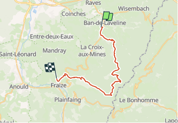
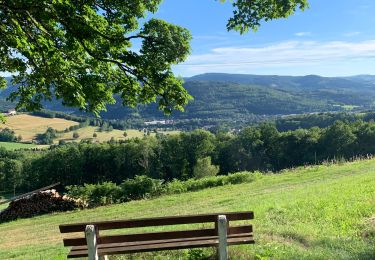
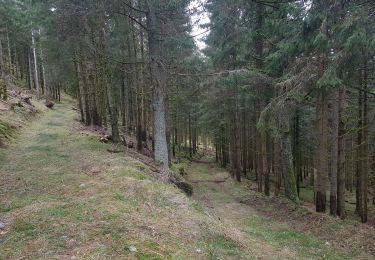
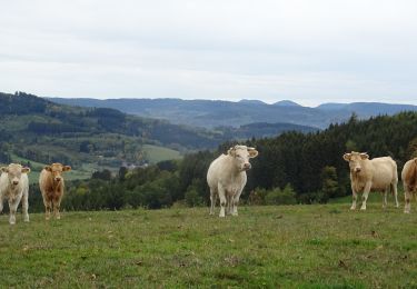
Ruta Paseo ecuestre de 19,7 km a descubrir en Gran Este, Vosgos, Ban-de-Laveline. Esta ruta ha sido propuesta por Tourisme Equestre Alsace.
Descripción
Circuit Entre l’Alsace et les Vosges : Etape entre Ban de Laveline et Fraize
Localización
País:
France
Región :
Gran Este
Departamento/provincia :
Vosgos
Municipio :
Ban-de-Laveline
Localidad:
Unknown
Salida:(Dec)
Salida:(UTM)
356095 ; 5344804 (32U) N.
Comentarios
Excursiones cerca
![Excursión Senderismo Mandray - Chapelle de mangegoutte - Photo](https://media.geolcdn.com/t/375/260/ext.jpg?maxdim=2&url=https%3A%2F%2Fstatic1.geolcdn.com%2Fsiteimages%2Fupload%2Ffiles%2F1553511878bg_sport_marche.png)
![Senderismo Senderismo](https://static1.geolcdn.com/sitytour/trail-icons/101.png)
Chapelle de mangegoutte
Senderismo
Fácil
(3)
Mandray,
Gran Este,
Vosgos,
France
![](/images/other/stat-length.png)
6,1 km | 9 km-effort
1h 54min
![](https://static1.geolcdn.com/siteimages/upload/files/16400158638029165_repeat_loop_refresh_sync_direction_icon.png)
Sí
![Excursión Senderismo Ban-de-Laveline - 20130508 - Photo](https://media.geolcdn.com/t/375/260/ext.jpg?maxdim=2&url=https%3A%2F%2Fstatic1.geolcdn.com%2Fsiteimages%2Fupload%2Ffiles%2F1553511878bg_sport_marche.png)
![Senderismo Senderismo](https://static1.geolcdn.com/sitytour/trail-icons/101.png)
20130508
Senderismo
Muy fácil
(1)
Ban-de-Laveline,
Gran Este,
Vosgos,
France
![](/images/other/stat-length.png)
7,6 km | 11,1 km-effort
2h 19min
![](https://static1.geolcdn.com/siteimages/upload/files/16400158638029165_repeat_loop_refresh_sync_direction_icon.png)
Sí
![Excursión Paseo ecuestre Bertrimoutier - Restaurant belle vue col de sainte marie Tivio - Photo](https://media.geolcdn.com/t/375/260/2becdd2a-a6f8-4a71-8597-9a3da6c5d922.jpg&format=jpg&maxdim=2)
![Paseo ecuestre Paseo ecuestre](https://static1.geolcdn.com/sitytour/trail-icons/301.png)
Restaurant belle vue col de sainte marie Tivio
Paseo ecuestre
Difícil
Bertrimoutier,
Gran Este,
Vosgos,
France
![](/images/other/stat-length.png)
23 km | 34 km-effort
4h 27min
![](https://static1.geolcdn.com/siteimages/upload/files/16400158638029165_repeat_loop_refresh_sync_direction_icon.png)
Sí
![Paseo ecuestre Paseo ecuestre](https://static1.geolcdn.com/sitytour/trail-icons/301.png)
ACPL Ban de laveline yoigo
Paseo ecuestre
Fácil
Ban-de-Laveline,
Gran Este,
Vosgos,
France
![](/images/other/stat-length.png)
13 km | 18,9 km-effort
2h 29min
![](https://static1.geolcdn.com/siteimages/upload/files/16400158638029165_repeat_loop_refresh_sync_direction_icon.png)
Sí
![Excursión Paseo ecuestre Ban-de-Laveline - Circuit Alsace Vosges Ban de Laveline Fraize - Photo](https://media.geolcdn.com/t/375/260/ccc19f4d-d248-47ca-871b-5c6f99356f38.jpg&format=jpg&maxdim=2)
![Paseo ecuestre Paseo ecuestre](https://static1.geolcdn.com/sitytour/trail-icons/301.png)
Circuit Alsace Vosges Ban de Laveline Fraize
Paseo ecuestre
Medio
Ban-de-Laveline,
Gran Este,
Vosgos,
France
![](/images/other/stat-length.png)
27 km | 41 km-effort
5h 22min
![](https://static1.geolcdn.com/siteimages/upload/files/16400158638029165_repeat_loop_refresh_sync_direction_icon.png)
No
![Excursión Paseo ecuestre Ban-de-Laveline - Ban de Laveline- Fraize - Photo](https://media.geolcdn.com/t/375/260/41e89aed-5117-4f67-9e86-47f57c17ecb7.jpg&format=jpg&maxdim=2)
![Paseo ecuestre Paseo ecuestre](https://static1.geolcdn.com/sitytour/trail-icons/301.png)
Ban de Laveline- Fraize
Paseo ecuestre
Fácil
Ban-de-Laveline,
Gran Este,
Vosgos,
France
![](/images/other/stat-length.png)
20 km | 30 km-effort
5h 23min
![](https://static1.geolcdn.com/siteimages/upload/files/16400158638029165_repeat_loop_refresh_sync_direction_icon.png)
No
![Excursión Paseo ecuestre Ban-de-Laveline - SityTrail - Ban de laveline - Ban de Sapt - Photo](https://media.geolcdn.com/t/375/260/b38fe324-2c12-4266-a1fb-7d215ead9473.jpg&format=jpg&maxdim=2)
![Paseo ecuestre Paseo ecuestre](https://static1.geolcdn.com/sitytour/trail-icons/301.png)
SityTrail - Ban de laveline - Ban de Sapt
Paseo ecuestre
Fácil
(1)
Ban-de-Laveline,
Gran Este,
Vosgos,
France
![](/images/other/stat-length.png)
24 km | 35 km-effort
4h 33min
![](https://static1.geolcdn.com/siteimages/upload/files/16400158638029165_repeat_loop_refresh_sync_direction_icon.png)
No
![Excursión Senderismo Ban-de-Laveline - 2022-02-18 Ban de Laveline - tête violu - gr531 - col du pré raves - Photo](https://media.geolcdn.com/t/375/260/972fc4f8-5dab-45bb-8df6-9b7e626317b4.jpg&format=jpg&maxdim=2)
![Senderismo Senderismo](https://static1.geolcdn.com/sitytour/trail-icons/101.png)
2022-02-18 Ban de Laveline - tête violu - gr531 - col du pré raves
Senderismo
Medio
Ban-de-Laveline,
Gran Este,
Vosgos,
France
![](/images/other/stat-length.png)
21 km | 31 km-effort
5h 0min
![](https://static1.geolcdn.com/siteimages/upload/files/16400158638029165_repeat_loop_refresh_sync_direction_icon.png)
Sí
![Paseo ecuestre Paseo ecuestre](https://static1.geolcdn.com/sitytour/trail-icons/301.png)
2018-10-11 Rando CVA Vosges Prof Ban De Laveline Taintrux
Paseo ecuestre
Fácil
Ban-de-Laveline,
Gran Este,
Vosgos,
France
![](/images/other/stat-length.png)
28 km | 37 km-effort
4h 33min
![](https://static1.geolcdn.com/siteimages/upload/files/16400158638029165_repeat_loop_refresh_sync_direction_icon.png)
No