![](/images/other/stat-length.png)
![Excursión Senderismo Evolène - Boucle pedestre Arolla - Photo](https://media.geolcdn.com/t/1900/400/ext.pjpeg?maxdim=2&url=https%3A%2F%2Fstatic1.geolcdn.com%2Fsiteimages%2Fupload%2Ffiles%2F1553511878bg_sport_marche.png)
Boucle pedestre Arolla
seghth
Usuario
![Longitud](/images/other/stat-length.png)
Longitud
7,7 km
![Altitud máxima](https://static1.geolcdn.com/siteimages/upload/files/1508320355ic_sort_altitude_max_24dp.png)
Altitud máxima
2147 m
![Desnivel positivo](https://static1.geolcdn.com/siteimages/upload/files/1508320355ic_sort_den_pos_24dp.png)
Desnivel positivo
294 m
![Km-Effort](/images/other/stat-length.png)
Km-Effort
11,6 km
![Altitud mínima](https://static1.geolcdn.com/siteimages/upload/files/1508320355ic_sort_altitude_min_24dp.png)
Altitud mínima
1869 m
![Desnivel negativo](https://static1.geolcdn.com/siteimages/upload/files/1508320355ic_sort_den_neg_24dp.png)
Desnivel negativo
296 m
![Boucle](https://static1.geolcdn.com/siteimages/upload/files/16400158638029165_repeat_loop_refresh_sync_direction_icon.png)
Boucle
Sí
Fecha de creación :
2021-02-18 10:32:00.942
Última modificación :
2021-02-18 13:33:39.491
![Senderismo](https://static1.geolcdn.com/sitytour/trail-icons/101.png)
3h00
Dificultad : Muy fácil
![Escanee este código QR para abrir la excursión en la aplicación SityTrail](https://capi.geolives.com/qq0zvz2zws4bq2lad0pu/sitytour/trails/2674998/qr.png?size=200)
Aplicación GPS de excursión GRATIS
A propósito
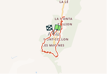
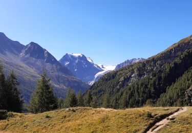
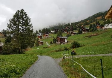
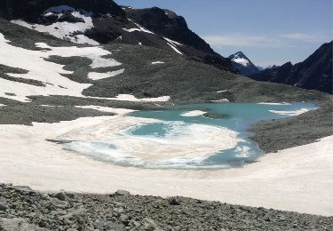
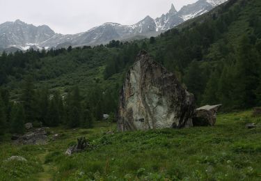
Ruta Senderismo de 7,7 km a descubrir en Vallés, Hérens, Evolène. Esta ruta ha sido propuesta por seghth.
Descripción
Boucle hivernale au depart hotel du Pigne, avec bottines et/ou raquettes, pas toujours bien balisé
Localización
País:
Switzerland
Región :
Vallés
Departamento/provincia :
Hérens
Municipio :
Evolène
Localidad:
Unknown
Salida:(Dec)
Salida:(UTM)
382429 ; 5098040 (32T) N.
Comentarios
Excursiones cerca
![Excursión Senderismo Evolène - Arolla, Cabane des Aiguilles Rouges - Photo](https://media.geolcdn.com/t/375/260/ext.jpg?maxdim=2&url=https%3A%2F%2Fstatic1.geolcdn.com%2Fsiteimages%2Fupload%2Ffiles%2F1553511878bg_sport_marche.png)
![Senderismo Senderismo](https://static1.geolcdn.com/sitytour/trail-icons/101.png)
Arolla, Cabane des Aiguilles Rouges
Senderismo
Muy fácil
(1)
Evolène,
Vallés,
Hérens,
Switzerland
![](/images/other/stat-length.png)
11,8 km | 22 km-effort
6h 30min
![](https://static1.geolcdn.com/siteimages/upload/files/16400158638029165_repeat_loop_refresh_sync_direction_icon.png)
Sí
![Excursión Senderismo Evolène - Arolla – La Sage / Jour 5 - Photo](https://media.geolcdn.com/t/375/260/ext.jpg?maxdim=2&url=https%3A%2F%2Fmedia.geolcdn.com%2Ff%2F23995d09-2bb0-4904-9a8c-4927f08408c0.jpg)
![Senderismo Senderismo](https://static1.geolcdn.com/sitytour/trail-icons/101.png)
Arolla – La Sage / Jour 5
Senderismo
Medio
Evolène,
Vallés,
Hérens,
Switzerland
![](/images/other/stat-length.png)
11,8 km | 19,4 km-effort
3h 18min
![](https://static1.geolcdn.com/siteimages/upload/files/16400158638029165_repeat_loop_refresh_sync_direction_icon.png)
No
![Excursión Senderismo Evolène - CHX ZRMT Étape 6 d'Arolla à La sage - Photo](https://media.geolcdn.com/t/375/260/ext.jpg?maxdim=2&url=https%3A%2F%2Fservices.sitytrail.com%2FGeolivesWS%2FDownloadMedia.ashx%3FTrailID%3D635934%26Media%3Dfix__20160918145302.jpg)
![Senderismo Senderismo](https://static1.geolcdn.com/sitytour/trail-icons/101.png)
CHX ZRMT Étape 6 d'Arolla à La sage
Senderismo
Fácil
Evolène,
Vallés,
Hérens,
Switzerland
![](/images/other/stat-length.png)
17,3 km | 28 km-effort
5h 34min
![](https://static1.geolcdn.com/siteimages/upload/files/16400158638029165_repeat_loop_refresh_sync_direction_icon.png)
No
![Excursión Deportes de invierno Evolène - Verbier/Zermat (Cabane Bertol-Zermatt) - Photo](https://media.geolcdn.com/t/375/260/ext.jpg?maxdim=2&url=https%3A%2F%2Fstatic1.geolcdn.com%2Fsiteimages%2Fupload%2Ffiles%2F1524743153ski.jpg)
![Deportes de invierno Deportes de invierno](https://static1.geolcdn.com/sitytour/trail-icons/500.png)
Verbier/Zermat (Cabane Bertol-Zermatt)
Deportes de invierno
Muy fácil
Evolène,
Vallés,
Hérens,
Switzerland
![](/images/other/stat-length.png)
22 km | 42 km-effort
4h 0min
![](https://static1.geolcdn.com/siteimages/upload/files/16400158638029165_repeat_loop_refresh_sync_direction_icon.png)
No
![Excursión Deportes de invierno Hérémence - Verbier/Zermat (Cabane des Dix-Cabane des Vignettes) - Photo](https://media.geolcdn.com/t/375/260/ext.jpg?maxdim=2&url=https%3A%2F%2Fstatic1.geolcdn.com%2Fsiteimages%2Fupload%2Ffiles%2F1524743153ski.jpg)
![Deportes de invierno Deportes de invierno](https://static1.geolcdn.com/sitytour/trail-icons/500.png)
Verbier/Zermat (Cabane des Dix-Cabane des Vignettes)
Deportes de invierno
Muy fácil
Hérémence,
Vallés,
Hérens,
Switzerland
![](/images/other/stat-length.png)
10,4 km | 26 km-effort
4h 0min
![](https://static1.geolcdn.com/siteimages/upload/files/16400158638029165_repeat_loop_refresh_sync_direction_icon.png)
No
![Excursión Otra actividad Evolène - col du Collon Tour du Cervin - Photo](https://media.geolcdn.com/t/375/260/ext.jpg?maxdim=2&url=https%3A%2F%2Fservices.sitytrail.com%2FGeolivesWS%2FDownloadMedia.ashx%3FTrailID%3D339558%26Media%3D20140824132711.jpg)
![Otra actividad Otra actividad](https://static1.geolcdn.com/sitytour/trail-icons/900.png)
col du Collon Tour du Cervin
Otra actividad
Muy fácil
Evolène,
Vallés,
Hérens,
Switzerland
![](/images/other/stat-length.png)
8,3 km | 18,1 km-effort
4h 39min
![](https://static1.geolcdn.com/siteimages/upload/files/16400158638029165_repeat_loop_refresh_sync_direction_icon.png)
No
![Excursión Senderismo Evolène - vs_hike674c - Photo](https://media.geolcdn.com/t/375/260/ext.jpg?maxdim=2&url=https%3A%2F%2Fstatic1.geolcdn.com%2Fsiteimages%2Fupload%2Ffiles%2F1553511878bg_sport_marche.png)
![Senderismo Senderismo](https://static1.geolcdn.com/sitytour/trail-icons/101.png)
vs_hike674c
Senderismo
Muy fácil
Evolène,
Vallés,
Hérens,
Switzerland
![](/images/other/stat-length.png)
7,5 km | 10,2 km-effort
1h 53min
![](https://static1.geolcdn.com/siteimages/upload/files/16400158638029165_repeat_loop_refresh_sync_direction_icon.png)
No
![Excursión Senderismo Evolène - st_riedmatten - Photo](https://media.geolcdn.com/t/375/260/ext.jpg?maxdim=2&url=https%3A%2F%2Fstatic1.geolcdn.com%2Fsiteimages%2Fupload%2Ffiles%2F1553511878bg_sport_marche.png)
![Senderismo Senderismo](https://static1.geolcdn.com/sitytour/trail-icons/101.png)
st_riedmatten
Senderismo
Muy fácil
Evolène,
Vallés,
Hérens,
Switzerland
![](/images/other/stat-length.png)
16,7 km | 31 km-effort
5h 33min
![](https://static1.geolcdn.com/siteimages/upload/files/16400158638029165_repeat_loop_refresh_sync_direction_icon.png)
No
![Excursión Marcha nórdica Evolène - arola - Photo](https://media.geolcdn.com/t/375/260/ext.jpg?maxdim=2&url=https%3A%2F%2Fmedia.geolcdn.com%2Ff%2Fa4677de7-93dc-428c-9459-0fae1af68501.jpg)
![Marcha nórdica Marcha nórdica](https://static1.geolcdn.com/sitytour/trail-icons/102.png)
arola
Marcha nórdica
Muy fácil
Evolène,
Vallés,
Hérens,
Switzerland
![](/images/other/stat-length.png)
10,2 km | 14,8 km-effort
2h 43min
![](https://static1.geolcdn.com/siteimages/upload/files/16400158638029165_repeat_loop_refresh_sync_direction_icon.png)
No