![](/images/other/stat-length.png)
![Excursión A pie Fléville-devant-Nancy - 2021-02-10_17h14m40_F765 - Photo](https://media.geolcdn.com/t/1900/400/ext.pjpeg?maxdim=2&url=https%3A%2F%2Fstatic1.geolcdn.com%2Fsiteimages%2Fupload%2Ffiles%2F1545311037marcheuse_200dpi.jpg)
2021-02-10_17h14m40_F765
Marin B
Usuario
![Longitud](/images/other/stat-length.png)
Longitud
12,1 km
![Altitud máxima](https://static1.geolcdn.com/siteimages/upload/files/1508320355ic_sort_altitude_max_24dp.png)
Altitud máxima
257 m
![Desnivel positivo](https://static1.geolcdn.com/siteimages/upload/files/1508320355ic_sort_den_pos_24dp.png)
Desnivel positivo
138 m
![Km-Effort](/images/other/stat-length.png)
Km-Effort
13,9 km
![Altitud mínima](https://static1.geolcdn.com/siteimages/upload/files/1508320355ic_sort_altitude_min_24dp.png)
Altitud mínima
205 m
![Desnivel negativo](https://static1.geolcdn.com/siteimages/upload/files/1508320355ic_sort_den_neg_24dp.png)
Desnivel negativo
138 m
![Boucle](https://static1.geolcdn.com/siteimages/upload/files/16400158638029165_repeat_loop_refresh_sync_direction_icon.png)
Boucle
Sí
Fecha de creación :
2021-02-10 16:14:42.792
Última modificación :
2022-02-01 11:07:36.091
![A pie](https://static1.geolcdn.com/sitytour/trail-icons/100.png)
3h10
Dificultad : Fácil
![Senderismo](https://static1.geolcdn.com/sitytour/trail-icons/101.png)
3h10
Dificultad : Fácil
![Escanee este código QR para abrir la excursión en la aplicación SityTrail](https://capi.geolives.com/qq0zvz2zws4bq2lad0pu/sitytour/trails/2666650/qr.png?size=200)
Aplicación GPS de excursión GRATIS
A propósito
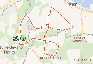
Ruta A pie de 12,1 km a descubrir en Gran Este, Meurthe y Mosela, Fléville-devant-Nancy. Esta ruta ha sido propuesta por Marin B.
Descripción
Parcours facile avec peu de dénivelé,
A faire par temps sec (surtout vers Gérardcourt - boucle évitable
si non)
Localización
País:
France
Región :
Gran Este
Departamento/provincia :
Meurthe y Mosela
Municipio :
Fléville-devant-Nancy
Localidad:
Unknown
Salida:(Dec)
Salida:(UTM)
294606 ; 5389859 (32U) N.
Comentarios
Excursiones cerca
![Excursión A pie Fléville-devant-Nancy - Fléville-devant-Nancy et son château - Photo](https://media.geolcdn.com/t/375/260/ee7686de-cd52-43ca-b6f5-ed4c3a349bb0.jpeg&format=jpg&maxdim=2)
![A pie A pie](https://static1.geolcdn.com/sitytour/trail-icons/100.png)
Fléville-devant-Nancy et son château
A pie
Fácil
Fléville-devant-Nancy,
Gran Este,
Meurthe y Mosela,
France
![](/images/other/stat-length.png)
7,9 km | 9,4 km-effort
2h 8min
![](https://static1.geolcdn.com/siteimages/upload/files/16400158638029165_repeat_loop_refresh_sync_direction_icon.png)
Sí
![Excursión Bici eléctrica Fléville-devant-Nancy - tour dd moselle - Photo](https://media.geolcdn.com/t/375/260/ext.jpg?maxdim=2&url=https%3A%2F%2Fstatic1.geolcdn.com%2Fsiteimages%2Fupload%2Ffiles%2F1524743154velo.jpg)
![Bici eléctrica Bici eléctrica](https://static1.geolcdn.com/sitytour/trail-icons/205.png)
tour dd moselle
Bici eléctrica
Muy fácil
(1)
Fléville-devant-Nancy,
Gran Este,
Meurthe y Mosela,
France
![](/images/other/stat-length.png)
45 km | 55 km-effort
3h 0min
![](https://static1.geolcdn.com/siteimages/upload/files/16400158638029165_repeat_loop_refresh_sync_direction_icon.png)
Sí
![Excursión sport Ludres - Ludres - Photo](https://media.geolcdn.com/t/375/260/4a41c09b-4979-47d6-9e86-ddd52f153625.jpg&format=jpg&maxdim=2)
Ludres
sport
Muy fácil
Ludres,
Gran Este,
Meurthe y Mosela,
France
![](/images/other/stat-length.png)
11,6 km | 14,9 km-effort
Desconocido
![](https://static1.geolcdn.com/siteimages/upload/files/16400158638029165_repeat_loop_refresh_sync_direction_icon.png)
Sí
![Excursión Senderismo Ludres - SityTrail - Marche gourmande 11km - Photo](https://media.geolcdn.com/t/375/260/ext.jpg?maxdim=2&url=https%3A%2F%2Fstatic1.geolcdn.com%2Fsiteimages%2Fupload%2Ffiles%2F1553511878bg_sport_marche.png)
![Senderismo Senderismo](https://static1.geolcdn.com/sitytour/trail-icons/101.png)
SityTrail - Marche gourmande 11km
Senderismo
Difícil
(2)
Ludres,
Gran Este,
Meurthe y Mosela,
France
![](/images/other/stat-length.png)
10,4 km | 12,1 km-effort
2h 45min
![](https://static1.geolcdn.com/siteimages/upload/files/16400158638029165_repeat_loop_refresh_sync_direction_icon.png)
Sí
![Excursión Senderismo Vandœuvre-lès-Nancy - Randonnée USEP 2023 - Photo](https://media.geolcdn.com/t/375/260/ext.jpg?maxdim=2&url=https%3A%2F%2Fstatic1.geolcdn.com%2Fsiteimages%2Fupload%2Ffiles%2F1553511878bg_sport_marche.png)
![Senderismo Senderismo](https://static1.geolcdn.com/sitytour/trail-icons/101.png)
Randonnée USEP 2023
Senderismo
Difícil
(1)
Vandœuvre-lès-Nancy,
Gran Este,
Meurthe y Mosela,
France
![](/images/other/stat-length.png)
11,7 km | 15,2 km-effort
3h 27min
![](https://static1.geolcdn.com/siteimages/upload/files/16400158638029165_repeat_loop_refresh_sync_direction_icon.png)
No
![Excursión Senderismo Ludres - marche nuit - Photo](https://media.geolcdn.com/t/375/260/2c15af7e-0536-4068-be2b-216477912337.jpg&format=jpg&maxdim=2)
![Senderismo Senderismo](https://static1.geolcdn.com/sitytour/trail-icons/101.png)
marche nuit
Senderismo
Medio
Ludres,
Gran Este,
Meurthe y Mosela,
France
![](/images/other/stat-length.png)
8,7 km | 10,1 km-effort
2h 11min
![](https://static1.geolcdn.com/siteimages/upload/files/16400158638029165_repeat_loop_refresh_sync_direction_icon.png)
Sí
![Excursión Marcha nórdica Ludres - Randonnée Ludres la mine la maison Patrick et Nini - Photo](https://media.geolcdn.com/t/375/260/2aa95365-fabd-4569-b6c7-48b029e99a55.jpg&format=jpg&maxdim=2)
![Marcha nórdica Marcha nórdica](https://static1.geolcdn.com/sitytour/trail-icons/102.png)
Randonnée Ludres la mine la maison Patrick et Nini
Marcha nórdica
Fácil
Ludres,
Gran Este,
Meurthe y Mosela,
France
![](/images/other/stat-length.png)
6,7 km | 8,4 km-effort
1h 48min
![](https://static1.geolcdn.com/siteimages/upload/files/16400158638029165_repeat_loop_refresh_sync_direction_icon.png)
No
![Excursión Marcha nórdica Ludres - Randonnée Ludres Belvédère - Photo](https://media.geolcdn.com/t/375/260/e4a847d5-4f8b-43b2-8f0d-49e66642522d.jpg&format=jpg&maxdim=2)
![Marcha nórdica Marcha nórdica](https://static1.geolcdn.com/sitytour/trail-icons/102.png)
Randonnée Ludres Belvédère
Marcha nórdica
Fácil
Ludres,
Gran Este,
Meurthe y Mosela,
France
![](/images/other/stat-length.png)
6,7 km | 8 km-effort
1h 44min
![](https://static1.geolcdn.com/siteimages/upload/files/16400158638029165_repeat_loop_refresh_sync_direction_icon.png)
Sí
![Excursión Senderismo Vandœuvre-lès-Nancy - Ludres 12 500m +178m - Photo](https://media.geolcdn.com/t/375/260/ext.jpg?maxdim=2&url=https%3A%2F%2Fservices.sitytrail.com%2FGeolivesWS%2FDownloadMedia.ashx%3FTrailID%3D796591%26Media%3Dfix__20170726160233.jpg)
![Senderismo Senderismo](https://static1.geolcdn.com/sitytour/trail-icons/101.png)
Ludres 12 500m +178m
Senderismo
Muy fácil
Vandœuvre-lès-Nancy,
Gran Este,
Meurthe y Mosela,
France
![](/images/other/stat-length.png)
12,3 km | 14,5 km-effort
3h 14min
![](https://static1.geolcdn.com/siteimages/upload/files/16400158638029165_repeat_loop_refresh_sync_direction_icon.png)
Sí