![](/images/other/stat-length.png)
![Excursión Senderismo Bézaudun-sur-Bîne - 20210204_grandDelmas - Photo](https://media.geolcdn.com/t/1900/400/ext.pjpeg?maxdim=2&url=https%3A%2F%2Fstatic1.geolcdn.com%2Fsiteimages%2Fupload%2Ffiles%2F1553511878bg_sport_marche.png)
20210204_grandDelmas
ajd26
Usuario
![Longitud](/images/other/stat-length.png)
Longitud
12,9 km
![Altitud máxima](https://static1.geolcdn.com/siteimages/upload/files/1508320355ic_sort_altitude_max_24dp.png)
Altitud máxima
1516 m
![Desnivel positivo](https://static1.geolcdn.com/siteimages/upload/files/1508320355ic_sort_den_pos_24dp.png)
Desnivel positivo
770 m
![Km-Effort](/images/other/stat-length.png)
Km-Effort
23 km
![Altitud mínima](https://static1.geolcdn.com/siteimages/upload/files/1508320355ic_sort_altitude_min_24dp.png)
Altitud mínima
832 m
![Desnivel negativo](https://static1.geolcdn.com/siteimages/upload/files/1508320355ic_sort_den_neg_24dp.png)
Desnivel negativo
768 m
![Boucle](https://static1.geolcdn.com/siteimages/upload/files/16400158638029165_repeat_loop_refresh_sync_direction_icon.png)
Boucle
Sí
Fecha de creación :
2021-02-06 15:51:58.363
Última modificación :
2021-02-06 16:14:04.45
![Senderismo](https://static1.geolcdn.com/sitytour/trail-icons/101.png)
4h20
Dificultad : Medio
![Escanee este código QR para abrir la excursión en la aplicación SityTrail](https://capi.geolives.com/qq0zvz2zws4bq2lad0pu/sitytour/trails/2662466/qr.png?size=200)
Aplicación GPS de excursión GRATIS
A propósito
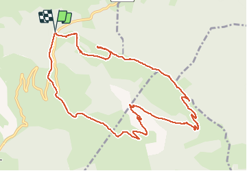
Ruta Senderismo de 12,9 km a descubrir en Auvergne-Rhône-Alpes, Drôme, Bézaudun-sur-Bîne. Esta ruta ha sido propuesta por ajd26.
Descripción
effectuée le 04/02/2021
départ du col de Gourdon, direction les Tonils, le pré du Boeuf, Grand Delmas, la Grazonnière et retour par la Fontaine Froide
Localización
País:
France
Región :
Auvergne-Rhône-Alpes
Departamento/provincia :
Drôme
Municipio :
Bézaudun-sur-Bîne
Localidad:
Unknown
Salida:(Dec)
Salida:(UTM)
673213 ; 4943028 (31T) N.
Comentarios
Excursiones cerca
![Excursión Senderismo Bourdeaux - Chemin des protestants- Bourdaux - Photo](https://media.geolcdn.com/t/375/260/c9690b91-aa42-47d0-b809-97d643432899.jpg&format=jpg&maxdim=2)
![Senderismo Senderismo](https://static1.geolcdn.com/sitytour/trail-icons/101.png)
Chemin des protestants- Bourdaux
Senderismo
Medio
(1)
Bourdeaux,
Auvergne-Rhône-Alpes,
Drôme,
France
![](/images/other/stat-length.png)
7,9 km | 11,2 km-effort
2h 48min
![](https://static1.geolcdn.com/siteimages/upload/files/16400158638029165_repeat_loop_refresh_sync_direction_icon.png)
Sí
![Excursión Senderismo Saou - saou.les 3 becs - Photo](https://media.geolcdn.com/t/375/260/ext.jpg?maxdim=2&url=https%3A%2F%2Fservices.sitytrail.com%2FGeolivesWS%2FDownloadMedia.ashx%3FTrailID%3D329039%26Media%3Dfix__20140719140834.jpg)
![Senderismo Senderismo](https://static1.geolcdn.com/sitytour/trail-icons/101.png)
saou.les 3 becs
Senderismo
Difícil
(3)
Saou,
Auvergne-Rhône-Alpes,
Drôme,
France
![](/images/other/stat-length.png)
22 km | 40 km-effort
6h 46min
![](https://static1.geolcdn.com/siteimages/upload/files/16400158638029165_repeat_loop_refresh_sync_direction_icon.png)
Sí
![Excursión Senderismo La Chaudière - Les 3 Becs - Photo](https://media.geolcdn.com/t/375/260/ext.jpg?maxdim=2&url=https%3A%2F%2Fservices.sitytrail.com%2FGeolivesWS%2FDownloadMedia.ashx%3FTrailID%3D218224%26Media%3Dfix__20130901120821.jpg)
![Senderismo Senderismo](https://static1.geolcdn.com/sitytour/trail-icons/101.png)
Les 3 Becs
Senderismo
Medio
(1)
La Chaudière,
Auvergne-Rhône-Alpes,
Drôme,
France
![](/images/other/stat-length.png)
10,3 km | 21 km-effort
5h 37min
![](https://static1.geolcdn.com/siteimages/upload/files/16400158638029165_repeat_loop_refresh_sync_direction_icon.png)
Sí
![Excursión Senderismo La Chaudière - La chaudiere - chapelle des Sadoux - Photo](https://media.geolcdn.com/t/375/260/fe29fe3e-8696-4fc7-af92-f6d3eeb26877.jpg&format=jpg&maxdim=2)
![Senderismo Senderismo](https://static1.geolcdn.com/sitytour/trail-icons/101.png)
La chaudiere - chapelle des Sadoux
Senderismo
Muy fácil
(2)
La Chaudière,
Auvergne-Rhône-Alpes,
Drôme,
France
![](/images/other/stat-length.png)
11,1 km | 18,2 km-effort
3h 47min
![](https://static1.geolcdn.com/siteimages/upload/files/16400158638029165_repeat_loop_refresh_sync_direction_icon.png)
Sí
![Excursión Senderismo Saou - Les 3 Becs, le Veyou, le Signal et Rochecourbe - Photo](https://media.geolcdn.com/t/375/260/ext.jpg?maxdim=2&url=https%3A%2F%2Fservices.sitytrail.com%2FGeolivesWS%2FDownloadMedia.ashx%3FTrailID%3D103158%26Media%3D4975_2.jpg)
![Senderismo Senderismo](https://static1.geolcdn.com/sitytour/trail-icons/101.png)
Les 3 Becs, le Veyou, le Signal et Rochecourbe
Senderismo
Difícil
(3)
Saou,
Auvergne-Rhône-Alpes,
Drôme,
France
![](/images/other/stat-length.png)
18,5 km | 36 km-effort
8h 0min
![](https://static1.geolcdn.com/siteimages/upload/files/16400158638029165_repeat_loop_refresh_sync_direction_icon.png)
Sí
![Excursión Senderismo Mornans - 2024-11-19_11h34m34_FFRandonnée-Serre_Antoine - Photo](https://media.geolcdn.com/t/375/260/aebe72e3-9e3b-4ceb-b487-16517306d02c.jpg&format=jpg&maxdim=2)
![Senderismo Senderismo](https://static1.geolcdn.com/sitytour/trail-icons/101.png)
2024-11-19_11h34m34_FFRandonnée-Serre_Antoine
Senderismo
Difícil
Mornans,
Auvergne-Rhône-Alpes,
Drôme,
France
![](/images/other/stat-length.png)
11,4 km | 17,4 km-effort
3h 57min
![](https://static1.geolcdn.com/siteimages/upload/files/16400158638029165_repeat_loop_refresh_sync_direction_icon.png)
Sí
![Excursión Senderismo Bézaudun-sur-Bîne - 2022-09-26_14h18m42_12295156 - Photo](https://media.geolcdn.com/t/375/260/f11da23a-0048-4e80-a120-e8dd7afb6f22.jpg&format=jpg&maxdim=2)
![Senderismo Senderismo](https://static1.geolcdn.com/sitytour/trail-icons/101.png)
2022-09-26_14h18m42_12295156
Senderismo
Medio
Bézaudun-sur-Bîne,
Auvergne-Rhône-Alpes,
Drôme,
France
![](/images/other/stat-length.png)
6,1 km | 9,9 km-effort
2h 14min
![](https://static1.geolcdn.com/siteimages/upload/files/16400158638029165_repeat_loop_refresh_sync_direction_icon.png)
Sí
![Excursión Bici de carretera Mornans - Col de Chaudiere, Saillans, Col de muse, Crupies - Photo](https://media.geolcdn.com/t/375/260/b8fcd270-be8e-430a-92ee-e05ed8f76209.jpg&format=jpg&maxdim=2)
![Bici de carretera Bici de carretera](https://static1.geolcdn.com/sitytour/trail-icons/201.png)
Col de Chaudiere, Saillans, Col de muse, Crupies
Bici de carretera
Difícil
Mornans,
Auvergne-Rhône-Alpes,
Drôme,
France
![](/images/other/stat-length.png)
80 km | 105 km-effort
4h 27min
![](https://static1.geolcdn.com/siteimages/upload/files/16400158638029165_repeat_loop_refresh_sync_direction_icon.png)
Sí
![Excursión Senderismo La Chaudière - les 3becs et arches - Photo](https://media.geolcdn.com/t/375/260/97464636-1260-4d97-b592-83a9cda2a983.jpg&format=jpg&maxdim=2)
![Senderismo Senderismo](https://static1.geolcdn.com/sitytour/trail-icons/101.png)
les 3becs et arches
Senderismo
Difícil
La Chaudière,
Auvergne-Rhône-Alpes,
Drôme,
France
![](/images/other/stat-length.png)
15,3 km | 31 km-effort
5h 10min
![](https://static1.geolcdn.com/siteimages/upload/files/16400158638029165_repeat_loop_refresh_sync_direction_icon.png)
Sí