![](/images/other/stat-length.png)
![Excursión A pie Oberhaslach - 24/01/21- Cascade Nideck et château par la M.F - Photo](https://media.geolcdn.com/t/1900/400/ext.pjpeg?maxdim=2&url=https%3A%2F%2Fstatic1.geolcdn.com%2Fsiteimages%2Fupload%2Ffiles%2F1545311037marcheuse_200dpi.jpg)
24/01/21- Cascade Nideck et château par la M.F
delm
Usuario
![Longitud](/images/other/stat-length.png)
Longitud
6,1 km
![Altitud máxima](https://static1.geolcdn.com/siteimages/upload/files/1508320355ic_sort_altitude_max_24dp.png)
Altitud máxima
619 m
![Desnivel positivo](https://static1.geolcdn.com/siteimages/upload/files/1508320355ic_sort_den_pos_24dp.png)
Desnivel positivo
288 m
![Km-Effort](/images/other/stat-length.png)
Km-Effort
9,9 km
![Altitud mínima](https://static1.geolcdn.com/siteimages/upload/files/1508320355ic_sort_altitude_min_24dp.png)
Altitud mínima
347 m
![Desnivel negativo](https://static1.geolcdn.com/siteimages/upload/files/1508320355ic_sort_den_neg_24dp.png)
Desnivel negativo
286 m
![Boucle](https://static1.geolcdn.com/siteimages/upload/files/16400158638029165_repeat_loop_refresh_sync_direction_icon.png)
Boucle
Sí
Fecha de creación :
2021-01-23 09:26:50.585
Última modificación :
2021-01-24 17:15:34.157
![A pie](https://static1.geolcdn.com/sitytour/trail-icons/100.png)
--
Dificultad : Muy fácil
![Escanee este código QR para abrir la excursión en la aplicación SityTrail](https://capi.geolives.com/qq0zvz2zws4bq2lad0pu/sitytour/trails/2648152/qr.png?size=200)
Aplicación GPS de excursión GRATIS
A propósito
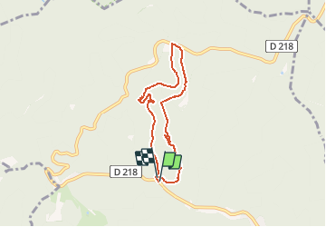
Ruta A pie de 6,1 km a descubrir en Gran Este, Bajo-Rin, Oberhaslach. Esta ruta ha sido propuesta por delm.
Descripción
Randonnée agréable et sympathique
Quelques petites montées raide au départ.
Facile -moyen
6,870 Km
Effectuée en 2 h 30
Localización
País:
France
Región :
Gran Este
Departamento/provincia :
Bajo-Rin
Municipio :
Oberhaslach
Localidad:
Unknown
Salida:(Dec)
Salida:(UTM)
373587 ; 5380988 (32U) N.
Comentarios
Excursiones cerca
![Excursión Senderismo Urmatt - Cascade Soultzbach - Urmatt - Photo](https://media.geolcdn.com/t/375/260/20e7652d-0a73-4a1a-a692-b5e1164e2be3.jpg&format=jpg&maxdim=2)
![Senderismo Senderismo](https://static1.geolcdn.com/sitytour/trail-icons/101.png)
Cascade Soultzbach - Urmatt
Senderismo
Muy difícil
(1)
Urmatt,
Gran Este,
Bajo-Rin,
France
![](/images/other/stat-length.png)
14,9 km | 21 km-effort
4h 46min
![](https://static1.geolcdn.com/siteimages/upload/files/16400158638029165_repeat_loop_refresh_sync_direction_icon.png)
Sí
![Excursión Paseo ecuestre Oberhaslach - Neufeld Boucle Elmersforst - Photo](https://media.geolcdn.com/t/375/260/ext.jpg?maxdim=2&url=https%3A%2F%2Fstatic1.geolcdn.com%2Fsiteimages%2Fupload%2Ffiles%2F1524743154cheval.jpg)
![Paseo ecuestre Paseo ecuestre](https://static1.geolcdn.com/sitytour/trail-icons/301.png)
Neufeld Boucle Elmersforst
Paseo ecuestre
Difícil
(1)
Oberhaslach,
Gran Este,
Bajo-Rin,
France
![](/images/other/stat-length.png)
31 km | 42 km-effort
5h 9min
![](https://static1.geolcdn.com/siteimages/upload/files/16400158638029165_repeat_loop_refresh_sync_direction_icon.png)
Sí
![Excursión Senderismo Lutzelhouse - 2013-05-10 Marche Rocher de Mutzig par Nideck - Photo](https://media.geolcdn.com/t/375/260/ext.jpg?maxdim=2&url=https%3A%2F%2Fstatic1.geolcdn.com%2Fsiteimages%2Fupload%2Ffiles%2F1553511878bg_sport_marche.png)
![Senderismo Senderismo](https://static1.geolcdn.com/sitytour/trail-icons/101.png)
2013-05-10 Marche Rocher de Mutzig par Nideck
Senderismo
Medio
(1)
Lutzelhouse,
Gran Este,
Bajo-Rin,
France
![](/images/other/stat-length.png)
14,9 km | 24 km-effort
4h 10min
![](https://static1.geolcdn.com/siteimages/upload/files/16400158638029165_repeat_loop_refresh_sync_direction_icon.png)
Sí
![Excursión Bici de montaña Niederhaslach - Guirbaden - Grendelbruch - Photo](https://media.geolcdn.com/t/375/260/ext.jpg?maxdim=2&url=https%3A%2F%2Fservices.sitytrail.com%2FGeolivesWS%2FDownloadMedia.ashx%3FTrailID%3D103277%26Media%3D5231_1.jpg)
![Bici de montaña Bici de montaña](https://static1.geolcdn.com/sitytour/trail-icons/202.png)
Guirbaden - Grendelbruch
Bici de montaña
Difícil
(1)
Niederhaslach,
Gran Este,
Bajo-Rin,
France
![](/images/other/stat-length.png)
26 km | 35 km-effort
2h 30min
![](https://static1.geolcdn.com/siteimages/upload/files/16400158638029165_repeat_loop_refresh_sync_direction_icon.png)
No
![Excursión Bici de montaña Oberhaslach - Rando des Feuilles Mortes - Photo](https://media.geolcdn.com/t/375/260/ext.jpg?maxdim=2&url=https%3A%2F%2Fservices.sitytrail.com%2FGeolivesWS%2FDownloadMedia.ashx%3FTrailID%3D101060%26Media%3D551_1.jpg)
![Bici de montaña Bici de montaña](https://static1.geolcdn.com/sitytour/trail-icons/202.png)
Rando des Feuilles Mortes
Bici de montaña
Medio
(2)
Oberhaslach,
Gran Este,
Bajo-Rin,
France
![](/images/other/stat-length.png)
29 km | 41 km-effort
2h 0min
![](https://static1.geolcdn.com/siteimages/upload/files/16400158638029165_repeat_loop_refresh_sync_direction_icon.png)
Sí
![Excursión Paseo ecuestre Niederhaslach - Toutes fugues - Photo](https://media.geolcdn.com/t/375/260/ext.jpg?maxdim=2&url=https%3A%2F%2Fstatic1.geolcdn.com%2Fsiteimages%2Fupload%2Ffiles%2F1524743154cheval.jpg)
![Paseo ecuestre Paseo ecuestre](https://static1.geolcdn.com/sitytour/trail-icons/301.png)
Toutes fugues
Paseo ecuestre
Fácil
(1)
Niederhaslach,
Gran Este,
Bajo-Rin,
France
![](/images/other/stat-length.png)
29 km | 39 km-effort
Desconocido
![](https://static1.geolcdn.com/siteimages/upload/files/16400158638029165_repeat_loop_refresh_sync_direction_icon.png)
Sí
![Excursión Paseo ecuestre Still - 2022-07-10 Picnic CVA Umwurf depuis Oberhaslach - Photo](https://media.geolcdn.com/t/375/260/345719c4-c8c7-4272-8b46-e89c45a30cba.jpg&format=jpg&maxdim=2)
![Paseo ecuestre Paseo ecuestre](https://static1.geolcdn.com/sitytour/trail-icons/301.png)
2022-07-10 Picnic CVA Umwurf depuis Oberhaslach
Paseo ecuestre
Difícil
Still,
Gran Este,
Bajo-Rin,
France
![](/images/other/stat-length.png)
28 km | 40 km-effort
5h 53min
![](https://static1.geolcdn.com/siteimages/upload/files/16400158638029165_repeat_loop_refresh_sync_direction_icon.png)
Sí
![Excursión Senderismo Dabo - 2020-06-01 Marche Hengst - Photo](https://media.geolcdn.com/t/375/260/188abe8d-f41e-44e5-a426-fbd2513d6d58.jpg&format=jpg&maxdim=2)
![Senderismo Senderismo](https://static1.geolcdn.com/sitytour/trail-icons/101.png)
2020-06-01 Marche Hengst
Senderismo
Muy fácil
Dabo,
Gran Este,
Mosela,
France
![](/images/other/stat-length.png)
13,8 km | 18,7 km-effort
4h 18min
![](https://static1.geolcdn.com/siteimages/upload/files/16400158638029165_repeat_loop_refresh_sync_direction_icon.png)
Sí
![Excursión Senderismo Wangenbourg-Engenthal - 2019-11-16 Marche Wangenbourg Castelberg - Photo](https://media.geolcdn.com/t/375/260/5fe565fb-6e88-4bed-a889-a75a33bb061a.jpg&format=jpg&maxdim=2)
![Senderismo Senderismo](https://static1.geolcdn.com/sitytour/trail-icons/101.png)
2019-11-16 Marche Wangenbourg Castelberg
Senderismo
Muy fácil
Wangenbourg-Engenthal,
Gran Este,
Bajo-Rin,
France
![](/images/other/stat-length.png)
19,8 km | 31 km-effort
4h 51min
![](https://static1.geolcdn.com/siteimages/upload/files/16400158638029165_repeat_loop_refresh_sync_direction_icon.png)
Sí