![](/images/other/stat-length.png)
![Excursión Esquí de fondo Beaufort - Outray depuis Plan Bozon - Photo](https://media.geolcdn.com/t/1900/400/99e756e9-2e80-4001-b783-24923e24fdac.jpg&format=pjpeg&maxdim=2)
Outray depuis Plan Bozon
bill73
Usuario
![Longitud](/images/other/stat-length.png)
Longitud
11,7 km
![Altitud máxima](https://static1.geolcdn.com/siteimages/upload/files/1508320355ic_sort_altitude_max_24dp.png)
Altitud máxima
2142 m
![Desnivel positivo](https://static1.geolcdn.com/siteimages/upload/files/1508320355ic_sort_den_pos_24dp.png)
Desnivel positivo
1157 m
![Km-Effort](/images/other/stat-length.png)
Km-Effort
27 km
![Altitud mínima](https://static1.geolcdn.com/siteimages/upload/files/1508320355ic_sort_altitude_min_24dp.png)
Altitud mínima
972 m
![Desnivel negativo](https://static1.geolcdn.com/siteimages/upload/files/1508320355ic_sort_den_neg_24dp.png)
Desnivel negativo
1154 m
![Boucle](https://static1.geolcdn.com/siteimages/upload/files/16400158638029165_repeat_loop_refresh_sync_direction_icon.png)
Boucle
Sí
Fecha de creación :
2021-01-16 09:41:13.069
Última modificación :
2021-01-16 12:58:35.713
![Esquí de fondo](https://static1.geolcdn.com/sitytour/trail-icons/503.png)
2h32
Dificultad : Muy fácil
![Escanee este código QR para abrir la excursión en la aplicación SityTrail](https://capi.geolives.com/qq0zvz2zws4bq2lad0pu/sitytour/trails/2642222/qr.png?size=200)
Aplicación GPS de excursión GRATIS
A propósito
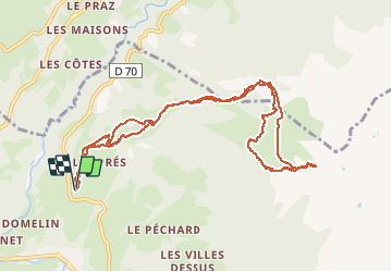
Ruta Esquí de fondo de 11,7 km a descubrir en Auvergne-Rhône-Alpes, Saboya, Beaufort. Esta ruta ha sido propuesta por bill73.
Descripción
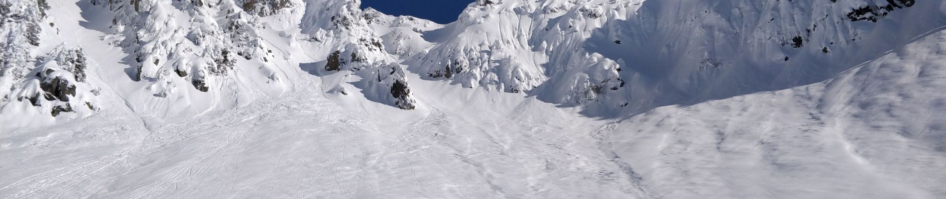
Départ depuis chez Alexandra, beaucoup de neige monté jusqu'au dernier virage à gauche avant le pas, poudreuse magnifique.
Rencontré Bruno Brun et son fils qui ont fait une partie de la trace.
Localización
País:
France
Región :
Auvergne-Rhône-Alpes
Departamento/provincia :
Saboya
Municipio :
Beaufort
Localidad:
Unknown
Salida:(Dec)
Salida:(UTM)
311297 ; 5066598 (32T) N.
Comentarios
Excursiones cerca
![Excursión Senderismo Hauteluce - sous Bisanne au lac des Saisies - Photo](https://media.geolcdn.com/t/375/260/37326f22-0206-4f0e-b1e9-16790c9e91ab.jpg&format=jpg&maxdim=2)
![Senderismo Senderismo](https://static1.geolcdn.com/sitytour/trail-icons/101.png)
sous Bisanne au lac des Saisies
Senderismo
Medio
(1)
Hauteluce,
Auvergne-Rhône-Alpes,
Saboya,
France
![](/images/other/stat-length.png)
18,1 km | 28 km-effort
5h 36min
![](https://static1.geolcdn.com/siteimages/upload/files/16400158638029165_repeat_loop_refresh_sync_direction_icon.png)
Sí
![Excursión Bicicleta Villard-sur-Doron - Boucle Villars le Mont Crest Voland Les Saisies - Photo](https://media.geolcdn.com/t/375/260/ext.jpg?maxdim=2&url=https%3A%2F%2Fservices.sitytrail.com%2FGeolivesWS%2FDownloadMedia.ashx%3FTrailID%3D855162%26Media%3D20171031161248.jpg)
![Bicicleta Bicicleta](https://static1.geolcdn.com/sitytour/trail-icons/200.png)
Boucle Villars le Mont Crest Voland Les Saisies
Bicicleta
Difícil
(1)
Villard-sur-Doron,
Auvergne-Rhône-Alpes,
Saboya,
France
![](/images/other/stat-length.png)
49 km | 74 km-effort
3h 42min
![](https://static1.geolcdn.com/siteimages/upload/files/16400158638029165_repeat_loop_refresh_sync_direction_icon.png)
Sí
![Excursión Senderismo Beaufort - D'Arêches au Col de Pré par le hameau de Boudin - Photo](https://media.geolcdn.com/t/375/260/ext.jpg?maxdim=2&url=https%3A%2F%2Fservices.sitytrail.com%2FGeolivesWS%2FDownloadMedia.ashx%3FTrailID%3D112688%26Media%3D11533_5.jpg)
![Senderismo Senderismo](https://static1.geolcdn.com/sitytour/trail-icons/101.png)
D'Arêches au Col de Pré par le hameau de Boudin
Senderismo
Medio
(1)
Beaufort,
Auvergne-Rhône-Alpes,
Saboya,
France
![](/images/other/stat-length.png)
8,2 km | 17,9 km-effort
4h 0min
![](https://static1.geolcdn.com/siteimages/upload/files/16400158638029165_repeat_loop_refresh_sync_direction_icon.png)
Sí
![Excursión Senderismo Beaufort - Arêches Cuvy - Photo](https://media.geolcdn.com/t/375/260/ext.jpg?maxdim=2&url=https%3A%2F%2Fstatic1.geolcdn.com%2Fsiteimages%2Fupload%2Ffiles%2F1553511878bg_sport_marche.png)
![Senderismo Senderismo](https://static1.geolcdn.com/sitytour/trail-icons/101.png)
Arêches Cuvy
Senderismo
Medio
(1)
Beaufort,
Auvergne-Rhône-Alpes,
Saboya,
France
![](/images/other/stat-length.png)
7,1 km | 13,9 km-effort
2h 36min
![](https://static1.geolcdn.com/siteimages/upload/files/16400158638029165_repeat_loop_refresh_sync_direction_icon.png)
No
![Excursión Esquí de fondo Hauteluce - Rocher des enclaves et montagne d'outray - Photo](https://media.geolcdn.com/t/375/260/022bbe64-5535-472f-aeaf-83ac5e47988e.jpg&format=jpg&maxdim=2)
![Esquí de fondo Esquí de fondo](https://static1.geolcdn.com/sitytour/trail-icons/503.png)
Rocher des enclaves et montagne d'outray
Esquí de fondo
Medio
Hauteluce,
Auvergne-Rhône-Alpes,
Saboya,
France
![](/images/other/stat-length.png)
14 km | 33 km-effort
6h 4min
![](https://static1.geolcdn.com/siteimages/upload/files/16400158638029165_repeat_loop_refresh_sync_direction_icon.png)
Sí
![Excursión Esquí de fondo Beaufort - Côte 2000 et col de Roche plane - Photo](https://media.geolcdn.com/t/375/260/38a11e49-5450-4382-89d2-44ae6ea43162.jpg&format=jpg&maxdim=2)
![Esquí de fondo Esquí de fondo](https://static1.geolcdn.com/sitytour/trail-icons/503.png)
Côte 2000 et col de Roche plane
Esquí de fondo
Fácil
Beaufort,
Auvergne-Rhône-Alpes,
Saboya,
France
![](/images/other/stat-length.png)
12,5 km | 29 km-effort
6h 46min
![](https://static1.geolcdn.com/siteimages/upload/files/16400158638029165_repeat_loop_refresh_sync_direction_icon.png)
Sí
![Excursión Senderismo Hauteluce - Hauteluce - Photo](https://media.geolcdn.com/t/375/260/ext.jpg?maxdim=2&url=https%3A%2F%2Fstatic1.geolcdn.com%2Fsiteimages%2Fupload%2Ffiles%2F1553511878bg_sport_marche.png)
![Senderismo Senderismo](https://static1.geolcdn.com/sitytour/trail-icons/101.png)
Hauteluce
Senderismo
Muy fácil
(2)
Hauteluce,
Auvergne-Rhône-Alpes,
Saboya,
France
![](/images/other/stat-length.png)
4,1 km | 7,4 km-effort
1h 54min
![](https://static1.geolcdn.com/siteimages/upload/files/16400158638029165_repeat_loop_refresh_sync_direction_icon.png)
Sí
![Excursión Senderismo Hauteluce - Mont Clocher - Photo](https://media.geolcdn.com/t/375/260/ext.jpg?maxdim=2&url=https%3A%2F%2Fservices.sitytrail.com%2FGeolivesWS%2FDownloadMedia.ashx%3FTrailID%3D85242%26Media%3D20110903163145.jpg)
![Senderismo Senderismo](https://static1.geolcdn.com/sitytour/trail-icons/101.png)
Mont Clocher
Senderismo
Muy fácil
(2)
Hauteluce,
Auvergne-Rhône-Alpes,
Saboya,
France
![](/images/other/stat-length.png)
7,3 km | 10,4 km-effort
1h 47min
![](https://static1.geolcdn.com/siteimages/upload/files/16400158638029165_repeat_loop_refresh_sync_direction_icon.png)
Sí
![Excursión Senderismo Beaufort - Le pas de l’âne 10 km 850 m dénivelé + - Photo](https://media.geolcdn.com/t/375/260/e16223c0-d24b-4318-beff-cfc74b9fa02c.jpg&format=jpg&maxdim=2)
![Senderismo Senderismo](https://static1.geolcdn.com/sitytour/trail-icons/101.png)
Le pas de l’âne 10 km 850 m dénivelé +
Senderismo
Medio
Beaufort,
Auvergne-Rhône-Alpes,
Saboya,
France
![](/images/other/stat-length.png)
10,2 km | 21 km-effort
7h 59min
![](https://static1.geolcdn.com/siteimages/upload/files/16400158638029165_repeat_loop_refresh_sync_direction_icon.png)
Sí