![](/images/other/stat-length.png)
![Excursión Senderismo Saint-Jean-le-Vieux - La Poya - Photo](https://media.geolcdn.com/t/1900/400/8a35063f-962f-447c-bf8c-317aafa73c11.jpg&format=pjpeg&maxdim=2)
La Poya
flip38
Usuario
![Longitud](/images/other/stat-length.png)
![Altitud máxima](https://static1.geolcdn.com/siteimages/upload/files/1508320355ic_sort_altitude_max_24dp.png)
![Desnivel positivo](https://static1.geolcdn.com/siteimages/upload/files/1508320355ic_sort_den_pos_24dp.png)
![Km-Effort](/images/other/stat-length.png)
![Altitud mínima](https://static1.geolcdn.com/siteimages/upload/files/1508320355ic_sort_altitude_min_24dp.png)
![Desnivel negativo](https://static1.geolcdn.com/siteimages/upload/files/1508320355ic_sort_den_neg_24dp.png)
![Boucle](https://static1.geolcdn.com/siteimages/upload/files/16400158638029165_repeat_loop_refresh_sync_direction_icon.png)
![Senderismo](https://static1.geolcdn.com/sitytour/trail-icons/101.png)
2h49
Dificultad : Fácil
![Escanee este código QR para abrir la excursión en la aplicación SityTrail](https://capi.geolives.com/qq0zvz2zws4bq2lad0pu/sitytour/trails/2621485/qr.png?size=200)
Aplicación GPS de excursión GRATIS
A propósito
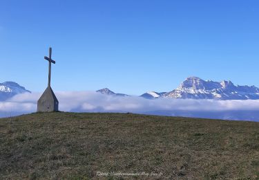
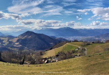
Ruta Senderismo de 9,7 km a descubrir en Auvergne-Rhône-Alpes, Isère, Saint-Jean-le-Vieux. Esta ruta ha sido propuesta por flip38.
Descripción
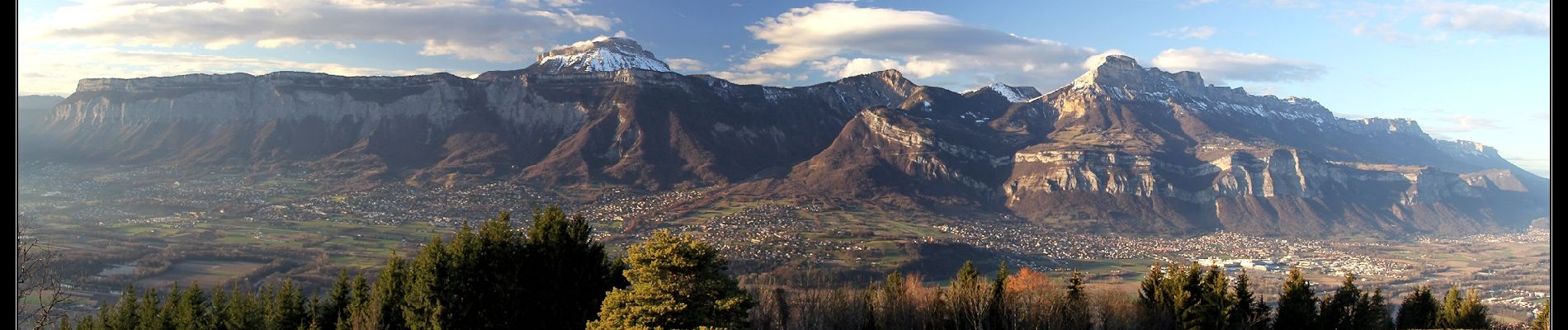
Départ du parking de l'église de Saint-Jean-le-Vieux pour une petite boucle agréable et en grande partie en forêt, mais aussi quelques beaux points de vue. Le petit sommet de la Poya est très panoramique pour admirer la Chartreuse, Belledonne et la vallée du Grésivaudan.
Certaines parties peuvent être un peu grasses par temps humide.
Localización
Comentarios
Excursiones cerca
![Excursión A pie La Combe-de-Lancey - Chemin de Découverte (boucle Basse) - Photo](https://media.geolcdn.com/t/375/260/6915f95f-b034-4e84-88aa-9ed85af7f443.jpeg&format=jpg&maxdim=2)
![A pie A pie](https://static1.geolcdn.com/sitytour/trail-icons/100.png)
A pie
![](/images/other/stat-length.png)
![](https://static1.geolcdn.com/siteimages/upload/files/16400158638029165_repeat_loop_refresh_sync_direction_icon.png)
![Excursión A pie La Combe-de-Lancey - Chemin de Découverte (boucle Haute) - Photo](https://media.geolcdn.com/t/375/260/6a0cb0d1-93da-4068-99ad-9a549161cacf.jpeg&format=jpg&maxdim=2)
![A pie A pie](https://static1.geolcdn.com/sitytour/trail-icons/100.png)
A pie
![](/images/other/stat-length.png)
![](https://static1.geolcdn.com/siteimages/upload/files/16400158638029165_repeat_loop_refresh_sync_direction_icon.png)
![Excursión A pie Domène - Domène à Murianette, par les rives de l'Isère - Photo](https://media.geolcdn.com/t/375/260/f00f3b3d-abcc-47f4-9cc6-e5ee52a8ddd2.jpeg&format=jpg&maxdim=2)
![A pie A pie](https://static1.geolcdn.com/sitytour/trail-icons/100.png)
A pie
![](/images/other/stat-length.png)
![](https://static1.geolcdn.com/siteimages/upload/files/16400158638029165_repeat_loop_refresh_sync_direction_icon.png)
![Excursión A pie Domène - Circuit de Beauregard - Photo](https://media.geolcdn.com/t/375/260/c0d86b6a-ec41-4f3c-879d-1fb6f4151878.jpeg&format=jpg&maxdim=2)
![A pie A pie](https://static1.geolcdn.com/sitytour/trail-icons/100.png)
A pie
![](/images/other/stat-length.png)
![](https://static1.geolcdn.com/siteimages/upload/files/16400158638029165_repeat_loop_refresh_sync_direction_icon.png)
![Excursión A pie Domène - Circuit de la Monta - Photo](https://media.geolcdn.com/t/375/260/8f502881-e98d-4929-b19b-6c8e9cb279e5.jpeg&format=jpg&maxdim=2)
![A pie A pie](https://static1.geolcdn.com/sitytour/trail-icons/100.png)
A pie
![](/images/other/stat-length.png)
![](https://static1.geolcdn.com/siteimages/upload/files/16400158638029165_repeat_loop_refresh_sync_direction_icon.png)
![Excursión A pie Saint-Jean-le-Vieux - La Tour de Revel (par le Mollard) - Photo](https://media.geolcdn.com/t/375/260/9b2599de-7f79-405c-8210-bdfecfa7c849.jpeg&format=jpg&maxdim=2)
![A pie A pie](https://static1.geolcdn.com/sitytour/trail-icons/100.png)
A pie
![](/images/other/stat-length.png)
![](https://static1.geolcdn.com/siteimages/upload/files/16400158638029165_repeat_loop_refresh_sync_direction_icon.png)
![Excursión Bici de montaña Domène - Domène, grande boucle : la Bourjat - bois de l'envers - grands bois - Photo](https://media.geolcdn.com/t/375/260/ext.jpg?maxdim=2&url=https%3A%2F%2Fstatic1.geolcdn.com%2Fsiteimages%2Fupload%2Ffiles%2F1524743154velo.jpg)
![Bici de montaña Bici de montaña](https://static1.geolcdn.com/sitytour/trail-icons/202.png)
Bici de montaña
![](/images/other/stat-length.png)
![](https://static1.geolcdn.com/siteimages/upload/files/16400158638029165_repeat_loop_refresh_sync_direction_icon.png)
![Excursión Senderismo Le Versoud - Le Versoud - La Poya - Croix de Revollat - Photo](https://media.geolcdn.com/t/375/260/aff89fc8-99ff-4cd9-8804-5cacdc6ef42f.jpg&format=jpg&maxdim=2)
![Senderismo Senderismo](https://static1.geolcdn.com/sitytour/trail-icons/101.png)
Senderismo
![](/images/other/stat-length.png)
![](https://static1.geolcdn.com/siteimages/upload/files/16400158638029165_repeat_loop_refresh_sync_direction_icon.png)
![Excursión Senderismo Domène - Domène - Mongiron - Bois de Layaz - Photo](https://media.geolcdn.com/t/375/260/ab86c86f-123d-4e2a-a9b0-a96e8104ef8c.jpg&format=jpg&maxdim=2)
![Senderismo Senderismo](https://static1.geolcdn.com/sitytour/trail-icons/101.png)
Senderismo
![](/images/other/stat-length.png)
![](https://static1.geolcdn.com/siteimages/upload/files/16400158638029165_repeat_loop_refresh_sync_direction_icon.png)