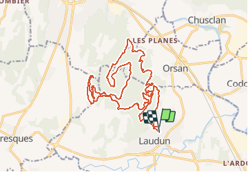
![](/images/other/stat-length.png)
![Excursión Ruta Laudun-l'Ardoise - Trail Le Gaulois - Photo](https://media.geolcdn.com/t/1900/400/ext.pjpeg?maxdim=2&url=https%3A%2F%2Fstatic1.geolcdn.com%2Fsiteimages%2Fupload%2Ffiles%2F1524743154running.jpg)
Trail Le Gaulois
florun30290
Usuario
![Longitud](/images/other/stat-length.png)
![Altitud máxima](https://static1.geolcdn.com/siteimages/upload/files/1508320355ic_sort_altitude_max_24dp.png)
![Desnivel positivo](https://static1.geolcdn.com/siteimages/upload/files/1508320355ic_sort_den_pos_24dp.png)
![Km-Effort](/images/other/stat-length.png)
![Altitud mínima](https://static1.geolcdn.com/siteimages/upload/files/1508320355ic_sort_altitude_min_24dp.png)
![Desnivel negativo](https://static1.geolcdn.com/siteimages/upload/files/1508320355ic_sort_den_neg_24dp.png)
![Boucle](https://static1.geolcdn.com/siteimages/upload/files/16400158638029165_repeat_loop_refresh_sync_direction_icon.png)
![Ruta](https://static1.geolcdn.com/sitytour/trail-icons/104.png)
--
Dificultad : Difícil
![Escanee este código QR para abrir la excursión en la aplicación SityTrail](https://capi.geolives.com/qq0zvz2zws4bq2lad0pu/sitytour/trails/2620013/qr.png?size=200)
Aplicación GPS de excursión GRATIS
A propósito
Ruta Ruta de 24 km a descubrir en Occitania, Gard, Laudun-l'Ardoise. Esta ruta ha sido propuesta por florun30290.
Descripción
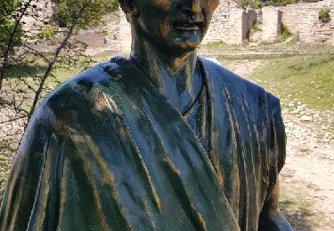
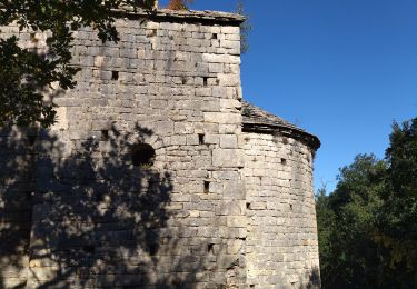
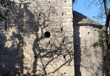
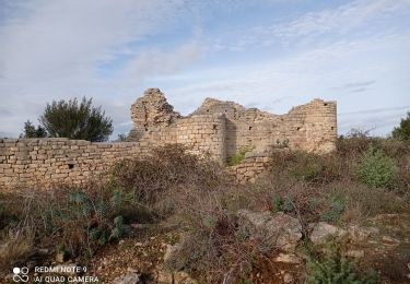
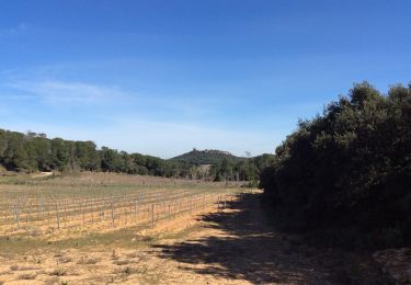
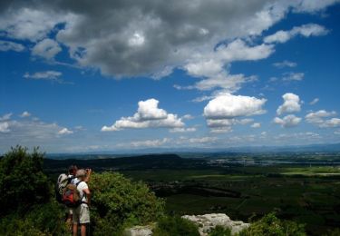
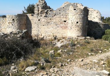
Le trail "Le Gaulois" (25kms, 970D ) ,inscrit au challenge gardois des trails, vous fera découvrir les plus beaux sites du Camp de César avec de magnifiques paysages notamment une vue somptueuse sur le Mont Ventoux.
Avant d'atteindre les vestiges gallo-romains vous monterez et descendrez des monotraces virevoltants traversant des forêts de chênes et autres végétations méditerranéennes. Des passages techniques et autres curiosités locales (Combe d'enfer Chapelle St Pierre, escaliers naturels...) viendront pimenter votre course !! Le parcours serpentera entre les vestiges archéologiques du Camp de César pour déboucher sur le fameux "passage du Loup" (27cm de large). Le final vous dirigera sous le pont de Balouvière, le "pont du Gard Laudunois", pour terminer au gymnase Léo Lagrange.
Localización
Comentarios
Excursiones cerca
![Excursión Senderismo Laudun-l'Ardoise - 30 camp de cesar - Photo](https://media.geolcdn.com/t/375/260/3a336c68-96d1-47ed-8893-44d2a09973df.jpg&format=jpg&maxdim=2)
![Senderismo Senderismo](https://static1.geolcdn.com/sitytour/trail-icons/101.png)
Senderismo
![](/images/other/stat-length.png)
![](https://static1.geolcdn.com/siteimages/upload/files/16400158638029165_repeat_loop_refresh_sync_direction_icon.png)
![Excursión Senderismo Laudun-l'Ardoise - Camp de César - Photo](https://media.geolcdn.com/t/375/260/d5a384ff-a456-4015-9a11-54cd89317120.jpg&format=jpg&maxdim=2)
![Senderismo Senderismo](https://static1.geolcdn.com/sitytour/trail-icons/101.png)
Senderismo
![](/images/other/stat-length.png)
![](https://static1.geolcdn.com/siteimages/upload/files/16400158638029165_repeat_loop_refresh_sync_direction_icon.png)
![Excursión Senderismo Laudun-l'Ardoise - 30 camp de César 12/07/23 - Photo](https://media.geolcdn.com/t/375/260/b6923c2c-a6f4-44eb-961e-2efc9564941a.jpg&format=jpg&maxdim=2)
![Senderismo Senderismo](https://static1.geolcdn.com/sitytour/trail-icons/101.png)
Senderismo
![](/images/other/stat-length.png)
![](https://static1.geolcdn.com/siteimages/upload/files/16400158638029165_repeat_loop_refresh_sync_direction_icon.png)
![Excursión Senderismo Chusclan - PF-Chusclan - Dent de Marcoule et Château de Gicon - Photo](https://media.geolcdn.com/t/375/260/f10873c5-07cb-49fe-9595-b037cf2e17a6.jpg&format=jpg&maxdim=2)
![Senderismo Senderismo](https://static1.geolcdn.com/sitytour/trail-icons/101.png)
Senderismo
![](/images/other/stat-length.png)
![](https://static1.geolcdn.com/siteimages/upload/files/16400158638029165_repeat_loop_refresh_sync_direction_icon.png)
![Excursión Senderismo Orsan - Chapelle St Pierre - Photo](https://media.geolcdn.com/t/375/260/ext.jpg?maxdim=2&url=https%3A%2F%2Fstatic1.geolcdn.com%2Fsiteimages%2Fupload%2Ffiles%2F1553511878bg_sport_marche.png)
![Senderismo Senderismo](https://static1.geolcdn.com/sitytour/trail-icons/101.png)
Senderismo
![](/images/other/stat-length.png)
![](https://static1.geolcdn.com/siteimages/upload/files/16400158638029165_repeat_loop_refresh_sync_direction_icon.png)
![Excursión Senderismo Orsan - Orsan - Chapelle de St Jean de Castres - Photo](https://media.geolcdn.com/t/375/260/ext.jpg?maxdim=2&url=https%3A%2F%2Fservices.sitytrail.com%2FGeolivesWS%2FDownloadMedia.ashx%3FTrailID%3D105314%26Media%3D9005_4.jpg)
![Senderismo Senderismo](https://static1.geolcdn.com/sitytour/trail-icons/101.png)
Senderismo
![](/images/other/stat-length.png)
![](https://static1.geolcdn.com/siteimages/upload/files/16400158638029165_repeat_loop_refresh_sync_direction_icon.png)
![Excursión Senderismo Orsan - Orsan - Photo](https://media.geolcdn.com/t/375/260/4eb1248d-2eba-4484-ab8d-a608b5d56ba5.jpg&format=jpg&maxdim=2)
![Senderismo Senderismo](https://static1.geolcdn.com/sitytour/trail-icons/101.png)
![Excursión Senderismo Laudun-l'Ardoise - Camp César 1 - Photo](https://media.geolcdn.com/t/375/260/c5bd3f62-f30a-42fe-a946-ba9608c8e44c.jpg&format=jpg&maxdim=2)
![Senderismo Senderismo](https://static1.geolcdn.com/sitytour/trail-icons/101.png)
Senderismo
![](/images/other/stat-length.png)
![](https://static1.geolcdn.com/siteimages/upload/files/16400158638029165_repeat_loop_refresh_sync_direction_icon.png)
![Excursión Senderismo Orsan - Camp de César - Photo](https://media.geolcdn.com/t/375/260/ext.jpg?maxdim=2&url=https%3A%2F%2Fservices.sitytrail.com%2FGeolivesWS%2FDownloadMedia.ashx%3FTrailID%3D951262%26Media%3Dfix__20180425145646.jpg)
![Senderismo Senderismo](https://static1.geolcdn.com/sitytour/trail-icons/101.png)