![](/images/other/stat-length.png)
![Excursión Senderismo Bailly-en-Rivière - Bailly huppy montigny - Photo](https://media.geolcdn.com/t/1900/400/ext.pjpeg?maxdim=2&url=https%3A%2F%2Fmedia.geolcdn.com%2Ff%2Fcad2e4d9-16bf-4670-ad2c-ca930a48c69b.jpg)
Bailly huppy montigny
Papy Diouf
Usuario
![Longitud](/images/other/stat-length.png)
Longitud
11 km
![Altitud máxima](https://static1.geolcdn.com/siteimages/upload/files/1508320355ic_sort_altitude_max_24dp.png)
Altitud máxima
178 m
![Desnivel positivo](https://static1.geolcdn.com/siteimages/upload/files/1508320355ic_sort_den_pos_24dp.png)
Desnivel positivo
221 m
![Km-Effort](/images/other/stat-length.png)
Km-Effort
13,9 km
![Altitud mínima](https://static1.geolcdn.com/siteimages/upload/files/1508320355ic_sort_altitude_min_24dp.png)
Altitud mínima
74 m
![Desnivel negativo](https://static1.geolcdn.com/siteimages/upload/files/1508320355ic_sort_den_neg_24dp.png)
Desnivel negativo
221 m
![Boucle](https://static1.geolcdn.com/siteimages/upload/files/16400158638029165_repeat_loop_refresh_sync_direction_icon.png)
Boucle
Sí
Fecha de creación :
2020-12-12 08:57:19.4
Última modificación :
2020-12-12 11:53:15.349
![Senderismo](https://static1.geolcdn.com/sitytour/trail-icons/101.png)
2h26
Dificultad : Muy fácil
![Escanee este código QR para abrir la excursión en la aplicación SityTrail](https://capi.geolives.com/qq0zvz2zws4bq2lad0pu/sitytour/trails/2617413/qr.png?size=200)
Aplicación GPS de excursión GRATIS
A propósito
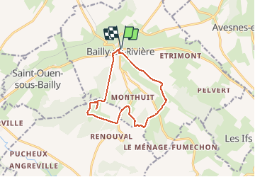
Ruta Senderismo de 11 km a descubrir en Normandía, Sena-Marítimo, Bailly-en-Rivière. Esta ruta ha sido propuesta por Papy Diouf.
Descripción
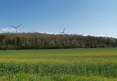
Circuit coupé par un cultivateur dans le bois de Farival par barbelés et clôture électrique sur le hameau de huppy alors que le chemin est balisé rando. Scandaleux
Localización
País:
France
Región :
Normandía
Departamento/provincia :
Sena-Marítimo
Municipio :
Bailly-en-Rivière
Localidad:
Unknown
Salida:(Dec)
Salida:(UTM)
380701 ; 5530300 (31U) N.
Comentarios
Excursiones cerca
![Excursión Senderismo Petit-Caux - DRC CHEMIN VERT DU PETIT-CAUX - Photo](https://media.geolcdn.com/t/375/260/ext.jpg?maxdim=2&url=https%3A%2F%2Fstatic1.geolcdn.com%2Fsiteimages%2Fupload%2Ffiles%2F1553511878bg_sport_marche.png)
![Senderismo Senderismo](https://static1.geolcdn.com/sitytour/trail-icons/101.png)
DRC CHEMIN VERT DU PETIT-CAUX
Senderismo
Fácil
Petit-Caux,
Normandía,
Sena-Marítimo,
France
![](/images/other/stat-length.png)
16,7 km | 18,9 km-effort
4h 17min
![](https://static1.geolcdn.com/siteimages/upload/files/16400158638029165_repeat_loop_refresh_sync_direction_icon.png)
No
![Excursión A pie Petit-Caux - Chemin Vert du Petit Caux - Photo](https://media.geolcdn.com/t/375/260/ext.jpg?maxdim=2&url=https%3A%2F%2Fstatic1.geolcdn.com%2Fsiteimages%2Fupload%2Ffiles%2F1545311037marcheuse_200dpi.jpg)
![A pie A pie](https://static1.geolcdn.com/sitytour/trail-icons/100.png)
Chemin Vert du Petit Caux
A pie
Fácil
Petit-Caux,
Normandía,
Sena-Marítimo,
France
![](/images/other/stat-length.png)
16,6 km | 18,8 km-effort
4h 16min
![](https://static1.geolcdn.com/siteimages/upload/files/16400158638029165_repeat_loop_refresh_sync_direction_icon.png)
No
![Excursión A pie Saint-Martin-le-Gaillard - Gratte-Panche - Photo](https://media.geolcdn.com/t/375/260/ext.jpg?maxdim=2&url=https%3A%2F%2Fstatic1.geolcdn.com%2Fsiteimages%2Fupload%2Ffiles%2F1545311037marcheuse_200dpi.jpg)
![A pie A pie](https://static1.geolcdn.com/sitytour/trail-icons/100.png)
Gratte-Panche
A pie
Medio
Saint-Martin-le-Gaillard,
Normandía,
Sena-Marítimo,
France
![](/images/other/stat-length.png)
16 km | 20 km-effort
4h 33min
![](https://static1.geolcdn.com/siteimages/upload/files/16400158638029165_repeat_loop_refresh_sync_direction_icon.png)
Sí
![Excursión Senderismo Petit-Caux - greny petit caux - Photo](https://media.geolcdn.com/t/375/260/ext.jpg?maxdim=2&url=https%3A%2F%2Fmedia.geolcdn.com%2Ff%2F46a6631d-07a1-4e84-b52e-ffa471157c7c.jpg)
![Senderismo Senderismo](https://static1.geolcdn.com/sitytour/trail-icons/101.png)
greny petit caux
Senderismo
Difícil
Petit-Caux,
Normandía,
Sena-Marítimo,
France
![](/images/other/stat-length.png)
10,7 km | 12,3 km-effort
1h 49min
![](https://static1.geolcdn.com/siteimages/upload/files/16400158638029165_repeat_loop_refresh_sync_direction_icon.png)
Sí
![Excursión Senderismo Saint-Ouen-sous-Bailly - Saint Ouen sous Bailly - Photo](https://media.geolcdn.com/t/375/260/ext.jpg?maxdim=2&url=https%3A%2F%2Fstatic1.geolcdn.com%2Fsiteimages%2Fupload%2Ffiles%2F1553511878bg_sport_marche.png)
![Senderismo Senderismo](https://static1.geolcdn.com/sitytour/trail-icons/101.png)
Saint Ouen sous Bailly
Senderismo
Fácil
Saint-Ouen-sous-Bailly,
Normandía,
Sena-Marítimo,
France
![](/images/other/stat-length.png)
5,2 km | 6,1 km-effort
1h 19min
![](https://static1.geolcdn.com/siteimages/upload/files/16400158638029165_repeat_loop_refresh_sync_direction_icon.png)
No
![Excursión Senderismo Envermeu - ENVERMEU (St Ouen S/BAILLY) - Photo](https://media.geolcdn.com/t/375/260/ext.jpg?maxdim=2&url=https%3A%2F%2Fstatic1.geolcdn.com%2Fsiteimages%2Fupload%2Ffiles%2F1553511878bg_sport_marche.png)
![Senderismo Senderismo](https://static1.geolcdn.com/sitytour/trail-icons/101.png)
ENVERMEU (St Ouen S/BAILLY)
Senderismo
Medio
(1)
Envermeu,
Normandía,
Sena-Marítimo,
France
![](/images/other/stat-length.png)
9,2 km | 11,2 km-effort
2h 33min
![](https://static1.geolcdn.com/siteimages/upload/files/16400158638029165_repeat_loop_refresh_sync_direction_icon.png)
Sí
![Excursión Senderismo Envermeu - ENVERMEU (st Ouen ) - Photo](https://media.geolcdn.com/t/375/260/ext.jpg?maxdim=2&url=https%3A%2F%2Fstatic1.geolcdn.com%2Fsiteimages%2Fupload%2Ffiles%2F1553511878bg_sport_marche.png)
![Senderismo Senderismo](https://static1.geolcdn.com/sitytour/trail-icons/101.png)
ENVERMEU (st Ouen )
Senderismo
Difícil
Envermeu,
Normandía,
Sena-Marítimo,
France
![](/images/other/stat-length.png)
10,9 km | 12,7 km-effort
2h 53min
![](https://static1.geolcdn.com/siteimages/upload/files/16400158638029165_repeat_loop_refresh_sync_direction_icon.png)
Sí