![](/images/other/stat-length.png)
![Excursión Ruta Réauville - GR429 de Ayguebelle à Viviers - Photo](https://media.geolcdn.com/t/1900/400/ext.pjpeg?maxdim=2&url=https%3A%2F%2Fstatic1.geolcdn.com%2Fsiteimages%2Fupload%2Ffiles%2F1524743154running.jpg)
GR429 de Ayguebelle à Viviers
lulubarteam
Usuario
![Longitud](/images/other/stat-length.png)
Longitud
23 km
![Altitud máxima](https://static1.geolcdn.com/siteimages/upload/files/1508320355ic_sort_altitude_max_24dp.png)
Altitud máxima
380 m
![Desnivel positivo](https://static1.geolcdn.com/siteimages/upload/files/1508320355ic_sort_den_pos_24dp.png)
Desnivel positivo
514 m
![Km-Effort](/images/other/stat-length.png)
Km-Effort
31 km
![Altitud mínima](https://static1.geolcdn.com/siteimages/upload/files/1508320355ic_sort_altitude_min_24dp.png)
Altitud mínima
61 m
![Desnivel negativo](https://static1.geolcdn.com/siteimages/upload/files/1508320355ic_sort_den_neg_24dp.png)
Desnivel negativo
638 m
![Boucle](https://static1.geolcdn.com/siteimages/upload/files/16400158638029165_repeat_loop_refresh_sync_direction_icon.png)
Boucle
No
Fecha de creación :
2020-12-05 08:03:05.585
Última modificación :
2020-12-05 08:08:38.375
![Ruta](https://static1.geolcdn.com/sitytour/trail-icons/104.png)
3h00
Dificultad : Muy fácil
![Escanee este código QR para abrir la excursión en la aplicación SityTrail](https://capi.geolives.com/qq0zvz2zws4bq2lad0pu/sitytour/trails/2613130/qr.png?size=200)
Aplicación GPS de excursión GRATIS
A propósito
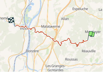
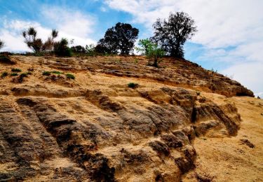
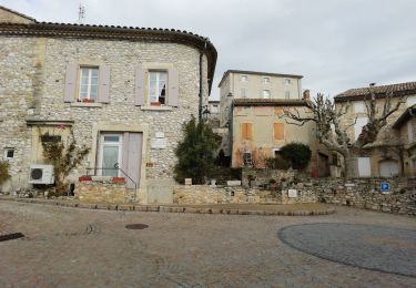
Ruta Ruta de 23 km a descubrir en Auvergne-Rhône-Alpes, Drôme, Réauville. Esta ruta ha sido propuesta por lulubarteam.
Descripción
Cet itinéraire assure la liaison entre le GR® 9 et le GR® 42. La partie complète allant de Dieulefit à Viviers.
Localización
País:
France
Región :
Auvergne-Rhône-Alpes
Departamento/provincia :
Drôme
Municipio :
Réauville
Localidad:
Unknown
Salida:(Dec)
Salida:(UTM)
646427 ; 4924862 (31T) N.
Comentarios
Excursiones cerca
![Excursión Senderismo Roussas - Roussas le Vernet 10km. - Photo](https://media.geolcdn.com/t/375/260/69de5ff3-2ab5-4bbd-b379-bc7253ad9aad.jpg&format=jpg&maxdim=2)
![Senderismo Senderismo](https://static1.geolcdn.com/sitytour/trail-icons/101.png)
Roussas le Vernet 10km.
Senderismo
Difícil
(1)
Roussas,
Auvergne-Rhône-Alpes,
Drôme,
France
![](/images/other/stat-length.png)
10,3 km | 14,1 km-effort
3h 12min
![](https://static1.geolcdn.com/siteimages/upload/files/16400158638029165_repeat_loop_refresh_sync_direction_icon.png)
Sí
![Excursión Senderismo Réauville - Reauville Aiguebelle Cascacades 10km - Photo](https://media.geolcdn.com/t/375/260/c8066850-a8b6-4767-b8cc-00eee53525df.jpg&format=jpg&maxdim=2)
![Senderismo Senderismo](https://static1.geolcdn.com/sitytour/trail-icons/101.png)
Reauville Aiguebelle Cascacades 10km
Senderismo
Medio
(1)
Réauville,
Auvergne-Rhône-Alpes,
Drôme,
France
![](/images/other/stat-length.png)
9,3 km | 11,6 km-effort
3h 0min
![](https://static1.geolcdn.com/siteimages/upload/files/16400158638029165_repeat_loop_refresh_sync_direction_icon.png)
Sí
![Excursión Senderismo Roussas - Roussas Panassas 8 km - Photo](https://media.geolcdn.com/t/375/260/daa93b3b-e486-4ddd-9c21-8f099d0a496e.jpg&format=jpg&maxdim=2)
![Senderismo Senderismo](https://static1.geolcdn.com/sitytour/trail-icons/101.png)
Roussas Panassas 8 km
Senderismo
Fácil
(1)
Roussas,
Auvergne-Rhône-Alpes,
Drôme,
France
![](/images/other/stat-length.png)
7,8 km | 10,6 km-effort
2h 31min
![](https://static1.geolcdn.com/siteimages/upload/files/16400158638029165_repeat_loop_refresh_sync_direction_icon.png)
Sí
![Excursión Senderismo Allan - allan transclavienne rac - Photo](https://media.geolcdn.com/t/375/260/ext.jpg?maxdim=2&url=https%3A%2F%2Fservices.sitytrail.com%2FGeolivesWS%2FDownloadMedia.ashx%3FTrailID%3D649381%26Media%3Dfix__20161022171755.jpg)
![Senderismo Senderismo](https://static1.geolcdn.com/sitytour/trail-icons/101.png)
allan transclavienne rac
Senderismo
Muy fácil
(1)
Allan,
Auvergne-Rhône-Alpes,
Drôme,
France
![](/images/other/stat-length.png)
19,1 km | 26 km-effort
5h 11min
![](https://static1.geolcdn.com/siteimages/upload/files/16400158638029165_repeat_loop_refresh_sync_direction_icon.png)
Sí
![Senderismo Senderismo](https://static1.geolcdn.com/sitytour/trail-icons/101.png)
2022-10-10_11h21m09_tmpWriteApidae_259847_fr
Senderismo
Medio
Allan,
Auvergne-Rhône-Alpes,
Drôme,
France
![](/images/other/stat-length.png)
10,7 km | 15,2 km-effort
3h 27min
![](https://static1.geolcdn.com/siteimages/upload/files/16400158638029165_repeat_loop_refresh_sync_direction_icon.png)
Sí
![Excursión Senderismo La Touche - Citelles hameau et ruisseaux 10km - Photo](https://media.geolcdn.com/t/375/260/ae07cd43-efe5-443c-ada6-328c965bd163.jpg&format=jpg&maxdim=2)
![Senderismo Senderismo](https://static1.geolcdn.com/sitytour/trail-icons/101.png)
Citelles hameau et ruisseaux 10km
Senderismo
Fácil
(2)
La Touche,
Auvergne-Rhône-Alpes,
Drôme,
France
![](/images/other/stat-length.png)
9,6 km | 12,6 km-effort
3h 7min
![](https://static1.geolcdn.com/siteimages/upload/files/16400158638029165_repeat_loop_refresh_sync_direction_icon.png)
Sí
![Excursión Senderismo Réauville - 2020-02-11_18h44m28_Réauville 7km - Photo](https://media.geolcdn.com/t/375/260/f1284678-f60d-4523-b920-9ecd6b4d9650.jpg&format=jpg&maxdim=2)
![Senderismo Senderismo](https://static1.geolcdn.com/sitytour/trail-icons/101.png)
2020-02-11_18h44m28_Réauville 7km
Senderismo
Medio
Réauville,
Auvergne-Rhône-Alpes,
Drôme,
France
![](/images/other/stat-length.png)
6,9 km | 8,2 km-effort
1h 51min
![](https://static1.geolcdn.com/siteimages/upload/files/16400158638029165_repeat_loop_refresh_sync_direction_icon.png)
Sí
![Excursión Senderismo Valaurie - Valaurie Aiguebelle 16km - Photo](https://media.geolcdn.com/t/375/260/dd559e93-ad87-4ef8-876d-977a34ec8b7a.jpg&format=jpg&maxdim=2)
![Senderismo Senderismo](https://static1.geolcdn.com/sitytour/trail-icons/101.png)
Valaurie Aiguebelle 16km
Senderismo
Medio
Valaurie,
Auvergne-Rhône-Alpes,
Drôme,
France
![](/images/other/stat-length.png)
16 km | 21 km-effort
5h 0min
![](https://static1.geolcdn.com/siteimages/upload/files/16400158638029165_repeat_loop_refresh_sync_direction_icon.png)
Sí
![Excursión sport Allan - SityTrail - Les Villages Perchés. - Photo](https://media.geolcdn.com/t/375/260/ext.jpg?maxdim=2&url=https%3A%2F%2Fsecurestorage.geolives.com%2Fsitytour%2Ftrail-bg%2Fdefault.jpg)
SityTrail - Les Villages Perchés.
sport
Muy fácil
(1)
Allan,
Auvergne-Rhône-Alpes,
Drôme,
France
![](/images/other/stat-length.png)
19,5 km | 27 km-effort
Desconocido
![](https://static1.geolcdn.com/siteimages/upload/files/16400158638029165_repeat_loop_refresh_sync_direction_icon.png)
Sí