![](/images/other/stat-length.png)
![Excursión Senderismo Le Tampon - La Réunion - Boucle du parcours sportif de Bel Air, par la ravine de la rivière d'abord. - Photo](https://media.geolcdn.com/t/1900/400/ext.pjpeg?maxdim=2&url=https%3A%2F%2Fservices.sitytrail.com%2FGeolivesWS%2FDownloadMedia.ashx%3FTrailID%3D258585%26Media%3Dfix__20140319154522.jpg)
La Réunion - Boucle du parcours sportif de Bel Air, par la ravine de la rivière d'abord.
olive2b
Usuario
![Longitud](/images/other/stat-length.png)
Longitud
4 km
![Altitud máxima](https://static1.geolcdn.com/siteimages/upload/files/1508320355ic_sort_altitude_max_24dp.png)
Altitud máxima
500 m
![Desnivel positivo](https://static1.geolcdn.com/siteimages/upload/files/1508320355ic_sort_den_pos_24dp.png)
Desnivel positivo
116 m
![Km-Effort](/images/other/stat-length.png)
Km-Effort
5,5 km
![Altitud mínima](https://static1.geolcdn.com/siteimages/upload/files/1508320355ic_sort_altitude_min_24dp.png)
Altitud mínima
406 m
![Desnivel negativo](https://static1.geolcdn.com/siteimages/upload/files/1508320355ic_sort_den_neg_24dp.png)
Desnivel negativo
109 m
![Boucle](https://static1.geolcdn.com/siteimages/upload/files/16400158638029165_repeat_loop_refresh_sync_direction_icon.png)
Boucle
Sí
Fecha de creación :
2016-03-09 00:00:00.0
Última modificación :
2016-03-09 00:00:00.0
![Senderismo](https://static1.geolcdn.com/sitytour/trail-icons/101.png)
1h22
Dificultad : Fácil
![Escanee este código QR para abrir la excursión en la aplicación SityTrail](https://capi.geolives.com/qq0zvz2zws4bq2lad0pu/sitytour/trails/258585/qr.png?size=200)
Aplicación GPS de excursión GRATIS
A propósito
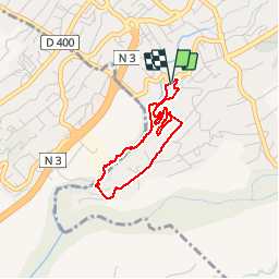
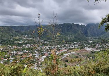
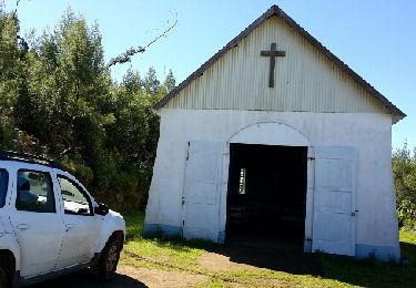
Ruta Senderismo de 4 km a descubrir en La Reunión, Desconocido, Le Tampon. Esta ruta ha sido propuesta por olive2b.
Descripción
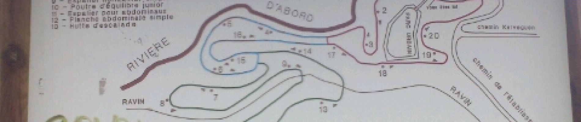
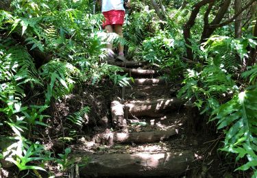
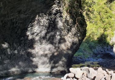
Balade agréable sur la première partie du chemin quand on descend dans la ravine de la rivière d'abord. La seconde partie est juste une liaison jusqu'à la troisième partie qui est le parcours sportif.
Localización
País:
France
Región :
La Reunión
Departamento/provincia :
Desconocido
Municipio :
Le Tampon
Localidad:
Unknown
Salida:(Dec)
Salida:(UTM)
346330 ; 7645037 (40K) S.
Comentarios
Excursiones cerca
![Excursión Senderismo Saint-Pierre - Piton Mont Vert 20190217 SH - Photo](https://media.geolcdn.com/t/375/260/6915dbe3-caff-46a5-a466-fa66dec5f931.jpg&format=jpg&maxdim=2)
![Senderismo Senderismo](https://static1.geolcdn.com/sitytour/trail-icons/101.png)
Piton Mont Vert 20190217 SH
Senderismo
Medio
(1)
Saint-Pierre,
La Reunión,
Desconocido,
France
![](/images/other/stat-length.png)
2,3 km | 3,7 km-effort
1h 42min
![](https://static1.geolcdn.com/siteimages/upload/files/16400158638029165_repeat_loop_refresh_sync_direction_icon.png)
Sí
![Excursión Senderismo Le Tampon - Sentier Dassy ( Tampon) - Photo](https://media.geolcdn.com/t/375/260/ext.jpg?maxdim=2&url=https%3A%2F%2Fstatic1.geolcdn.com%2Fsiteimages%2Fupload%2Ffiles%2F1553511878bg_sport_marche.png)
![Senderismo Senderismo](https://static1.geolcdn.com/sitytour/trail-icons/101.png)
Sentier Dassy ( Tampon)
Senderismo
Medio
(1)
Le Tampon,
La Reunión,
Desconocido,
France
![](/images/other/stat-length.png)
5,6 km | 12,3 km-effort
1h 25min
![](https://static1.geolcdn.com/siteimages/upload/files/16400158638029165_repeat_loop_refresh_sync_direction_icon.png)
Sí
![Excursión Senderismo Entre-Deux - Tour d'Entre Deux - Photo](https://media.geolcdn.com/t/375/260/ext.jpg?maxdim=2&url=https%3A%2F%2Fstatic1.geolcdn.com%2Fsiteimages%2Fupload%2Ffiles%2F1553511878bg_sport_marche.png)
![Senderismo Senderismo](https://static1.geolcdn.com/sitytour/trail-icons/101.png)
Tour d'Entre Deux
Senderismo
Medio
(1)
Entre-Deux,
La Reunión,
Desconocido,
France
![](/images/other/stat-length.png)
10,6 km | 17,9 km-effort
4h 0min
![](https://static1.geolcdn.com/siteimages/upload/files/16400158638029165_repeat_loop_refresh_sync_direction_icon.png)
Sí
![Excursión Senderismo Entre-Deux - Le tour de l'entre-deux - Photo](https://media.geolcdn.com/t/375/260/43411191-273a-4292-a289-21264fab8423.jpg&format=jpg&maxdim=2)
![Senderismo Senderismo](https://static1.geolcdn.com/sitytour/trail-icons/101.png)
Le tour de l'entre-deux
Senderismo
Medio
Entre-Deux,
La Reunión,
Desconocido,
France
![](/images/other/stat-length.png)
9,4 km | 15,3 km-effort
3h 8min
![](https://static1.geolcdn.com/siteimages/upload/files/16400158638029165_repeat_loop_refresh_sync_direction_icon.png)
Sí
![Senderismo Senderismo](https://static1.geolcdn.com/sitytour/trail-icons/101.png)
RandoPitons.re #1416 - De Saint-Louis à Bois Court par le Bras de la Plaine e...
Senderismo
Difícil
Le Tampon,
La Reunión,
Desconocido,
France
![](/images/other/stat-length.png)
8,7 km | 16,9 km-effort
3h 18min
![](https://static1.geolcdn.com/siteimages/upload/files/16400158638029165_repeat_loop_refresh_sync_direction_icon.png)
No
![Excursión Senderismo Entre-Deux - Dimitile en 4x4 et à pied - Photo](https://media.geolcdn.com/t/375/260/ext.jpg?maxdim=2&url=https%3A%2F%2Fservices.sitytrail.com%2FGeolivesWS%2FDownloadMedia.ashx%3FTrailID%3D452672%26Media%3Dfix__20150710123136.jpg)
![Senderismo Senderismo](https://static1.geolcdn.com/sitytour/trail-icons/101.png)
Dimitile en 4x4 et à pied
Senderismo
Medio
Entre-Deux,
La Reunión,
Desconocido,
France
![](/images/other/stat-length.png)
41 km | 69 km-effort
5h 47min
![](https://static1.geolcdn.com/siteimages/upload/files/16400158638029165_repeat_loop_refresh_sync_direction_icon.png)
No
![Excursión Senderismo Le Tampon - 2023 11-12-reconnaissance de la ravine cascade - Photo](https://media.geolcdn.com/t/375/260/ca3aad43-4450-4f7b-96ba-cf859159a906.jpg&format=jpg&maxdim=2)
![Senderismo Senderismo](https://static1.geolcdn.com/sitytour/trail-icons/101.png)
2023 11-12-reconnaissance de la ravine cascade
Senderismo
Fácil
Le Tampon,
La Reunión,
Desconocido,
France
![](/images/other/stat-length.png)
1,7 km | 2,6 km-effort
21min
![](https://static1.geolcdn.com/siteimages/upload/files/16400158638029165_repeat_loop_refresh_sync_direction_icon.png)
No
![Excursión Senderismo Entre-Deux - Fond de la Rivière - Photo](https://media.geolcdn.com/t/375/260/ext.jpg?maxdim=2&url=https%3A%2F%2Fstatic1.geolcdn.com%2Fsiteimages%2Fupload%2Ffiles%2F1553511878bg_sport_marche.png)
![Senderismo Senderismo](https://static1.geolcdn.com/sitytour/trail-icons/101.png)
Fond de la Rivière
Senderismo
Fácil
Entre-Deux,
La Reunión,
Desconocido,
France
![](/images/other/stat-length.png)
3,1 km | 6 km-effort
1h 22min
![](https://static1.geolcdn.com/siteimages/upload/files/16400158638029165_repeat_loop_refresh_sync_direction_icon.png)
Sí
![Excursión Senderismo Entre-Deux - Fond de la rivière - Photo](https://media.geolcdn.com/t/375/260/ext.jpg?maxdim=2&url=https%3A%2F%2Fstatic1.geolcdn.com%2Fsiteimages%2Fupload%2Ffiles%2F1553511878bg_sport_marche.png)
![Senderismo Senderismo](https://static1.geolcdn.com/sitytour/trail-icons/101.png)
Fond de la rivière
Senderismo
Difícil
Entre-Deux,
La Reunión,
Desconocido,
France
![](/images/other/stat-length.png)
4,4 km | 9,2 km-effort
1h 50min
![](https://static1.geolcdn.com/siteimages/upload/files/16400158638029165_repeat_loop_refresh_sync_direction_icon.png)
Sí