![](/images/other/stat-length.png)
![Excursión A pie Névache - Alpes jour 3: Vallée Etroite à - Photo](https://media.geolcdn.com/t/1900/400/ext.pjpeg?maxdim=2&url=https%3A%2F%2Fstatic1.geolcdn.com%2Fsiteimages%2Fupload%2Ffiles%2F1545311037marcheuse_200dpi.jpg)
Alpes jour 3: Vallée Etroite à
MathieuBourgois
Usuario
![Longitud](/images/other/stat-length.png)
Longitud
17,1 km
![Altitud máxima](https://static1.geolcdn.com/siteimages/upload/files/1508320355ic_sort_altitude_max_24dp.png)
Altitud máxima
2187 m
![Desnivel positivo](https://static1.geolcdn.com/siteimages/upload/files/1508320355ic_sort_den_pos_24dp.png)
Desnivel positivo
1044 m
![Km-Effort](/images/other/stat-length.png)
Km-Effort
30 km
![Altitud mínima](https://static1.geolcdn.com/siteimages/upload/files/1508320355ic_sort_altitude_min_24dp.png)
Altitud mínima
1480 m
![Desnivel negativo](https://static1.geolcdn.com/siteimages/upload/files/1508320355ic_sort_den_neg_24dp.png)
Desnivel negativo
625 m
![Boucle](https://static1.geolcdn.com/siteimages/upload/files/16400158638029165_repeat_loop_refresh_sync_direction_icon.png)
Boucle
No
Fecha de creación :
2020-10-16 08:11:23.093
Última modificación :
2021-06-01 12:13:05.896
![A pie](https://static1.geolcdn.com/sitytour/trail-icons/100.png)
--
Dificultad : Medio
![Escanee este código QR para abrir la excursión en la aplicación SityTrail](https://capi.geolives.com/qq0zvz2zws4bq2lad0pu/sitytour/trails/2578528/qr.png?size=200)
Aplicación GPS de excursión GRATIS
A propósito
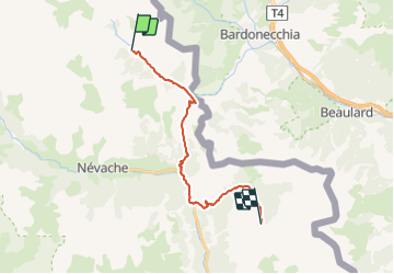
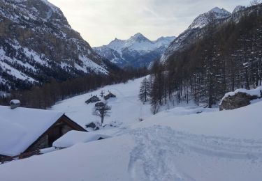
Ruta A pie de 17,1 km a descubrir en Provenza-Alpes-Costa Azul, Altos Alpes, Névache. Esta ruta ha sido propuesta por MathieuBourgois.
Descripción
Col des Thures 3.3km et 420D
Roubion 8.4km et 430D
Pamplinet 12km et 460D
Chalet des Acles 16km et 880D
Lieux de Bivouac 18km et 1200D
Localización
País:
France
Región :
Provenza-Alpes-Costa Azul
Departamento/provincia :
Altos Alpes
Municipio :
Névache
Localidad:
Unknown
Salida:(Dec)
Salida:(UTM)
312855 ; 4993563 (32T) N.
Comentarios
Excursiones cerca
![Excursión Senderismo Névache - Lac Vert.Vallée Etroite.(27-09-17) - Photo](https://media.geolcdn.com/t/375/260/ext.jpg?maxdim=2&url=https%3A%2F%2Fservices.sitytrail.com%2FGeolivesWS%2FDownloadMedia.ashx%3FTrailID%3D836355%26Media%3Dfix__20170927160031.jpg)
![Senderismo Senderismo](https://static1.geolcdn.com/sitytour/trail-icons/101.png)
Lac Vert.Vallée Etroite.(27-09-17)
Senderismo
Muy fácil
(1)
Névache,
Provenza-Alpes-Costa Azul,
Altos Alpes,
France
![](/images/other/stat-length.png)
4,2 km | 5,9 km-effort
1h 19min
![](https://static1.geolcdn.com/siteimages/upload/files/16400158638029165_repeat_loop_refresh_sync_direction_icon.png)
Sí
![Excursión Senderismo Névache - les granges de la vallée étroite au refuge du Mont Thabor - Photo](https://media.geolcdn.com/t/375/260/ext.jpg?maxdim=2&url=https%3A%2F%2Fservices.sitytrail.com%2FGeolivesWS%2FDownloadMedia.ashx%3FTrailID%3D654587%26Media%3Dfix__20161029145821.jpg)
![Senderismo Senderismo](https://static1.geolcdn.com/sitytour/trail-icons/101.png)
les granges de la vallée étroite au refuge du Mont Thabor
Senderismo
Fácil
(1)
Névache,
Provenza-Alpes-Costa Azul,
Altos Alpes,
France
![](/images/other/stat-length.png)
8,6 km | 16,2 km-effort
3h 44min
![](https://static1.geolcdn.com/siteimages/upload/files/16400158638029165_repeat_loop_refresh_sync_direction_icon.png)
No
![Excursión Bici de montaña Névache - Tour des Rois Mages en VTT - Névache - Photo](https://media.geolcdn.com/t/375/260/ext.jpg?maxdim=2&url=https%3A%2F%2Fservices.sitytrail.com%2FGeolivesWS%2FDownloadMedia.ashx%3FTrailID%3D105140%26Media%3D8755_6.jpg)
![Bici de montaña Bici de montaña](https://static1.geolcdn.com/sitytour/trail-icons/202.png)
Tour des Rois Mages en VTT - Névache
Bici de montaña
Difícil
(2)
Névache,
Provenza-Alpes-Costa Azul,
Altos Alpes,
France
![](/images/other/stat-length.png)
35 km | 55 km-effort
5h 0min
![](https://static1.geolcdn.com/siteimages/upload/files/16400158638029165_repeat_loop_refresh_sync_direction_icon.png)
Sí
![Excursión Senderismo Névache - le Mont Thabor - Photo](https://media.geolcdn.com/t/375/260/ext.jpg?maxdim=2&url=https%3A%2F%2Fservices.sitytrail.com%2FGeolivesWS%2FDownloadMedia.ashx%3FTrailID%3D1010217%26Media%3Dfix__20180724163126.jpg)
![Senderismo Senderismo](https://static1.geolcdn.com/sitytour/trail-icons/101.png)
le Mont Thabor
Senderismo
Difícil
Névache,
Provenza-Alpes-Costa Azul,
Altos Alpes,
France
![](/images/other/stat-length.png)
19,9 km | 40 km-effort
8h 44min
![](https://static1.geolcdn.com/siteimages/upload/files/16400158638029165_repeat_loop_refresh_sync_direction_icon.png)
Sí
![Excursión Senderismo Névache - Vallée étroite refuge du Thabor - Photo](https://media.geolcdn.com/t/375/260/ext.jpg?maxdim=2&url=https%3A%2F%2Fmedia.geolcdn.com%2Ff%2Fcaa80d0d-fb96-4075-98b9-465015f706c8.jpg)
![Senderismo Senderismo](https://static1.geolcdn.com/sitytour/trail-icons/101.png)
Vallée étroite refuge du Thabor
Senderismo
Difícil
Névache,
Provenza-Alpes-Costa Azul,
Altos Alpes,
France
![](/images/other/stat-length.png)
10,2 km | 18,4 km-effort
3h 6min
![](https://static1.geolcdn.com/siteimages/upload/files/16400158638029165_repeat_loop_refresh_sync_direction_icon.png)
No
![Excursión Senderismo Névache - J4 2023 - Le Thabor épisode 2 - Photo](https://media.geolcdn.com/t/375/260/ext.jpg?maxdim=2&url=https%3A%2F%2Fmedia.geolcdn.com%2Ff%2F6eb284de-df6c-41f9-bcd4-8d0010541a10.jpg)
![Senderismo Senderismo](https://static1.geolcdn.com/sitytour/trail-icons/101.png)
J4 2023 - Le Thabor épisode 2
Senderismo
Muy difícil
Névache,
Provenza-Alpes-Costa Azul,
Altos Alpes,
France
![](/images/other/stat-length.png)
24 km | 44 km-effort
7h 13min
![](https://static1.geolcdn.com/siteimages/upload/files/16400158638029165_repeat_loop_refresh_sync_direction_icon.png)
Sí
![Excursión Senderismo Névache - Mont Thabor à partir des Granges - Photo](https://media.geolcdn.com/t/375/260/ext.jpg?maxdim=2&url=https%3A%2F%2Fmedia.geolcdn.com%2Ff%2Fb11e8d82-1743-4a03-9b5b-b7f5a70282e9.jpg)
![Senderismo Senderismo](https://static1.geolcdn.com/sitytour/trail-icons/101.png)
Mont Thabor à partir des Granges
Senderismo
Muy difícil
Névache,
Provenza-Alpes-Costa Azul,
Altos Alpes,
France
![](/images/other/stat-length.png)
18,1 km | 37 km-effort
6h 39min
![](https://static1.geolcdn.com/siteimages/upload/files/16400158638029165_repeat_loop_refresh_sync_direction_icon.png)
No
![Excursión Esquí de fondo Névache - mont thabor - Photo](https://media.geolcdn.com/t/375/260/ext.jpg?maxdim=2&url=https%3A%2F%2Fmedia.geolcdn.com%2Ff%2F1fa36a59-1268-4337-a86b-af6077f119fc.jpg)
![Esquí de fondo Esquí de fondo](https://static1.geolcdn.com/sitytour/trail-icons/503.png)
mont thabor
Esquí de fondo
Difícil
Névache,
Provenza-Alpes-Costa Azul,
Altos Alpes,
France
![](/images/other/stat-length.png)
799 km | 2069 km-effort
6h 18min
![](https://static1.geolcdn.com/siteimages/upload/files/16400158638029165_repeat_loop_refresh_sync_direction_icon.png)
No
![Excursión Senderismo Névache - les ascles 05 - Photo](https://media.geolcdn.com/t/375/260/ext.jpg?maxdim=2&url=https%3A%2F%2Fservices.sitytrail.com%2FGeolivesWS%2FDownloadMedia.ashx%3FTrailID%3D850527%26Media%3D20170825143413.jpg)
![Senderismo Senderismo](https://static1.geolcdn.com/sitytour/trail-icons/101.png)
les ascles 05
Senderismo
Fácil
Névache,
Provenza-Alpes-Costa Azul,
Altos Alpes,
France
![](/images/other/stat-length.png)
12,8 km | 23 km-effort
6h 1min
![](https://static1.geolcdn.com/siteimages/upload/files/16400158638029165_repeat_loop_refresh_sync_direction_icon.png)
No