![](/images/other/stat-length.png)
![Excursión Senderismo Sotteville-sous-le-Val - Sotteville-sous-le-Val vers Freneuse 11 km - Photo](https://media.geolcdn.com/t/1900/400/bd013d32-5da9-4df6-b6d6-47e3b0b1fa30.jpg&format=pjpeg&maxdim=2)
Sotteville-sous-le-Val vers Freneuse 11 km
MichelRando7656
Usuario
![Longitud](/images/other/stat-length.png)
Longitud
11,1 km
![Altitud máxima](https://static1.geolcdn.com/siteimages/upload/files/1508320355ic_sort_altitude_max_24dp.png)
Altitud máxima
19 m
![Desnivel positivo](https://static1.geolcdn.com/siteimages/upload/files/1508320355ic_sort_den_pos_24dp.png)
Desnivel positivo
57 m
![Km-Effort](/images/other/stat-length.png)
Km-Effort
11,8 km
![Altitud mínima](https://static1.geolcdn.com/siteimages/upload/files/1508320355ic_sort_altitude_min_24dp.png)
Altitud mínima
1 m
![Desnivel negativo](https://static1.geolcdn.com/siteimages/upload/files/1508320355ic_sort_den_neg_24dp.png)
Desnivel negativo
59 m
![Boucle](https://static1.geolcdn.com/siteimages/upload/files/16400158638029165_repeat_loop_refresh_sync_direction_icon.png)
Boucle
Sí
Fecha de creación :
2020-10-15 11:40:50.111
Última modificación :
2020-10-15 14:51:26.139
![Senderismo](https://static1.geolcdn.com/sitytour/trail-icons/101.png)
3h09
Dificultad : Fácil
![Escanee este código QR para abrir la excursión en la aplicación SityTrail](https://capi.geolives.com/qq0zvz2zws4bq2lad0pu/sitytour/trails/2578174/qr.png?size=200)
Aplicación GPS de excursión GRATIS
A propósito
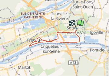
Ruta Senderismo de 11,1 km a descubrir en Normandía, Sena-Marítimo, Sotteville-sous-le-Val. Esta ruta ha sido propuesta por MichelRando7656.
Descripción
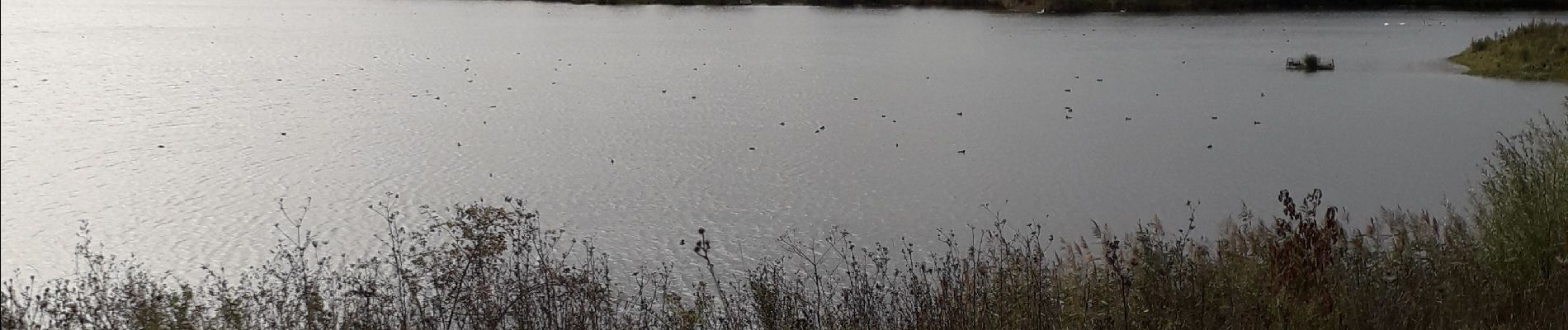
Promenade par les petits chemins, souvent herbeux, le longs des étangs. Pas de côtes significatives.
Localización
País:
France
Región :
Normandía
Departamento/provincia :
Sena-Marítimo
Municipio :
Sotteville-sous-le-Val
Localidad:
Unknown
Salida:(Dec)
Salida:(UTM)
363757 ; 5464706 (31U) N.
Comentarios
Excursiones cerca
![Excursión Senderismo Sotteville-sous-le-Val - Sotteville sous le Val vers Igoville - Photo](https://media.geolcdn.com/t/375/260/ext.jpg?maxdim=2&url=https%3A%2F%2Fservices.sitytrail.com%2FGeolivesWS%2FDownloadMedia.ashx%3FTrailID%3D954232%26Media%3Dfix__20180427145133.jpg)
![Senderismo Senderismo](https://static1.geolcdn.com/sitytour/trail-icons/101.png)
Sotteville sous le Val vers Igoville
Senderismo
Fácil
(1)
Sotteville-sous-le-Val,
Normandía,
Sena-Marítimo,
France
![](/images/other/stat-length.png)
8,7 km | 9,3 km-effort
1h 48min
![](https://static1.geolcdn.com/siteimages/upload/files/16400158638029165_repeat_loop_refresh_sync_direction_icon.png)
Sí
![Excursión Senderismo Oissel - 076-36-Oissel /les Essarts 13km-511-205 - Photo](https://media.geolcdn.com/t/375/260/ec83c66c-3a16-4133-93c3-fe87b7f1d0ed.jpg&format=jpg&maxdim=2)
![Senderismo Senderismo](https://static1.geolcdn.com/sitytour/trail-icons/101.png)
076-36-Oissel /les Essarts 13km-511-205
Senderismo
Medio
(1)
Oissel,
Normandía,
Sena-Marítimo,
France
![](/images/other/stat-length.png)
12,7 km | 15,2 km-effort
3h 19min
![](https://static1.geolcdn.com/siteimages/upload/files/16400158638029165_repeat_loop_refresh_sync_direction_icon.png)
No
![Excursión Senderismo Oissel - Oissel 13 km - Photo](https://media.geolcdn.com/t/375/260/ext.jpg?maxdim=2&url=https%3A%2F%2Fstatic1.geolcdn.com%2Fsiteimages%2Fupload%2Ffiles%2F1553511878bg_sport_marche.png)
![Senderismo Senderismo](https://static1.geolcdn.com/sitytour/trail-icons/101.png)
Oissel 13 km
Senderismo
Muy fácil
(1)
Oissel,
Normandía,
Sena-Marítimo,
France
![](/images/other/stat-length.png)
13,3 km | 15,2 km-effort
2h 35min
![](https://static1.geolcdn.com/siteimages/upload/files/16400158638029165_repeat_loop_refresh_sync_direction_icon.png)
Sí
![Excursión Senderismo Oissel - Oissel 13 km - Photo](https://media.geolcdn.com/t/375/260/ext.jpg?maxdim=2&url=https%3A%2F%2Fstatic1.geolcdn.com%2Fsiteimages%2Fupload%2Ffiles%2F1553511878bg_sport_marche.png)
![Senderismo Senderismo](https://static1.geolcdn.com/sitytour/trail-icons/101.png)
Oissel 13 km
Senderismo
Muy fácil
(1)
Oissel,
Normandía,
Sena-Marítimo,
France
![](/images/other/stat-length.png)
14,9 km | 16,9 km-effort
2h 35min
![](https://static1.geolcdn.com/siteimages/upload/files/16400158638029165_repeat_loop_refresh_sync_direction_icon.png)
Sí
![Excursión Ruta Les Damps - 20190820_135035 - Photo](https://media.geolcdn.com/t/375/260/ext.jpg?maxdim=2&url=https%3A%2F%2Fstatic1.geolcdn.com%2Fsiteimages%2Fupload%2Ffiles%2F1524743154running.jpg)
![Ruta Ruta](https://static1.geolcdn.com/sitytour/trail-icons/104.png)
20190820_135035
Ruta
Muy fácil
(1)
Les Damps,
Normandía,
Eure,
France
![](/images/other/stat-length.png)
10,9 km | 12,5 km-effort
Desconocido
![](https://static1.geolcdn.com/siteimages/upload/files/16400158638029165_repeat_loop_refresh_sync_direction_icon.png)
Sí
![Excursión Senderismo Oissel - Oissel 13 km - Photo](https://media.geolcdn.com/t/375/260/ext.jpg?maxdim=2&url=https%3A%2F%2Fstatic1.geolcdn.com%2Fsiteimages%2Fupload%2Ffiles%2F1553511878bg_sport_marche.png)
![Senderismo Senderismo](https://static1.geolcdn.com/sitytour/trail-icons/101.png)
Oissel 13 km
Senderismo
Muy fácil
(1)
Oissel,
Normandía,
Sena-Marítimo,
France
![](/images/other/stat-length.png)
13,6 km | 15,4 km-effort
2h 35min
![](https://static1.geolcdn.com/siteimages/upload/files/16400158638029165_repeat_loop_refresh_sync_direction_icon.png)
Sí
![Excursión Senderismo Pont-de-l'Arche - Pont de l'Arche/ Les Damps (126) - Photo](https://media.geolcdn.com/t/375/260/ext.jpg?maxdim=2&url=https%3A%2F%2Fstatic1.geolcdn.com%2Fsiteimages%2Fupload%2Ffiles%2F1553511878bg_sport_marche.png)
![Senderismo Senderismo](https://static1.geolcdn.com/sitytour/trail-icons/101.png)
Pont de l'Arche/ Les Damps (126)
Senderismo
Medio
(4)
Pont-de-l'Arche,
Normandía,
Eure,
France
![](/images/other/stat-length.png)
11,5 km | 13,9 km-effort
3h 3min
![](https://static1.geolcdn.com/siteimages/upload/files/16400158638029165_repeat_loop_refresh_sync_direction_icon.png)
Sí
![Excursión Senderismo Ymare - Ymare - Photo](https://media.geolcdn.com/t/375/260/ext.jpg?maxdim=2&url=https%3A%2F%2Fstatic1.geolcdn.com%2Fsiteimages%2Fupload%2Ffiles%2F1553511878bg_sport_marche.png)
![Senderismo Senderismo](https://static1.geolcdn.com/sitytour/trail-icons/101.png)
Ymare
Senderismo
Muy fácil
(1)
Ymare,
Normandía,
Sena-Marítimo,
France
![](/images/other/stat-length.png)
8,9 km | 10,6 km-effort
2h 0min
![](https://static1.geolcdn.com/siteimages/upload/files/16400158638029165_repeat_loop_refresh_sync_direction_icon.png)
Sí
![Excursión Senderismo Les Authieux-sur-le-Port-Saint-Ouen - *les Authieux Igoville 15km - Photo](https://media.geolcdn.com/t/375/260/acace470-e678-4207-9fe1-f083d26db0f1.jpg&format=jpg&maxdim=2)
![Senderismo Senderismo](https://static1.geolcdn.com/sitytour/trail-icons/101.png)
*les Authieux Igoville 15km
Senderismo
Muy fácil
(1)
Les Authieux-sur-le-Port-Saint-Ouen,
Normandía,
Sena-Marítimo,
France
![](/images/other/stat-length.png)
13,9 km | 16,5 km-effort
3h 37min
![](https://static1.geolcdn.com/siteimages/upload/files/16400158638029165_repeat_loop_refresh_sync_direction_icon.png)
Sí