![](/images/other/stat-length.png)
![Excursión Senderismo Hèches - G3 Les Landes de Rebouc 2020-10-12 - Photo](https://media.geolcdn.com/t/1900/400/ext.pjpeg?maxdim=2&url=https%3A%2F%2Fstatic1.geolcdn.com%2Fsiteimages%2Fupload%2Ffiles%2F1553511878bg_sport_marche.png)
G3 Les Landes de Rebouc 2020-10-12
mitch1952
Usuario
![Longitud](/images/other/stat-length.png)
Longitud
8,5 km
![Altitud máxima](https://static1.geolcdn.com/siteimages/upload/files/1508320355ic_sort_altitude_max_24dp.png)
Altitud máxima
980 m
![Desnivel positivo](https://static1.geolcdn.com/siteimages/upload/files/1508320355ic_sort_den_pos_24dp.png)
Desnivel positivo
418 m
![Km-Effort](/images/other/stat-length.png)
Km-Effort
14,1 km
![Altitud mínima](https://static1.geolcdn.com/siteimages/upload/files/1508320355ic_sort_altitude_min_24dp.png)
Altitud mínima
589 m
![Desnivel negativo](https://static1.geolcdn.com/siteimages/upload/files/1508320355ic_sort_den_neg_24dp.png)
Desnivel negativo
418 m
![Boucle](https://static1.geolcdn.com/siteimages/upload/files/16400158638029165_repeat_loop_refresh_sync_direction_icon.png)
Boucle
Sí
Fecha de creación :
2020-10-12 16:14:27.784
Última modificación :
2022-06-12 07:36:48.303
![Senderismo](https://static1.geolcdn.com/sitytour/trail-icons/101.png)
2h53
Dificultad : Difícil
![Escanee este código QR para abrir la excursión en la aplicación SityTrail](https://capi.geolives.com/qq0zvz2zws4bq2lad0pu/sitytour/trails/2575915/qr.png?size=200)
Aplicación GPS de excursión GRATIS
A propósito
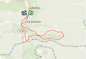
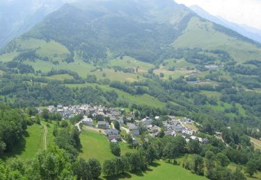
Ruta Senderismo de 8,5 km a descubrir en Occitania, Altos-Pirineos, Hèches. Esta ruta ha sido propuesta por mitch1952.
Descripción
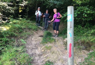
Randonnée effectuée en sens anti horaire , sens contraire du balisage local. Retour le long du canal de la Neste
Sortie commune du 17 juin 2022
Puntos de interés
Localización
País:
France
Región :
Occitania
Departamento/provincia :
Altos-Pirineos
Municipio :
Hèches
Localidad:
Unknown
Salida:(Dec)
Salida:(UTM)
286311 ; 4764239 (31T) N.
Comentarios
Excursiones cerca
![Excursión Senderismo Hèches - Rebouc G4 - Photo](https://media.geolcdn.com/t/375/260/6afd6a38-38b1-4921-be66-02c17ac9ac6f.jpg&format=jpg&maxdim=2)
![Senderismo Senderismo](https://static1.geolcdn.com/sitytour/trail-icons/101.png)
Rebouc G4
Senderismo
Muy fácil
Hèches,
Occitania,
Altos-Pirineos,
France
![](/images/other/stat-length.png)
4,4 km | 5,9 km-effort
1h 10min
![](https://static1.geolcdn.com/siteimages/upload/files/16400158638029165_repeat_loop_refresh_sync_direction_icon.png)
Sí
![Excursión Senderismo Esparros - FEU 2015 - Etape 3 - Photo](https://media.geolcdn.com/t/375/260/ext.jpg?maxdim=2&url=https%3A%2F%2Fstatic1.geolcdn.com%2Fsiteimages%2Fupload%2Ffiles%2F1553511878bg_sport_marche.png)
![Senderismo Senderismo](https://static1.geolcdn.com/sitytour/trail-icons/101.png)
FEU 2015 - Etape 3
Senderismo
Fácil
(3)
Esparros,
Occitania,
Altos-Pirineos,
France
![](/images/other/stat-length.png)
23 km | 32 km-effort
6h 45min
![](https://static1.geolcdn.com/siteimages/upload/files/16400158638029165_repeat_loop_refresh_sync_direction_icon.png)
No
![Excursión Senderismo Lortet - FEU 2015 - Etape 2 - Photo](https://media.geolcdn.com/t/375/260/ext.jpg?maxdim=2&url=https%3A%2F%2Fstatic1.geolcdn.com%2Fsiteimages%2Fupload%2Ffiles%2F1553511878bg_sport_marche.png)
![Senderismo Senderismo](https://static1.geolcdn.com/sitytour/trail-icons/101.png)
FEU 2015 - Etape 2
Senderismo
Fácil
(1)
Lortet,
Occitania,
Altos-Pirineos,
France
![](/images/other/stat-length.png)
7,8 km | 12,5 km-effort
2h 34min
![](https://static1.geolcdn.com/siteimages/upload/files/16400158638029165_repeat_loop_refresh_sync_direction_icon.png)
No
![Excursión Senderismo Esparros - Pacte des loups - Photo](https://media.geolcdn.com/t/375/260/ext.jpg?maxdim=2&url=https%3A%2F%2Fstatic1.geolcdn.com%2Fsiteimages%2Fupload%2Ffiles%2F1553511878bg_sport_marche.png)
![Senderismo Senderismo](https://static1.geolcdn.com/sitytour/trail-icons/101.png)
Pacte des loups
Senderismo
Medio
(2)
Esparros,
Occitania,
Altos-Pirineos,
France
![](/images/other/stat-length.png)
10,9 km | 18 km-effort
Desconocido
![](https://static1.geolcdn.com/siteimages/upload/files/16400158638029165_repeat_loop_refresh_sync_direction_icon.png)
Sí
![Excursión Senderismo Hèches - REBOUC sortie commune LPC trace revue et corrigée](https://media.geolcdn.com/t/375/260/8e9dfb66-dcd3-4aee-b1eb-ee2219a413be.jpg&format=jpg&maxdim=2)
![Senderismo Senderismo](https://static1.geolcdn.com/sitytour/trail-icons/101.png)
REBOUC sortie commune LPC trace revue et corrigée "3822705"
Senderismo
Medio
Hèches,
Occitania,
Altos-Pirineos,
France
![](/images/other/stat-length.png)
6,1 km | 8,5 km-effort
1h 55min
![](https://static1.geolcdn.com/siteimages/upload/files/16400158638029165_repeat_loop_refresh_sync_direction_icon.png)
Sí
![Excursión Senderismo Sarrancolin - plo de Berdaoulou - Photo](https://media.geolcdn.com/t/375/260/2313cc1f-dd1d-4b74-9e32-b9528b3e7a68.jpg&format=jpg&maxdim=2)
![Senderismo Senderismo](https://static1.geolcdn.com/sitytour/trail-icons/101.png)
plo de Berdaoulou
Senderismo
Medio
Sarrancolin,
Occitania,
Altos-Pirineos,
France
![](/images/other/stat-length.png)
12,9 km | 26 km-effort
7h 12min
![](https://static1.geolcdn.com/siteimages/upload/files/16400158638029165_repeat_loop_refresh_sync_direction_icon.png)
Sí
![Excursión A pie Lortet - Voie d'Aure - Photo](https://media.geolcdn.com/t/375/260/34e6b7ee-1da4-4e0c-9a42-89afb2436ef7.jpeg&format=jpg&maxdim=2)
![A pie A pie](https://static1.geolcdn.com/sitytour/trail-icons/100.png)
Voie d'Aure
A pie
Muy difícil
Lortet,
Occitania,
Altos-Pirineos,
France
![](/images/other/stat-length.png)
56 km | 87 km-effort
19h 50min
![](https://static1.geolcdn.com/siteimages/upload/files/16400158638029165_repeat_loop_refresh_sync_direction_icon.png)
No
![Excursión Senderismo Esparros - Pacte des loups - Photo](https://media.geolcdn.com/t/375/260/c60a69e3-27b6-4618-8750-9159e2522e05.jpg&format=jpg&maxdim=2)
![Senderismo Senderismo](https://static1.geolcdn.com/sitytour/trail-icons/101.png)
Pacte des loups
Senderismo
Medio
Esparros,
Occitania,
Altos-Pirineos,
France
![](/images/other/stat-length.png)
7,8 km | 13,3 km-effort
5h 27min
![](https://static1.geolcdn.com/siteimages/upload/files/16400158638029165_repeat_loop_refresh_sync_direction_icon.png)
Sí
![Excursión Bici de montaña Sarrancolin - Le col d'Azet en VTT - Photo](https://media.geolcdn.com/t/375/260/ext.jpg?maxdim=2&url=https%3A%2F%2Fservices.sitytrail.com%2FGeolivesWS%2FDownloadMedia.ashx%3FTrailID%3D101155%26Media%3D645_4.jpg)
![Bici de montaña Bici de montaña](https://static1.geolcdn.com/sitytour/trail-icons/202.png)
Le col d'Azet en VTT
Bici de montaña
Muy difícil
Sarrancolin,
Occitania,
Altos-Pirineos,
France
![](/images/other/stat-length.png)
28 km | 43 km-effort
2h 30min
![](https://static1.geolcdn.com/siteimages/upload/files/16400158638029165_repeat_loop_refresh_sync_direction_icon.png)
No