![](/images/other/stat-length.png)
![Excursión Senderismo Baden - Baden (Moulin de Pomper - Port Blanc - Toulindac - Kerdelan - Keriboul - Penmern) - Photo](https://media.geolcdn.com/t/1900/400/ext.pjpeg?maxdim=2&url=https%3A%2F%2Fstatic1.geolcdn.com%2Fsiteimages%2Fupload%2Ffiles%2F1553511878bg_sport_marche.png)
Baden (Moulin de Pomper - Port Blanc - Toulindac - Kerdelan - Keriboul - Penmern)
PAM2235
Usuario
![Longitud](/images/other/stat-length.png)
Longitud
10,5 km
![Altitud máxima](https://static1.geolcdn.com/siteimages/upload/files/1508320355ic_sort_altitude_max_24dp.png)
Altitud máxima
23 m
![Desnivel positivo](https://static1.geolcdn.com/siteimages/upload/files/1508320355ic_sort_den_pos_24dp.png)
Desnivel positivo
113 m
![Km-Effort](/images/other/stat-length.png)
Km-Effort
12 km
![Altitud mínima](https://static1.geolcdn.com/siteimages/upload/files/1508320355ic_sort_altitude_min_24dp.png)
Altitud mínima
0 m
![Desnivel negativo](https://static1.geolcdn.com/siteimages/upload/files/1508320355ic_sort_den_neg_24dp.png)
Desnivel negativo
113 m
![Boucle](https://static1.geolcdn.com/siteimages/upload/files/16400158638029165_repeat_loop_refresh_sync_direction_icon.png)
Boucle
Sí
Fecha de creación :
2020-10-01 12:00:00.319
Última modificación :
2021-03-05 15:35:57.496
![Senderismo](https://static1.geolcdn.com/sitytour/trail-icons/101.png)
2h30
Dificultad : Fácil
![Escanee este código QR para abrir la excursión en la aplicación SityTrail](https://capi.geolives.com/qq0zvz2zws4bq2lad0pu/sitytour/trails/2566282/qr.png?size=200)
Aplicación GPS de excursión GRATIS
A propósito
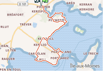
Ruta Senderismo de 10,5 km a descubrir en Bretaña, Morbihan, Baden. Esta ruta ha sido propuesta por PAM2235.
Descripción
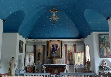
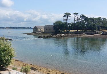
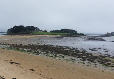
Circuit de 10,5 km au départ du parking de Kerhervé, situé à proximité de l'intersection de la D101 et de la D316. Aller par le sentier côtier (GR 34) jusqu'à Kerdelan, en passant par Port Blanc. Retour par Keriboul et Penmern.
Localización
País:
France
Región :
Bretaña
Departamento/provincia :
Morbihan
Municipio :
Baden
Localidad:
Unknown
Salida:(Dec)
Salida:(UTM)
509617 ; 5274208 (30T) N.
Comentarios
Excursiones cerca
![Excursión Senderismo Larmor-Baden - LARMOR-BADEN_PEN-EN-TOUL_BERDER - Photo](https://media.geolcdn.com/t/375/260/006d768a-8f9f-48de-b1ea-c2f886dc8e57.jpg&format=jpg&maxdim=2)
![Senderismo Senderismo](https://static1.geolcdn.com/sitytour/trail-icons/101.png)
LARMOR-BADEN_PEN-EN-TOUL_BERDER
Senderismo
Fácil
(2)
Larmor-Baden,
Bretaña,
Morbihan,
France
![](/images/other/stat-length.png)
10,9 km | 12,3 km-effort
2h 23min
![](https://static1.geolcdn.com/siteimages/upload/files/16400158638029165_repeat_loop_refresh_sync_direction_icon.png)
Sí
![Excursión Senderismo Baden - Ile aux Moines - Photo](https://media.geolcdn.com/t/375/260/ext.jpg?maxdim=2&url=https%3A%2F%2Fservices.sitytrail.com%2FGeolivesWS%2FDownloadMedia.ashx%3FTrailID%3D204495%26Media%3Dfix__20130708163141.jpg)
![Senderismo Senderismo](https://static1.geolcdn.com/sitytour/trail-icons/101.png)
Ile aux Moines
Senderismo
Fácil
(1)
Baden,
Bretaña,
Morbihan,
France
![](/images/other/stat-length.png)
19,8 km | 22 km-effort
4h 53min
![](https://static1.geolcdn.com/siteimages/upload/files/16400158638029165_repeat_loop_refresh_sync_direction_icon.png)
No
![Excursión Carrera Larmor-Baden - Larmor Baden - Photo](https://media.geolcdn.com/t/375/260/ext.jpg?maxdim=2&url=https%3A%2F%2Fservices.sitytrail.com%2FGeolivesWS%2FDownloadMedia.ashx%3FTrailID%3D224679%26Media%3Dfix__20131001111052.jpg)
![Carrera Carrera](https://static1.geolcdn.com/sitytour/trail-icons/103.png)
Larmor Baden
Carrera
Medio
(1)
Larmor-Baden,
Bretaña,
Morbihan,
France
![](/images/other/stat-length.png)
5 km | 5,6 km-effort
54min
![](https://static1.geolcdn.com/siteimages/upload/files/16400158638029165_repeat_loop_refresh_sync_direction_icon.png)
Sí
![Excursión Bicicleta Arradon - f-frankrijk-rondje-morbihan - Photo](https://media.geolcdn.com/t/375/260/ext.jpg?maxdim=2&url=https%3A%2F%2Fstatic1.geolcdn.com%2Fsiteimages%2Fupload%2Ffiles%2F1524743154velo.jpg)
![Bicicleta Bicicleta](https://static1.geolcdn.com/sitytour/trail-icons/200.png)
f-frankrijk-rondje-morbihan
Bicicleta
Muy fácil
(2)
Arradon,
Bretaña,
Morbihan,
France
![](/images/other/stat-length.png)
36 km | 42 km-effort
Desconocido
![](https://static1.geolcdn.com/siteimages/upload/files/16400158638029165_repeat_loop_refresh_sync_direction_icon.png)
Sí
![Excursión Senderismo Ploeren - Ploeren - Photo](https://media.geolcdn.com/t/375/260/ext.jpg?maxdim=2&url=https%3A%2F%2Fstatic1.geolcdn.com%2Fsiteimages%2Fupload%2Ffiles%2F1553511878bg_sport_marche.png)
![Senderismo Senderismo](https://static1.geolcdn.com/sitytour/trail-icons/101.png)
Ploeren
Senderismo
Muy fácil
(1)
Ploeren,
Bretaña,
Morbihan,
France
![](/images/other/stat-length.png)
5,4 km | 6,1 km-effort
1h 27min
![](https://static1.geolcdn.com/siteimages/upload/files/16400158638029165_repeat_loop_refresh_sync_direction_icon.png)
Sí
![Excursión Senderismo Île-aux-Moines - moines - Photo](https://media.geolcdn.com/t/375/260/ext.jpg?maxdim=2&url=https%3A%2F%2Fstatic1.geolcdn.com%2Fsiteimages%2Fupload%2Ffiles%2F1553511878bg_sport_marche.png)
![Senderismo Senderismo](https://static1.geolcdn.com/sitytour/trail-icons/101.png)
moines
Senderismo
Fácil
(2)
Île-aux-Moines,
Bretaña,
Morbihan,
France
![](/images/other/stat-length.png)
18,2 km | 21 km-effort
4h 7min
![](https://static1.geolcdn.com/siteimages/upload/files/16400158638029165_repeat_loop_refresh_sync_direction_icon.png)
No
![Excursión Senderismo Baden - PR_56_Baden_AB_05_Circuit4a_Anse-Du-Moustran_20240908 - Photo](https://media.geolcdn.com/t/375/260/a2cc3589-c64a-4b8b-8252-b3acfcad70d8.jpg&format=jpg&maxdim=2)
![Senderismo Senderismo](https://static1.geolcdn.com/sitytour/trail-icons/101.png)
PR_56_Baden_AB_05_Circuit4a_Anse-Du-Moustran_20240908
Senderismo
Fácil
Baden,
Bretaña,
Morbihan,
France
![](/images/other/stat-length.png)
8,1 km | 9,3 km-effort
1h 43min
![](https://static1.geolcdn.com/siteimages/upload/files/16400158638029165_repeat_loop_refresh_sync_direction_icon.png)
Sí
![Excursión Senderismo Larmor-Baden - PR_56_Larmor-Baden_BA_02_Circuit4a_Tour-De-Berder-Et-Du-Marais_20240717 - Photo](https://media.geolcdn.com/t/375/260/70ea2a1f-db2c-4745-8120-1285e1dd4505.jpg&format=jpg&maxdim=2)
![Senderismo Senderismo](https://static1.geolcdn.com/sitytour/trail-icons/101.png)
PR_56_Larmor-Baden_BA_02_Circuit4a_Tour-De-Berder-Et-Du-Marais_20240717
Senderismo
Muy fácil
Larmor-Baden,
Bretaña,
Morbihan,
France
![](/images/other/stat-length.png)
9,6 km | 10,8 km-effort
1h 55min
![](https://static1.geolcdn.com/siteimages/upload/files/16400158638029165_repeat_loop_refresh_sync_direction_icon.png)
Sí
![Excursión Senderismo Baden - PR_56_Baden_DA_04_Circuit4a_Pointe-De-Locmiquel_20240317 - Photo](https://media.geolcdn.com/t/375/260/28b1849b-0798-4b99-85e4-eaa3b59fa830.jpg&format=jpg&maxdim=2)
![Senderismo Senderismo](https://static1.geolcdn.com/sitytour/trail-icons/101.png)
PR_56_Baden_DA_04_Circuit4a_Pointe-De-Locmiquel_20240317
Senderismo
Difícil
Baden,
Bretaña,
Morbihan,
France
![](/images/other/stat-length.png)
12 km | 14 km-effort
3h 11min
![](https://static1.geolcdn.com/siteimages/upload/files/16400158638029165_repeat_loop_refresh_sync_direction_icon.png)
Sí