![](/images/other/stat-length.png)
![Excursión Senderismo Sisteron - Rocher de Baume - Photo](https://media.geolcdn.com/t/1900/400/749307ec-c35c-4209-a01b-d1a95a3c6fd6.jpg&format=pjpeg&maxdim=2)
Rocher de Baume
nadd73
Usuario GUIDE
![Longitud](/images/other/stat-length.png)
![Altitud máxima](https://static1.geolcdn.com/siteimages/upload/files/1508320355ic_sort_altitude_max_24dp.png)
![Desnivel positivo](https://static1.geolcdn.com/siteimages/upload/files/1508320355ic_sort_den_pos_24dp.png)
![Km-Effort](/images/other/stat-length.png)
![Altitud mínima](https://static1.geolcdn.com/siteimages/upload/files/1508320355ic_sort_altitude_min_24dp.png)
![Desnivel negativo](https://static1.geolcdn.com/siteimages/upload/files/1508320355ic_sort_den_neg_24dp.png)
![Boucle](https://static1.geolcdn.com/siteimages/upload/files/16400158638029165_repeat_loop_refresh_sync_direction_icon.png)
![Senderismo](https://static1.geolcdn.com/sitytour/trail-icons/101.png)
3h08
Dificultad : Medio
![Escanee este código QR para abrir la excursión en la aplicación SityTrail](https://capi.geolives.com/qq0zvz2zws4bq2lad0pu/sitytour/trails/2564050/qr.png?size=200)
Aplicación GPS de excursión GRATIS
A propósito
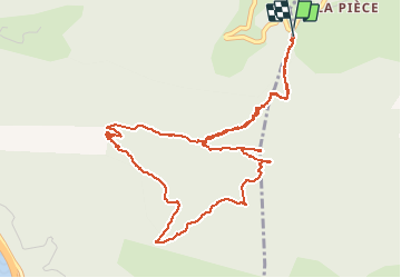
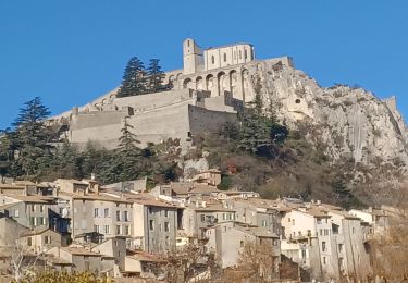
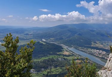
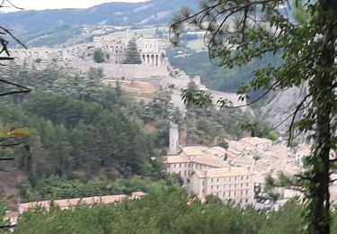
Ruta Senderismo de 6,3 km a descubrir en Provenza-Alpes-Costa Azul, Alpes de Alta Provenza, Sisteron. Esta ruta ha sido propuesta por nadd73.
Descripción
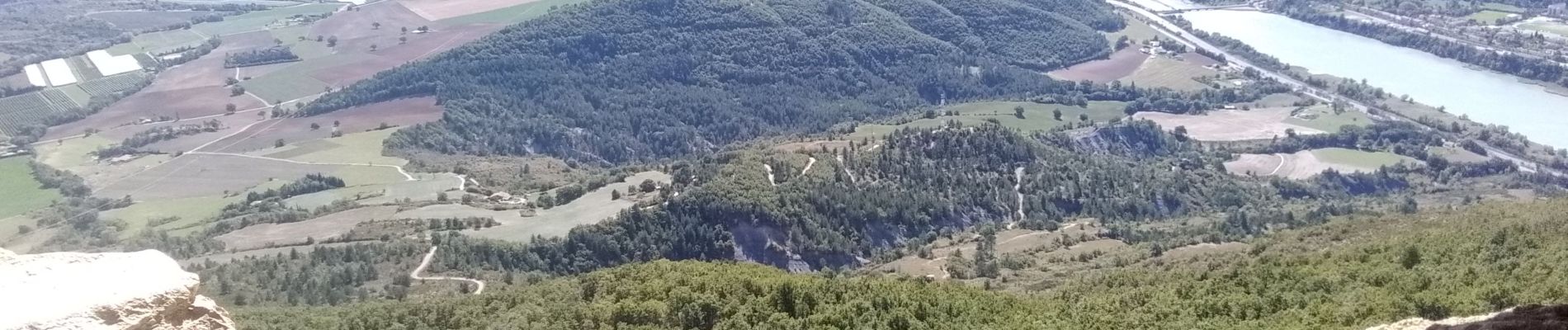
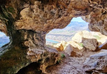
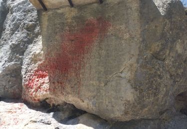
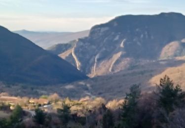
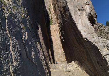
Du col de mézien, monter sur la crête faire le sommet. Revenir à l'embranchement et descendre Sud (câbles : aérien mais aisé) pour passer dans la grotte du trou d'argent (lampe Utile) quelques petites fenêtres. Très belle vue. Descendre jusqu'à 800m d'altitude pour remonter sur la crête par un sentier assez bien marqué (marques rouges et bleues) arête aérienne.
Pour personne expérimentée.
Localización
Comentarios
Excursiones cerca
![Excursión Senderismo Sisteron - SISTERON . CHAMP BRANCOU . LA COLLE . LE MOLLARD O L S - Photo](https://media.geolcdn.com/t/375/260/cecdacbf-083e-4c48-a080-b152844df49c.jpg&format=jpg&maxdim=2)
![Senderismo Senderismo](https://static1.geolcdn.com/sitytour/trail-icons/101.png)
Senderismo
![](/images/other/stat-length.png)
![](https://static1.geolcdn.com/siteimages/upload/files/16400158638029165_repeat_loop_refresh_sync_direction_icon.png)
![Excursión Senderismo Sisteron - Le Trou de l'Argent Via Sisteron - Photo](https://media.geolcdn.com/t/375/260/bfa6b4fb-8efb-4bbe-ae9d-f38ed475646a.jpg&format=jpg&maxdim=2)
![Senderismo Senderismo](https://static1.geolcdn.com/sitytour/trail-icons/101.png)
Senderismo
![](/images/other/stat-length.png)
![](https://static1.geolcdn.com/siteimages/upload/files/16400158638029165_repeat_loop_refresh_sync_direction_icon.png)
![Excursión Senderismo Saint-Geniez - Pierre écrite et montagne de Gache - Photo](https://media.geolcdn.com/t/375/260/7a1ca822-6c04-425e-94b9-5be1080d03a0.jpg&format=jpg&maxdim=2)
![Senderismo Senderismo](https://static1.geolcdn.com/sitytour/trail-icons/101.png)
Senderismo
![](/images/other/stat-length.png)
![](https://static1.geolcdn.com/siteimages/upload/files/16400158638029165_repeat_loop_refresh_sync_direction_icon.png)
![Excursión Senderismo Entrepierres - SAINT GENIEZ . LE MOURRE DE GACHE PAR LA FONT DE MEGE N - Photo](https://media.geolcdn.com/t/375/260/5d853fdd-5713-4858-a535-57b1bf5db08d.jpg&format=jpg&maxdim=2)
![Senderismo Senderismo](https://static1.geolcdn.com/sitytour/trail-icons/101.png)
Senderismo
![](/images/other/stat-length.png)
![](https://static1.geolcdn.com/siteimages/upload/files/16400158638029165_repeat_loop_refresh_sync_direction_icon.png)
![Excursión Senderismo Sisteron - 05 trop argent 02.08.23 - Photo](https://media.geolcdn.com/t/375/260/2f52f635-2a11-4916-a9f5-f3227f3b1529.jpg&format=jpg&maxdim=2)
![Senderismo Senderismo](https://static1.geolcdn.com/sitytour/trail-icons/101.png)
Senderismo
![](/images/other/stat-length.png)
![](https://static1.geolcdn.com/siteimages/upload/files/16400158638029165_repeat_loop_refresh_sync_direction_icon.png)
![Excursión Senderismo Sisteron - SISTERON. SUR LA ROUTE DU TEMPS 2. O L M S - Photo](https://media.geolcdn.com/t/375/260/20c8aa54-ba97-4a73-8287-049a48bb92a8.jpg&format=jpg&maxdim=2)
![Senderismo Senderismo](https://static1.geolcdn.com/sitytour/trail-icons/101.png)
Senderismo
![](/images/other/stat-length.png)
![](https://static1.geolcdn.com/siteimages/upload/files/16400158638029165_repeat_loop_refresh_sync_direction_icon.png)
![Excursión Senderismo Sisteron - BEVONS crêtes de Chapage o l s m - Photo](https://media.geolcdn.com/t/375/260/06496741-537d-4e32-9a57-13673b07b6c5.jpg&format=jpg&maxdim=2)
![Senderismo Senderismo](https://static1.geolcdn.com/sitytour/trail-icons/101.png)
Senderismo
![](/images/other/stat-length.png)
![](https://static1.geolcdn.com/siteimages/upload/files/16400158638029165_repeat_loop_refresh_sync_direction_icon.png)
![Excursión Senderismo Sisteron - Trou de l'argent - Photo](https://media.geolcdn.com/t/375/260/efd53f67-e8d5-4c71-be71-21c3c1bbbb50.jpg&format=jpg&maxdim=2)
![Senderismo Senderismo](https://static1.geolcdn.com/sitytour/trail-icons/101.png)
Senderismo
![](/images/other/stat-length.png)
![](https://static1.geolcdn.com/siteimages/upload/files/16400158638029165_repeat_loop_refresh_sync_direction_icon.png)
![Excursión Senderismo Sisteron - SISTERON. Le Mollard . Col S Pierre o n - Photo](https://media.geolcdn.com/t/375/260/439b9630-cce8-40a1-b207-cf2467f89777.jpg&format=jpg&maxdim=2)
![Senderismo Senderismo](https://static1.geolcdn.com/sitytour/trail-icons/101.png)
Senderismo
![](/images/other/stat-length.png)
![](https://static1.geolcdn.com/siteimages/upload/files/16400158638029165_repeat_loop_refresh_sync_direction_icon.png)