![](/images/other/stat-length.png)
![Excursión Senderismo Gresse-en-Vercors - Vercors jour 3: Pas des Bachassons à - Photo](https://media.geolcdn.com/t/1900/400/ext.pjpeg?maxdim=2&url=https%3A%2F%2Fstatic1.geolcdn.com%2Fsiteimages%2Fupload%2Ffiles%2F1553511878bg_sport_marche.png)
Vercors jour 3: Pas des Bachassons à
MathieuBourgois
Usuario
![Longitud](/images/other/stat-length.png)
Longitud
19,7 km
![Altitud máxima](https://static1.geolcdn.com/siteimages/upload/files/1508320355ic_sort_altitude_max_24dp.png)
Altitud máxima
1881 m
![Desnivel positivo](https://static1.geolcdn.com/siteimages/upload/files/1508320355ic_sort_den_pos_24dp.png)
Desnivel positivo
333 m
![Km-Effort](/images/other/stat-length.png)
Km-Effort
26 km
![Altitud mínima](https://static1.geolcdn.com/siteimages/upload/files/1508320355ic_sort_altitude_min_24dp.png)
Altitud mínima
1309 m
![Desnivel negativo](https://static1.geolcdn.com/siteimages/upload/files/1508320355ic_sort_den_neg_24dp.png)
Desnivel negativo
811 m
![Boucle](https://static1.geolcdn.com/siteimages/upload/files/16400158638029165_repeat_loop_refresh_sync_direction_icon.png)
Boucle
No
Fecha de creación :
2020-09-15 09:55:45.726
Última modificación :
2020-09-15 10:46:22.657
![Senderismo](https://static1.geolcdn.com/sitytour/trail-icons/101.png)
6m
Dificultad : Fácil
![Escanee este código QR para abrir la excursión en la aplicación SityTrail](https://capi.geolives.com/qq0zvz2zws4bq2lad0pu/sitytour/trails/2551478/qr.png?size=200)
Aplicación GPS de excursión GRATIS
A propósito
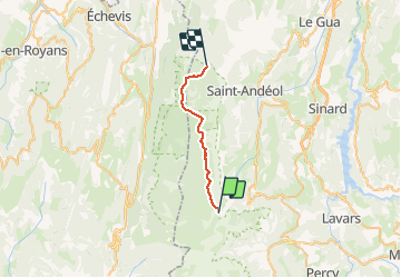
Ruta Senderismo de 19,7 km a descubrir en Auvergne-Rhône-Alpes, Isère, Gresse-en-Vercors. Esta ruta ha sido propuesta por MathieuBourgois.
Descripción
Pas des Bachassons: 500m et 0D
Fontaine de Chau 5km et 30D
Refuge Jasse du Play 7.6km et 80D
Puit de Darbounouse
Cabane de Carette: 20km et 333D
Localización
País:
France
Región :
Auvergne-Rhône-Alpes
Departamento/provincia :
Isère
Municipio :
Gresse-en-Vercors
Localidad:
Unknown
Salida:(Dec)
Salida:(UTM)
699140 ; 4969780 (31T) N.
Comentarios
Excursiones cerca
![Excursión Senderismo Saint-Michel-les-Portes - Grand Ceymont par la face Sud - Photo](https://media.geolcdn.com/t/375/260/d58be866-4722-407f-9e9c-e7428ea96660.jpg&format=jpg&maxdim=2)
![Senderismo Senderismo](https://static1.geolcdn.com/sitytour/trail-icons/101.png)
Grand Ceymont par la face Sud
Senderismo
Difícil
(1)
Saint-Michel-les-Portes,
Auvergne-Rhône-Alpes,
Isère,
France
![](/images/other/stat-length.png)
14,3 km | 31 km-effort
6h 0min
![](https://static1.geolcdn.com/siteimages/upload/files/16400158638029165_repeat_loop_refresh_sync_direction_icon.png)
Sí
![Excursión Senderismo Gresse-en-Vercors - Quinquambaye - crête du Brisou - Photo](https://media.geolcdn.com/t/375/260/686aed71-19ef-4a34-8333-a2b65dd9c4d5.jpg&format=jpg&maxdim=2)
![Senderismo Senderismo](https://static1.geolcdn.com/sitytour/trail-icons/101.png)
Quinquambaye - crête du Brisou
Senderismo
Medio
(1)
Gresse-en-Vercors,
Auvergne-Rhône-Alpes,
Isère,
France
![](/images/other/stat-length.png)
12,1 km | 23 km-effort
6h 28min
![](https://static1.geolcdn.com/siteimages/upload/files/16400158638029165_repeat_loop_refresh_sync_direction_icon.png)
Sí
![Excursión Senderismo Gresse-en-Vercors - Traversée du Rocher du Baconnet - Photo](https://media.geolcdn.com/t/375/260/ext.jpg?maxdim=2&url=https%3A%2F%2Fservices.sitytrail.com%2FGeolivesWS%2FDownloadMedia.ashx%3FTrailID%3D105962%26Media%3D10040_1.jpg)
![Senderismo Senderismo](https://static1.geolcdn.com/sitytour/trail-icons/101.png)
Traversée du Rocher du Baconnet
Senderismo
Fácil
(2)
Gresse-en-Vercors,
Auvergne-Rhône-Alpes,
Isère,
France
![](/images/other/stat-length.png)
10,7 km | 18,9 km-effort
5h 0min
![](https://static1.geolcdn.com/siteimages/upload/files/16400158638029165_repeat_loop_refresh_sync_direction_icon.png)
Sí
![Excursión Senderismo Chichilianne - La Fontaine Pourrie - Hauts Plateaux Sud du Vercors - Photo](https://media.geolcdn.com/t/375/260/ext.jpg?maxdim=2&url=https%3A%2F%2Fservices.sitytrail.com%2FGeolivesWS%2FDownloadMedia.ashx%3FTrailID%3D105613%26Media%3D9383_1.jpg)
![Senderismo Senderismo](https://static1.geolcdn.com/sitytour/trail-icons/101.png)
La Fontaine Pourrie - Hauts Plateaux Sud du Vercors
Senderismo
Medio
(2)
Chichilianne,
Auvergne-Rhône-Alpes,
Isère,
France
![](/images/other/stat-length.png)
19,4 km | 33 km-effort
7h 45min
![](https://static1.geolcdn.com/siteimages/upload/files/16400158638029165_repeat_loop_refresh_sync_direction_icon.png)
Sí
![Excursión Senderismo Gresse-en-Vercors - traversée Sud nord du Grand Veymont - Photo](https://media.geolcdn.com/t/375/260/3004a1b5-ea0f-48e3-8863-72e77652ad4d.jpg&format=jpg&maxdim=2)
![Senderismo Senderismo](https://static1.geolcdn.com/sitytour/trail-icons/101.png)
traversée Sud nord du Grand Veymont
Senderismo
Difícil
Gresse-en-Vercors,
Auvergne-Rhône-Alpes,
Isère,
France
![](/images/other/stat-length.png)
26 km | 40 km-effort
10h 42min
![](https://static1.geolcdn.com/siteimages/upload/files/16400158638029165_repeat_loop_refresh_sync_direction_icon.png)
No
![Excursión Senderismo Chichilianne - 14923554-Tour du Mont Aiguille - Photo](https://media.geolcdn.com/t/375/260/ext.jpg?maxdim=2&url=https%3A%2F%2Fstatic1.geolcdn.com%2Fsiteimages%2Fupload%2Ffiles%2F1553511878bg_sport_marche.png)
![Senderismo Senderismo](https://static1.geolcdn.com/sitytour/trail-icons/101.png)
14923554-Tour du Mont Aiguille
Senderismo
Muy difícil
(1)
Chichilianne,
Auvergne-Rhône-Alpes,
Isère,
France
![](/images/other/stat-length.png)
17,7 km | 33 km-effort
7h 27min
![](https://static1.geolcdn.com/siteimages/upload/files/16400158638029165_repeat_loop_refresh_sync_direction_icon.png)
Sí
![Excursión Senderismo Saint-Michel-les-Portes - Tour du Mont Aiguille - Photo](https://media.geolcdn.com/t/375/260/13641da4-549e-49b9-8e23-d4a17f7e4345.jpg&format=jpg&maxdim=2)
![Senderismo Senderismo](https://static1.geolcdn.com/sitytour/trail-icons/101.png)
Tour du Mont Aiguille
Senderismo
Difícil
Saint-Michel-les-Portes,
Auvergne-Rhône-Alpes,
Isère,
France
![](/images/other/stat-length.png)
18,5 km | 34 km-effort
6h 20min
![](https://static1.geolcdn.com/siteimages/upload/files/16400158638029165_repeat_loop_refresh_sync_direction_icon.png)
Sí
![Excursión Senderismo Gresse-en-Vercors - le grand veymont depuis gresse en vercors et par le pas de la ville - Photo](https://media.geolcdn.com/t/375/260/ext.jpg?maxdim=2&url=https%3A%2F%2Fstatic1.geolcdn.com%2Fsiteimages%2Fupload%2Ffiles%2F1553511878bg_sport_marche.png)
![Senderismo Senderismo](https://static1.geolcdn.com/sitytour/trail-icons/101.png)
le grand veymont depuis gresse en vercors et par le pas de la ville
Senderismo
Medio
(1)
Gresse-en-Vercors,
Auvergne-Rhône-Alpes,
Isère,
France
![](/images/other/stat-length.png)
10,9 km | 25 km-effort
4h 53min
![](https://static1.geolcdn.com/siteimages/upload/files/16400158638029165_repeat_loop_refresh_sync_direction_icon.png)
Sí
![Excursión Raquetas de nieve Chichilianne - chichilianne archiane - Photo](https://media.geolcdn.com/t/375/260/ext.jpg?maxdim=2&url=https%3A%2F%2Fstatic1.geolcdn.com%2Fsiteimages%2Fupload%2Ffiles%2F1524743153raquette.jpg)
![Raquetas de nieve Raquetas de nieve](https://static1.geolcdn.com/sitytour/trail-icons/504.png)
chichilianne archiane
Raquetas de nieve
Medio
(1)
Chichilianne,
Auvergne-Rhône-Alpes,
Isère,
France
![](/images/other/stat-length.png)
18,9 km | 32 km-effort
8h 0min
![](https://static1.geolcdn.com/siteimages/upload/files/16400158638029165_repeat_loop_refresh_sync_direction_icon.png)
No