![](/images/other/stat-length.png)
![Excursión Senderismo Vallouise-Pelvoux - 2020-09-10 Marche Vallouise Refuge des bans - Photo](https://media.geolcdn.com/t/1900/400/a7de6a77-c13c-4149-8601-9d553c401f68.jpg&format=pjpeg&maxdim=2)
2020-09-10 Marche Vallouise Refuge des bans
holtzv
Usuario GUIDE
![Longitud](/images/other/stat-length.png)
![Altitud máxima](https://static1.geolcdn.com/siteimages/upload/files/1508320355ic_sort_altitude_max_24dp.png)
![Desnivel positivo](https://static1.geolcdn.com/siteimages/upload/files/1508320355ic_sort_den_pos_24dp.png)
![Km-Effort](/images/other/stat-length.png)
![Altitud mínima](https://static1.geolcdn.com/siteimages/upload/files/1508320355ic_sort_altitude_min_24dp.png)
![Desnivel negativo](https://static1.geolcdn.com/siteimages/upload/files/1508320355ic_sort_den_neg_24dp.png)
![Boucle](https://static1.geolcdn.com/siteimages/upload/files/16400158638029165_repeat_loop_refresh_sync_direction_icon.png)
![Senderismo](https://static1.geolcdn.com/sitytour/trail-icons/101.png)
4h39
Dificultad : Muy fácil
![Escanee este código QR para abrir la excursión en la aplicación SityTrail](https://capi.geolives.com/qq0zvz2zws4bq2lad0pu/sitytour/trails/2545857/qr.png?size=200)
Aplicación GPS de excursión GRATIS
A propósito
Ruta Senderismo de 10,2 km a descubrir en Provenza-Alpes-Costa Azul, Altos Alpes, Vallouise-Pelvoux. Esta ruta ha sido propuesta por holtzv.
Descripción
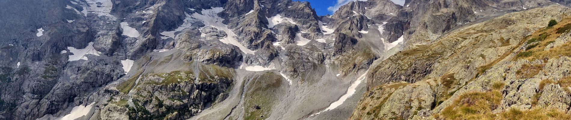
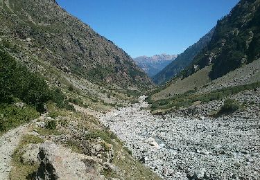
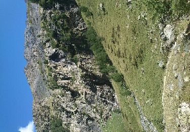
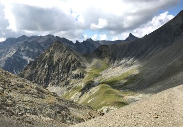
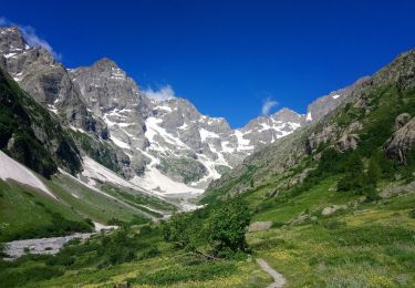
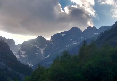
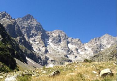
Ascension rapide vers le Refuge des Bans (alt 2083m). Un petit sentier à côté de ce dernier permet de monter plus haut vers le Peyre Arguet. On s’arrête après 300m de dénivelé pour admirer la vue sur les différents glaciers et pics des Bans. Repas au refuge.
Localización
Comentarios
Excursiones cerca
![Excursión Senderismo Vallouise-Pelvoux - refuge des bancs - Photo](https://media.geolcdn.com/t/375/260/ext.jpg?maxdim=2&url=https%3A%2F%2Fservices.sitytrail.com%2FGeolivesWS%2FDownloadMedia.ashx%3FTrailID%3D145357%26Media%3D20120810141346.jpeg)
![Senderismo Senderismo](https://static1.geolcdn.com/sitytour/trail-icons/101.png)
Senderismo
![](/images/other/stat-length.png)
![](https://static1.geolcdn.com/siteimages/upload/files/16400158638029165_repeat_loop_refresh_sync_direction_icon.png)
![Excursión Senderismo Vallouise-Pelvoux - vallon de la selle cabane du jas Lacroix - Photo](https://media.geolcdn.com/t/375/260/ext.jpg?maxdim=2&url=https%3A%2F%2Fservices.sitytrail.com%2FGeolivesWS%2FDownloadMedia.ashx%3FTrailID%3D146951%26Media%3D20120814161452.jpeg)
![Senderismo Senderismo](https://static1.geolcdn.com/sitytour/trail-icons/101.png)
Senderismo
![](/images/other/stat-length.png)
![](https://static1.geolcdn.com/siteimages/upload/files/16400158638029165_repeat_loop_refresh_sync_direction_icon.png)
![Excursión Senderismo Vallouise-Pelvoux - Tour des Écrins J4 - Photo](https://media.geolcdn.com/t/375/260/949d119e-a643-4666-a93c-4787f5322f25.jpg&format=jpg&maxdim=2)
![Senderismo Senderismo](https://static1.geolcdn.com/sitytour/trail-icons/101.png)
Senderismo
![](/images/other/stat-length.png)
![](https://static1.geolcdn.com/siteimages/upload/files/16400158638029165_repeat_loop_refresh_sync_direction_icon.png)
![Excursión Senderismo Vallouise-Pelvoux - refuge des bans - Photo](https://media.geolcdn.com/t/375/260/de2be7cb-6449-4b5e-a967-ba73015f1518.jpg&format=jpg&maxdim=2)
![Senderismo Senderismo](https://static1.geolcdn.com/sitytour/trail-icons/101.png)
Senderismo
![](/images/other/stat-length.png)
![](https://static1.geolcdn.com/siteimages/upload/files/16400158638029165_repeat_loop_refresh_sync_direction_icon.png)
![Excursión Senderismo Vallouise-Pelvoux - Entre les Aigues - Photo](https://media.geolcdn.com/t/375/260/3f376f05-0363-4adf-9695-277e74bfd524.jpg&format=jpg&maxdim=2)
![Senderismo Senderismo](https://static1.geolcdn.com/sitytour/trail-icons/101.png)
Senderismo
![](/images/other/stat-length.png)
![](https://static1.geolcdn.com/siteimages/upload/files/16400158638029165_repeat_loop_refresh_sync_direction_icon.png)
![Excursión Senderismo Vallouise-Pelvoux - Refuge des bans 29-07-18 - Photo](https://media.geolcdn.com/t/375/260/ext.jpg?maxdim=2&url=https%3A%2F%2Fservices.sitytrail.com%2FGeolivesWS%2FDownloadMedia.ashx%3FTrailID%3D1017131%26Media%3Dfix__20180729190252.jpg)
![Senderismo Senderismo](https://static1.geolcdn.com/sitytour/trail-icons/101.png)
Senderismo
![](/images/other/stat-length.png)
![](https://static1.geolcdn.com/siteimages/upload/files/16400158638029165_repeat_loop_refresh_sync_direction_icon.png)
![Excursión Senderismo Vallouise-Pelvoux - ECRIN Etape 4 Entreigues Pré de la Chaumette - Photo](https://media.geolcdn.com/t/375/260/ext.jpg?maxdim=2&url=https%3A%2F%2Fservices.sitytrail.com%2FGeolivesWS%2FDownloadMedia.ashx%3FTrailID%3D998661%26Media%3Dfix__20180702124714.jpg)
![Senderismo Senderismo](https://static1.geolcdn.com/sitytour/trail-icons/101.png)
Senderismo
![](/images/other/stat-length.png)
![](https://static1.geolcdn.com/siteimages/upload/files/16400158638029165_repeat_loop_refresh_sync_direction_icon.png)
![Excursión Senderismo Vallouise-Pelvoux - refuge des bans - Photo](https://media.geolcdn.com/t/375/260/ext.jpg?maxdim=2&url=https%3A%2F%2Fservices.sitytrail.com%2FGeolivesWS%2FDownloadMedia.ashx%3FTrailID%3D148052%26Media%3D20120818123646.jpg)
![Senderismo Senderismo](https://static1.geolcdn.com/sitytour/trail-icons/101.png)
Senderismo
![](/images/other/stat-length.png)
![](https://static1.geolcdn.com/siteimages/upload/files/16400158638029165_repeat_loop_refresh_sync_direction_icon.png)
![Excursión Senderismo Puy-Saint-Vincent - 2024_07_17_Col du Bal - Photo](https://media.geolcdn.com/t/375/260/ext.jpg?maxdim=2&url=https%3A%2F%2Fstatic1.geolcdn.com%2Fsiteimages%2Fupload%2Ffiles%2F1553511878bg_sport_marche.png)
![Senderismo Senderismo](https://static1.geolcdn.com/sitytour/trail-icons/101.png)
Senderismo
![](/images/other/stat-length.png)
![](https://static1.geolcdn.com/siteimages/upload/files/16400158638029165_repeat_loop_refresh_sync_direction_icon.png)