![](/images/other/stat-length.png)
![Excursión Senderismo Crest-Voland - Crest tour lachat crest - Photo](https://media.geolcdn.com/t/1900/400/ext.pjpeg?maxdim=2&url=https%3A%2F%2Fstatic1.geolcdn.com%2Fsiteimages%2Fupload%2Ffiles%2F1553511878bg_sport_marche.png)
Crest tour lachat crest
elcanario
Usuario
![Longitud](/images/other/stat-length.png)
Longitud
16,2 km
![Altitud máxima](https://static1.geolcdn.com/siteimages/upload/files/1508320355ic_sort_altitude_max_24dp.png)
Altitud máxima
1629 m
![Desnivel positivo](https://static1.geolcdn.com/siteimages/upload/files/1508320355ic_sort_den_pos_24dp.png)
Desnivel positivo
647 m
![Km-Effort](/images/other/stat-length.png)
Km-Effort
25 km
![Altitud mínima](https://static1.geolcdn.com/siteimages/upload/files/1508320355ic_sort_altitude_min_24dp.png)
Altitud mínima
1150 m
![Desnivel negativo](https://static1.geolcdn.com/siteimages/upload/files/1508320355ic_sort_den_neg_24dp.png)
Desnivel negativo
654 m
![Boucle](https://static1.geolcdn.com/siteimages/upload/files/16400158638029165_repeat_loop_refresh_sync_direction_icon.png)
Boucle
Sí
Fecha de creación :
2020-09-06 08:04:37.635
Última modificación :
2020-09-06 13:02:18.647
![Senderismo](https://static1.geolcdn.com/sitytour/trail-icons/101.png)
4h53
Dificultad : Medio
![Escanee este código QR para abrir la excursión en la aplicación SityTrail](https://capi.geolives.com/qq0zvz2zws4bq2lad0pu/sitytour/trails/2540246/qr.png?size=200)
Aplicación GPS de excursión GRATIS
A propósito
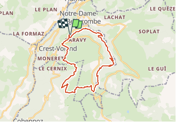
Ruta Senderismo de 16,2 km a descubrir en Auvergne-Rhône-Alpes, Saboya, Crest-Voland. Esta ruta ha sido propuesta por elcanario.
Descripción
belle randonnée très variée. Première partie facile, deuxième plus sportif. pas toujours facile de trouver le chemin. parfois sentier étroit sur pente raide
Localización
País:
France
Región :
Auvergne-Rhône-Alpes
Departamento/provincia :
Saboya
Municipio :
Crest-Voland
Localidad:
Unknown
Salida:(Dec)
Salida:(UTM)
306599 ; 5074781 (32T) N.
Comentarios
Excursiones cerca
![Excursión Senderismo Hauteluce - sous Bisanne au lac des Saisies - Photo](https://media.geolcdn.com/t/375/260/37326f22-0206-4f0e-b1e9-16790c9e91ab.jpg&format=jpg&maxdim=2)
![Senderismo Senderismo](https://static1.geolcdn.com/sitytour/trail-icons/101.png)
sous Bisanne au lac des Saisies
Senderismo
Medio
(1)
Hauteluce,
Auvergne-Rhône-Alpes,
Saboya,
France
![](/images/other/stat-length.png)
18,1 km | 28 km-effort
5h 36min
![](https://static1.geolcdn.com/siteimages/upload/files/16400158638029165_repeat_loop_refresh_sync_direction_icon.png)
Sí
![Excursión Senderismo Praz-sur-Arly - Balade dans le Val d'Arly - Le Crêt du Midi - Photo](https://media.geolcdn.com/t/375/260/ext.jpg?maxdim=2&url=https%3A%2F%2Fservices.sitytrail.com%2FGeolivesWS%2FDownloadMedia.ashx%3FTrailID%3D108784%26Media%3D1951_2.jpg)
![Senderismo Senderismo](https://static1.geolcdn.com/sitytour/trail-icons/101.png)
Balade dans le Val d'Arly - Le Crêt du Midi
Senderismo
Difícil
(2)
Praz-sur-Arly,
Auvergne-Rhône-Alpes,
Alta Saboya,
France
![](/images/other/stat-length.png)
11,2 km | 21 km-effort
5h 0min
![](https://static1.geolcdn.com/siteimages/upload/files/16400158638029165_repeat_loop_refresh_sync_direction_icon.png)
Sí
![Excursión Senderismo Cohennoz - suuntoapp-Hiking-2024-09-12T06-49-26Z - Photo](https://media.geolcdn.com/t/375/260/5a9a46b9-fe4c-4381-acb4-fc88d25b8d08.jpg&format=jpg&maxdim=2)
![Senderismo Senderismo](https://static1.geolcdn.com/sitytour/trail-icons/101.png)
suuntoapp-Hiking-2024-09-12T06-49-26Z
Senderismo
Muy difícil
Cohennoz,
Auvergne-Rhône-Alpes,
Saboya,
France
![](/images/other/stat-length.png)
22 km | 37 km-effort
8h 21min
![](https://static1.geolcdn.com/siteimages/upload/files/16400158638029165_repeat_loop_refresh_sync_direction_icon.png)
No
![Excursión Esquí de fondo Praz-sur-Arly - Tête du Torraz - Photo](https://media.geolcdn.com/t/375/260/24f78c03-38ed-430b-939f-d7ada4ba5583.jpg&format=jpg&maxdim=2)
![Esquí de fondo Esquí de fondo](https://static1.geolcdn.com/sitytour/trail-icons/503.png)
Tête du Torraz
Esquí de fondo
Fácil
Praz-sur-Arly,
Auvergne-Rhône-Alpes,
Alta Saboya,
France
![](/images/other/stat-length.png)
12,8 km | 25 km-effort
4h 36min
![](https://static1.geolcdn.com/siteimages/upload/files/16400158638029165_repeat_loop_refresh_sync_direction_icon.png)
Sí
![Excursión Senderismo Notre-Dame-de-Bellecombe - NOTRE DAME DE BELLECOMBE - Photo](https://media.geolcdn.com/t/375/260/ext.jpg?maxdim=2&url=https%3A%2F%2Fstatic1.geolcdn.com%2Fsiteimages%2Fupload%2Ffiles%2F1553511878bg_sport_marche.png)
![Senderismo Senderismo](https://static1.geolcdn.com/sitytour/trail-icons/101.png)
NOTRE DAME DE BELLECOMBE
Senderismo
Muy fácil
(3)
Notre-Dame-de-Bellecombe,
Auvergne-Rhône-Alpes,
Saboya,
France
![](/images/other/stat-length.png)
13,3 km | 23 km-effort
5h 15min
![](https://static1.geolcdn.com/siteimages/upload/files/16400158638029165_repeat_loop_refresh_sync_direction_icon.png)
Sí
![Excursión Senderismo Saint-Nicolas-la-Chapelle - Saint Nicolas la Chapelle - Photo](https://media.geolcdn.com/t/375/260/ext.jpg?maxdim=2&url=https%3A%2F%2Fstatic1.geolcdn.com%2Fsiteimages%2Fupload%2Ffiles%2F1553511878bg_sport_marche.png)
![Senderismo Senderismo](https://static1.geolcdn.com/sitytour/trail-icons/101.png)
Saint Nicolas la Chapelle
Senderismo
Muy fácil
(1)
Saint-Nicolas-la-Chapelle,
Auvergne-Rhône-Alpes,
Saboya,
France
![](/images/other/stat-length.png)
9,3 km | 18,2 km-effort
4h 3min
![](https://static1.geolcdn.com/siteimages/upload/files/16400158638029165_repeat_loop_refresh_sync_direction_icon.png)
Sí
![Excursión Senderismo Saint-Nicolas-la-Chapelle - SAINT NICOLAS LA CHAPELLE - Photo](https://media.geolcdn.com/t/375/260/ext.jpg?maxdim=2&url=https%3A%2F%2Fstatic1.geolcdn.com%2Fsiteimages%2Fupload%2Ffiles%2F1553511878bg_sport_marche.png)
![Senderismo Senderismo](https://static1.geolcdn.com/sitytour/trail-icons/101.png)
SAINT NICOLAS LA CHAPELLE
Senderismo
Muy fácil
(1)
Saint-Nicolas-la-Chapelle,
Auvergne-Rhône-Alpes,
Saboya,
France
![](/images/other/stat-length.png)
9,5 km | 16,8 km-effort
3h 41min
![](https://static1.geolcdn.com/siteimages/upload/files/16400158638029165_repeat_loop_refresh_sync_direction_icon.png)
No
![Excursión Senderismo Hauteluce - Mont Clocher - Photo](https://media.geolcdn.com/t/375/260/ext.jpg?maxdim=2&url=https%3A%2F%2Fservices.sitytrail.com%2FGeolivesWS%2FDownloadMedia.ashx%3FTrailID%3D85242%26Media%3D20110903163145.jpg)
![Senderismo Senderismo](https://static1.geolcdn.com/sitytour/trail-icons/101.png)
Mont Clocher
Senderismo
Muy fácil
(2)
Hauteluce,
Auvergne-Rhône-Alpes,
Saboya,
France
![](/images/other/stat-length.png)
7,3 km | 10,4 km-effort
1h 47min
![](https://static1.geolcdn.com/siteimages/upload/files/16400158638029165_repeat_loop_refresh_sync_direction_icon.png)
Sí
![Excursión Senderismo Praz-sur-Arly - Torraz christomet 928m 18kms - Photo](https://media.geolcdn.com/t/375/260/db8f3a68-df77-4178-9be5-63f69fcee281.jpg&format=jpg&maxdim=2)
![Senderismo Senderismo](https://static1.geolcdn.com/sitytour/trail-icons/101.png)
Torraz christomet 928m 18kms
Senderismo
Medio
Praz-sur-Arly,
Auvergne-Rhône-Alpes,
Alta Saboya,
France
![](/images/other/stat-length.png)
16,2 km | 29 km-effort
7h 13min
![](https://static1.geolcdn.com/siteimages/upload/files/16400158638029165_repeat_loop_refresh_sync_direction_icon.png)
No