![](/images/other/stat-length.png)
Vallon Aiguilles d'Arves et col de Petit Jean
ranchoup
Usuario
![Longitud](/images/other/stat-length.png)
![Altitud máxima](https://static1.geolcdn.com/siteimages/upload/files/1508320355ic_sort_altitude_max_24dp.png)
![Desnivel positivo](https://static1.geolcdn.com/siteimages/upload/files/1508320355ic_sort_den_pos_24dp.png)
![Km-Effort](/images/other/stat-length.png)
![Altitud mínima](https://static1.geolcdn.com/siteimages/upload/files/1508320355ic_sort_altitude_min_24dp.png)
![Desnivel negativo](https://static1.geolcdn.com/siteimages/upload/files/1508320355ic_sort_den_neg_24dp.png)
![Boucle](https://static1.geolcdn.com/siteimages/upload/files/16400158638029165_repeat_loop_refresh_sync_direction_icon.png)
![Senderismo](https://static1.geolcdn.com/sitytour/trail-icons/101.png)
9h00
Dificultad : Difícil
![Escanee este código QR para abrir la excursión en la aplicación SityTrail](https://capi.geolives.com/qq0zvz2zws4bq2lad0pu/sitytour/trails/2536858/qr.png?size=200)
Aplicación GPS de excursión GRATIS
A propósito
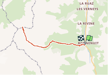
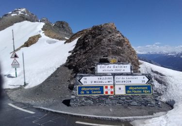
Ruta Senderismo de 15,7 km a descubrir en Auvergne-Rhône-Alpes, Saboya, Valloire. Esta ruta ha sido propuesta por ranchoup.
Descripción
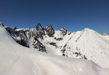
Départ parking hameau de Bonnenuit au dessus de Valloire.
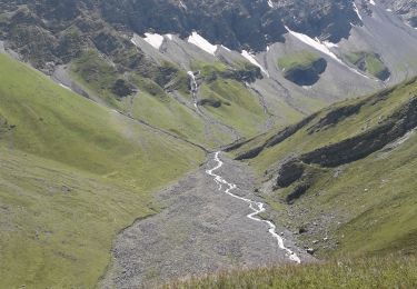
Très belle montée bien tracée jusqu'au fond du vallon en passant par le refuge des Aiguilles d'Arves. Attention le sentier est érodé en dévers sur plusieurs tronçons aprrès le refuge vers le fond du vallon.
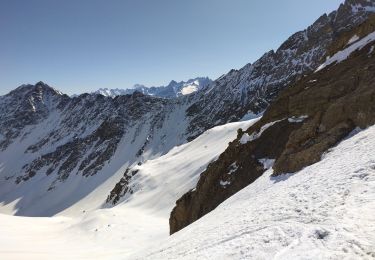
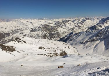
Puis montée raide et un peu aérienne et difficile dans les éboulis pour atteindre le col de Petit Jean (3065). Péférer la montée sur la partie gauche (gros éboulis) et la redescente dans la partie éboulis fins ; batons recommandés. Très belle vue au col en ce début septembre 2020. Compter 5h de montée et 3h30 de descente.
Localización
Comentarios
Excursiones cerca
![Excursión Senderismo Valloire - Le Pic de l'Aigle (ou presque), 2776m - Photo](https://media.geolcdn.com/t/375/260/ext.jpg?maxdim=2&url=https%3A%2F%2Fservices.sitytrail.com%2FGeolivesWS%2FDownloadMedia.ashx%3FTrailID%3D107289%26Media%3D12175_1.jpg)
![Senderismo Senderismo](https://static1.geolcdn.com/sitytour/trail-icons/101.png)
Senderismo
![](/images/other/stat-length.png)
![](https://static1.geolcdn.com/siteimages/upload/files/16400158638029165_repeat_loop_refresh_sync_direction_icon.png)
![Excursión Senderismo Valloire - GPX Download: Boucle Vue sur le lac de Cerces – Lac des Cerces au départ de Moulin Benjamin - Photo](https://media.geolcdn.com/t/375/260/ext.jpg?maxdim=2&url=https%3A%2F%2Fstatic1.geolcdn.com%2Fsiteimages%2Fupload%2Ffiles%2F1553511878bg_sport_marche.png)
![Senderismo Senderismo](https://static1.geolcdn.com/sitytour/trail-icons/101.png)
Senderismo
![](/images/other/stat-length.png)
![](https://static1.geolcdn.com/siteimages/upload/files/16400158638029165_repeat_loop_refresh_sync_direction_icon.png)
![Excursión Esquí de fondo Valloire - Tricotage pic blanc du Galibier, petit Galibier ouest.. - Photo](https://media.geolcdn.com/t/375/260/5fb80036-d061-47ea-be50-06ae2f510eef.jpg&format=jpg&maxdim=2)
![Esquí de fondo Esquí de fondo](https://static1.geolcdn.com/sitytour/trail-icons/503.png)
Esquí de fondo
![](/images/other/stat-length.png)
![](https://static1.geolcdn.com/siteimages/upload/files/16400158638029165_repeat_loop_refresh_sync_direction_icon.png)
![Excursión Senderismo Valloire - le grand Galibier par le plan lachat - Photo](https://media.geolcdn.com/t/375/260/ext.jpg?maxdim=2&url=https%3A%2F%2Fservices.sitytrail.com%2FGeolivesWS%2FDownloadMedia.ashx%3FTrailID%3D464698%26Media%3D82d2ca84-ebcc-4d20-9f14-0e6afb40d51f.JPG)
![Senderismo Senderismo](https://static1.geolcdn.com/sitytour/trail-icons/101.png)
Senderismo
![](/images/other/stat-length.png)
![](https://static1.geolcdn.com/siteimages/upload/files/16400158638029165_repeat_loop_refresh_sync_direction_icon.png)
![Excursión Esquí de fondo Valloire - PT 2973 sur la crête d'argentière - Photo](https://media.geolcdn.com/t/375/260/9dd54d7b-14b1-43db-b5e7-f165732d35b0.jpg&format=jpg&maxdim=2)
![Esquí de fondo Esquí de fondo](https://static1.geolcdn.com/sitytour/trail-icons/503.png)
Esquí de fondo
![](/images/other/stat-length.png)
![](https://static1.geolcdn.com/siteimages/upload/files/16400158638029165_repeat_loop_refresh_sync_direction_icon.png)
![Excursión Esquí de fondo Valloire - Col de petit Jean - Photo](https://media.geolcdn.com/t/375/260/e1f50793-9675-4ea6-9a1c-3ba4e20102bf.jpg&format=jpg&maxdim=2)
![Esquí de fondo Esquí de fondo](https://static1.geolcdn.com/sitytour/trail-icons/503.png)
Esquí de fondo
![](/images/other/stat-length.png)
![](https://static1.geolcdn.com/siteimages/upload/files/16400158638029165_repeat_loop_refresh_sync_direction_icon.png)
![Excursión Esquí de fondo Valloire - Aiguille de l'épaisseur - Photo](https://media.geolcdn.com/t/375/260/77d61587-180b-4205-b36d-a83a35e6850c.jpg&format=jpg&maxdim=2)
![Esquí de fondo Esquí de fondo](https://static1.geolcdn.com/sitytour/trail-icons/503.png)
Esquí de fondo
![](/images/other/stat-length.png)
![](https://static1.geolcdn.com/siteimages/upload/files/16400158638029165_repeat_loop_refresh_sync_direction_icon.png)
![Excursión Senderismo Valloire - Bonne nuit- refuge - combe des Aiguilles - Photo](https://media.geolcdn.com/t/375/260/324355e1-ed1e-44dd-bc99-5afcf7d1c974.jpg&format=jpg&maxdim=2)
![Senderismo Senderismo](https://static1.geolcdn.com/sitytour/trail-icons/101.png)
Senderismo
![](/images/other/stat-length.png)
![](https://static1.geolcdn.com/siteimages/upload/files/16400158638029165_repeat_loop_refresh_sync_direction_icon.png)
![Excursión Esquí de fondo Valloire - le petit Galibier et le Pic blanc du Galibier - Photo](https://media.geolcdn.com/t/375/260/13e5b259-248b-4414-b2ce-a9ffa155710d.jpg&format=jpg&maxdim=2)
![Esquí de fondo Esquí de fondo](https://static1.geolcdn.com/sitytour/trail-icons/503.png)
Esquí de fondo
![](/images/other/stat-length.png)
![](https://static1.geolcdn.com/siteimages/upload/files/16400158638029165_repeat_loop_refresh_sync_direction_icon.png)