![](/images/other/stat-length.png)
![Excursión Senderismo Marigny - Lac de Chalain Marigny 1 sept 2020 CAF - Photo](https://media.geolcdn.com/t/1900/400/6d4cd6ca-3f43-44a7-a9ee-3e22d4a910fa.jpg&format=pjpeg&maxdim=2)
Lac de Chalain Marigny 1 sept 2020 CAF
TRIMAILLE
Usuario
![Longitud](/images/other/stat-length.png)
![Altitud máxima](https://static1.geolcdn.com/siteimages/upload/files/1508320355ic_sort_altitude_max_24dp.png)
![Desnivel positivo](https://static1.geolcdn.com/siteimages/upload/files/1508320355ic_sort_den_pos_24dp.png)
![Km-Effort](/images/other/stat-length.png)
![Altitud mínima](https://static1.geolcdn.com/siteimages/upload/files/1508320355ic_sort_altitude_min_24dp.png)
![Desnivel negativo](https://static1.geolcdn.com/siteimages/upload/files/1508320355ic_sort_den_neg_24dp.png)
![Boucle](https://static1.geolcdn.com/siteimages/upload/files/16400158638029165_repeat_loop_refresh_sync_direction_icon.png)
![Senderismo](https://static1.geolcdn.com/sitytour/trail-icons/101.png)
4h29
Dificultad : Muy fácil
![Escanee este código QR para abrir la excursión en la aplicación SityTrail](https://capi.geolives.com/qq0zvz2zws4bq2lad0pu/sitytour/trails/2535237/qr.png?size=200)
Aplicación GPS de excursión GRATIS
A propósito
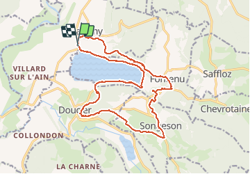
Ruta Senderismo de 19,9 km a descubrir en Borgoña-Franco Condado, Jura, Marigny. Esta ruta ha sido propuesta por TRIMAILLE.
Descripción
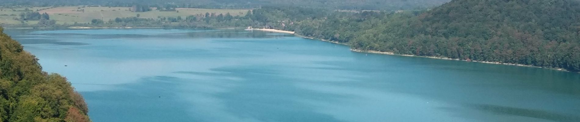
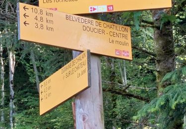
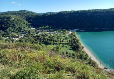
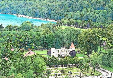
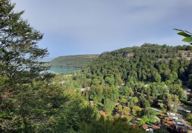
Départ du parking du camping de la Pergola. Agréable rando en bordure du lac et en hauteur. Au Km3,66 le sentier qui descend au lac est fermé en raison de glissements de terrain.
Entre le Km 12, et jusqu'au Km12,5 le sentier n'est pas évident à trouver, d'autant qu'il traverse un lapiaz.
Localización
Comentarios
Excursiones cerca
![Excursión Bici de montaña Doucier - La Dame Blanche - Doucier - Photo](https://media.geolcdn.com/t/375/260/ext.jpg?maxdim=2&url=https%3A%2F%2Fservices.sitytrail.com%2FGeolivesWS%2FDownloadMedia.ashx%3FTrailID%3D104084%26Media%3D7109_1.jpg)
![Bici de montaña Bici de montaña](https://static1.geolcdn.com/sitytour/trail-icons/202.png)
Bici de montaña
![](/images/other/stat-length.png)
![](https://static1.geolcdn.com/siteimages/upload/files/16400158638029165_repeat_loop_refresh_sync_direction_icon.png)
![Excursión Senderismo Hauteroche - Mirebel avec Taïga - Photo](https://media.geolcdn.com/t/375/260/7abbcb78-a054-422a-acee-9b73230c2c5b.jpg&format=jpg&maxdim=2)
![Senderismo Senderismo](https://static1.geolcdn.com/sitytour/trail-icons/101.png)
Senderismo
![](/images/other/stat-length.png)
![](https://static1.geolcdn.com/siteimages/upload/files/16400158638029165_repeat_loop_refresh_sync_direction_icon.png)
![Excursión Senderismo Doucier - Balisage Lac de Chambly - Photo](https://media.geolcdn.com/t/375/260/a66299b1-acba-4c28-b135-ec0a9e2beef8.jpg&format=jpg&maxdim=2)
![Senderismo Senderismo](https://static1.geolcdn.com/sitytour/trail-icons/101.png)
Senderismo
![](/images/other/stat-length.png)
![](https://static1.geolcdn.com/siteimages/upload/files/16400158638029165_repeat_loop_refresh_sync_direction_icon.png)
![Excursión Senderismo Fontenu - Tour du lac de Chalain - Photo](https://media.geolcdn.com/t/375/260/1c5595f4-5d36-4f85-b728-7ff9b046c0c9.jpg&format=jpg&maxdim=2)
![Senderismo Senderismo](https://static1.geolcdn.com/sitytour/trail-icons/101.png)
Senderismo
![](/images/other/stat-length.png)
![](https://static1.geolcdn.com/siteimages/upload/files/16400158638029165_repeat_loop_refresh_sync_direction_icon.png)
![Excursión A pie Marigny - La Queille - Photo](https://media.geolcdn.com/t/375/260/2900c982-6017-4412-a9fc-672092055637.jpeg&format=jpg&maxdim=2)
![A pie A pie](https://static1.geolcdn.com/sitytour/trail-icons/100.png)
A pie
![](/images/other/stat-length.png)
![](https://static1.geolcdn.com/siteimages/upload/files/16400158638029165_repeat_loop_refresh_sync_direction_icon.png)
![Excursión A pie Fontenu - Tour du Lac - Photo](https://media.geolcdn.com/t/375/260/2900c982-6017-4412-a9fc-672092055637.jpeg&format=jpg&maxdim=2)
![A pie A pie](https://static1.geolcdn.com/sitytour/trail-icons/100.png)
A pie
![](/images/other/stat-length.png)
![](https://static1.geolcdn.com/siteimages/upload/files/16400158638029165_repeat_loop_refresh_sync_direction_icon.png)
![Excursión Senderismo Fontenu - GR_559_AC_03_Fontenu_Bonlieu_20210914 - Photo](https://media.geolcdn.com/t/375/260/626a9953-b37f-463e-a917-966facbebecd.jpg&format=jpg&maxdim=2)
![Senderismo Senderismo](https://static1.geolcdn.com/sitytour/trail-icons/101.png)
Senderismo
![](/images/other/stat-length.png)
![](https://static1.geolcdn.com/siteimages/upload/files/16400158638029165_repeat_loop_refresh_sync_direction_icon.png)
![Excursión Senderismo Doucier - Le Moulin du Hérisson - Doucier le long du lac Chambly - Photo](https://media.geolcdn.com/t/375/260/03f03b77-53ca-444e-978f-554f51f0468c.jpg&format=jpg&maxdim=2)
![Senderismo Senderismo](https://static1.geolcdn.com/sitytour/trail-icons/101.png)
Senderismo
![](/images/other/stat-length.png)
![](https://static1.geolcdn.com/siteimages/upload/files/16400158638029165_repeat_loop_refresh_sync_direction_icon.png)
![Excursión Senderismo Doucier - Doucier tour du village - Photo](https://media.geolcdn.com/t/375/260/7bd9f5d4-11e4-4292-8bd6-74a4e0115bc8.jpg&format=jpg&maxdim=2)
![Senderismo Senderismo](https://static1.geolcdn.com/sitytour/trail-icons/101.png)
Senderismo
![](/images/other/stat-length.png)
![](https://static1.geolcdn.com/siteimages/upload/files/16400158638029165_repeat_loop_refresh_sync_direction_icon.png)