![](/images/other/stat-length.png)
![Excursión Senderismo La Garde-Freinet - Route des crêtes - La Garde-Freinet - Photo](https://media.geolcdn.com/t/1900/400/d2d34c83-0d7b-4d7d-a492-1825522e03a7.jpg&format=pjpeg&maxdim=2)
Route des crêtes - La Garde-Freinet
LBarel
Usuario
![Longitud](/images/other/stat-length.png)
![Altitud máxima](https://static1.geolcdn.com/siteimages/upload/files/1508320355ic_sort_altitude_max_24dp.png)
![Desnivel positivo](https://static1.geolcdn.com/siteimages/upload/files/1508320355ic_sort_den_pos_24dp.png)
![Km-Effort](/images/other/stat-length.png)
![Altitud mínima](https://static1.geolcdn.com/siteimages/upload/files/1508320355ic_sort_altitude_min_24dp.png)
![Desnivel negativo](https://static1.geolcdn.com/siteimages/upload/files/1508320355ic_sort_den_neg_24dp.png)
![Boucle](https://static1.geolcdn.com/siteimages/upload/files/16400158638029165_repeat_loop_refresh_sync_direction_icon.png)
![Senderismo](https://static1.geolcdn.com/sitytour/trail-icons/101.png)
2h35
Dificultad : Muy fácil
![Escanee este código QR para abrir la excursión en la aplicación SityTrail](https://capi.geolives.com/qq0zvz2zws4bq2lad0pu/sitytour/trails/2534710/qr.png?size=200)
Aplicación GPS de excursión GRATIS
A propósito
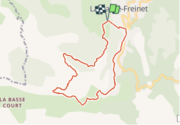
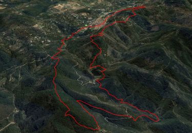
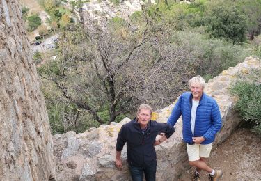
Ruta Senderismo de 9,5 km a descubrir en Provenza-Alpes-Costa Azul, Var, La Garde-Freinet. Esta ruta ha sido propuesta por LBarel.
Descripción
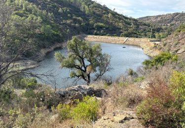
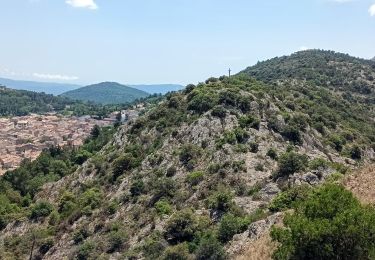
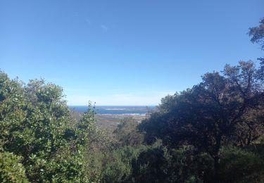
Au départ du parking de la Croix, cette balade facile emprunte la route des Crêtes. Vue sur la plaine des Maures et traversée d'une belle châtaigneraie.
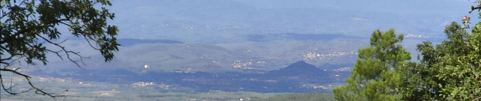
La deuxième partie remonte vers le GR9 et donne à voir les lac des Escarcets et le Luc/Le Cannet des Maures au loin. Enfin la 3e suit le GR9, petite route sinueuse jusqu'à la Garde-Freinet avec une vue imprenable sur le golfe de Saint-Tropez.
Localización
Comentarios
Excursiones cerca
![Excursión Senderismo La Garde-Freinet - SityTrail - Fort Freinet-la Garde-Freinet-02-06-23 - Photo](https://media.geolcdn.com/t/375/260/ce777452-e991-4230-8a3a-fe54e13fa23c.jpg&format=jpg&maxdim=2)
![Senderismo Senderismo](https://static1.geolcdn.com/sitytour/trail-icons/101.png)
Senderismo
![](/images/other/stat-length.png)
![](https://static1.geolcdn.com/siteimages/upload/files/16400158638029165_repeat_loop_refresh_sync_direction_icon.png)
![Excursión Senderismo Le Cannet-des-Maures - lac des escarcets - Photo](https://media.geolcdn.com/t/375/260/ext.jpg?maxdim=2&url=https%3A%2F%2Fstatic1.geolcdn.com%2Fsiteimages%2Fupload%2Ffiles%2F1553511878bg_sport_marche.png)
![Senderismo Senderismo](https://static1.geolcdn.com/sitytour/trail-icons/101.png)
Senderismo
![](/images/other/stat-length.png)
![](https://static1.geolcdn.com/siteimages/upload/files/16400158638029165_repeat_loop_refresh_sync_direction_icon.png)
![Excursión Senderismo La Garde-Freinet - La Mourre, La Garde-Freinet-22-05-24 - Photo](https://media.geolcdn.com/t/375/260/d83ec998-34f1-4f9a-9ad9-3f2fca5f6ed5.jpg&format=jpg&maxdim=2)
![Senderismo Senderismo](https://static1.geolcdn.com/sitytour/trail-icons/101.png)
Senderismo
![](/images/other/stat-length.png)
![](https://static1.geolcdn.com/siteimages/upload/files/16400158638029165_repeat_loop_refresh_sync_direction_icon.png)
![Excursión Senderismo La Garde-Freinet - Garde freinet rev - Photo](https://media.geolcdn.com/t/375/260/7c0f54ba-5dae-4e90-b68b-91a753a14687.jpg&format=jpg&maxdim=2)
![Senderismo Senderismo](https://static1.geolcdn.com/sitytour/trail-icons/101.png)
Senderismo
![](/images/other/stat-length.png)
![](https://static1.geolcdn.com/siteimages/upload/files/16400158638029165_repeat_loop_refresh_sync_direction_icon.png)
![Excursión A pie La Garde-Freinet - Fort Freinet-la Garde-Freinet-02-06-23 - Photo](https://media.geolcdn.com/t/375/260/a55d6a88-f340-481f-bdaf-db37fcbe61e6.jpg&format=jpg&maxdim=2)
![A pie A pie](https://static1.geolcdn.com/sitytour/trail-icons/100.png)
A pie
![](/images/other/stat-length.png)
![](https://static1.geolcdn.com/siteimages/upload/files/16400158638029165_repeat_loop_refresh_sync_direction_icon.png)
![Excursión Senderismo Grimaud - Grimaud - le pont des fées - Mont Roux 11.3.23 - Photo](https://media.geolcdn.com/t/375/260/b931d4cf-3c48-45c3-9286-94f622997895.jpg&format=jpg&maxdim=2)
![Senderismo Senderismo](https://static1.geolcdn.com/sitytour/trail-icons/101.png)
Senderismo
![](/images/other/stat-length.png)
![](https://static1.geolcdn.com/siteimages/upload/files/16400158638029165_repeat_loop_refresh_sync_direction_icon.png)
![Excursión Senderismo La Garde-Freinet - les roches blanches - La Garde Freinet - Photo](https://media.geolcdn.com/t/375/260/f87c2506-3a8b-4a88-ba3e-49e9b5d399bc.jpg&format=jpg&maxdim=2)
![Senderismo Senderismo](https://static1.geolcdn.com/sitytour/trail-icons/101.png)
Senderismo
![](/images/other/stat-length.png)
![](https://static1.geolcdn.com/siteimages/upload/files/16400158638029165_repeat_loop_refresh_sync_direction_icon.png)
![Excursión Senderismo La Garde-Freinet - la Garde Freinet-Les Roches Blanches - Photo](https://media.geolcdn.com/t/375/260/ext.jpg?maxdim=2&url=https%3A%2F%2Fstatic1.geolcdn.com%2Fsiteimages%2Fupload%2Ffiles%2F1553511878bg_sport_marche.png)
![Senderismo Senderismo](https://static1.geolcdn.com/sitytour/trail-icons/101.png)
Senderismo
![](/images/other/stat-length.png)
![](https://static1.geolcdn.com/siteimages/upload/files/16400158638029165_repeat_loop_refresh_sync_direction_icon.png)
![Excursión Senderismo Grimaud - Grimaud - Photo](https://media.geolcdn.com/t/375/260/d7d06650-601d-401f-a80f-38d8fa73f2de.jpg&format=jpg&maxdim=2)
![Senderismo Senderismo](https://static1.geolcdn.com/sitytour/trail-icons/101.png)
Senderismo
![](/images/other/stat-length.png)
![](https://static1.geolcdn.com/siteimages/upload/files/16400158638029165_repeat_loop_refresh_sync_direction_icon.png)