![](/images/other/stat-length.png)
Olliergues_Chabasse
jagarnier
Usuario GUIDE
![Longitud](/images/other/stat-length.png)
![Altitud máxima](https://static1.geolcdn.com/siteimages/upload/files/1508320355ic_sort_altitude_max_24dp.png)
![Desnivel positivo](https://static1.geolcdn.com/siteimages/upload/files/1508320355ic_sort_den_pos_24dp.png)
![Km-Effort](/images/other/stat-length.png)
![Altitud mínima](https://static1.geolcdn.com/siteimages/upload/files/1508320355ic_sort_altitude_min_24dp.png)
![Desnivel negativo](https://static1.geolcdn.com/siteimages/upload/files/1508320355ic_sort_den_neg_24dp.png)
![Boucle](https://static1.geolcdn.com/siteimages/upload/files/16400158638029165_repeat_loop_refresh_sync_direction_icon.png)
![Senderismo](https://static1.geolcdn.com/sitytour/trail-icons/101.png)
4h13
Dificultad : Medio
![Escanee este código QR para abrir la excursión en la aplicación SityTrail](https://capi.geolives.com/qq0zvz2zws4bq2lad0pu/sitytour/trails/2528375/qr.png?size=200)
Aplicación GPS de excursión GRATIS
A propósito
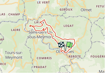
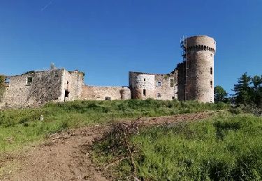
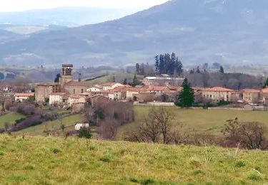
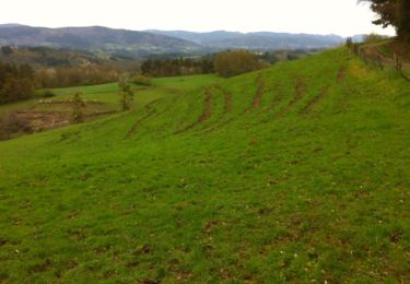
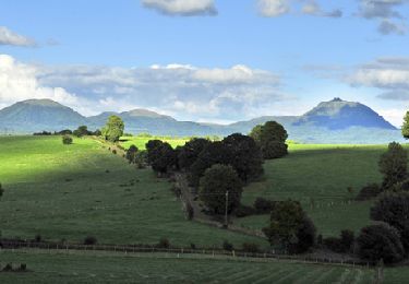
Ruta Senderismo de 13,9 km a descubrir en Auvergne-Rhône-Alpes, Puy-de-Dôme, Olliergues. Esta ruta ha sido propuesta por jagarnier.
Descripción
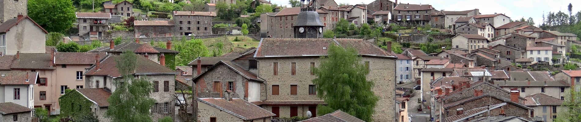
Tour d'escalier sur rue et encorbellement à pans de bois côté bourg, sobres domaines agricoles côté campagne, les demeures renaissance d'Oliergues contrastent avec la simplicité du bâti rural.
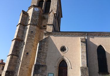
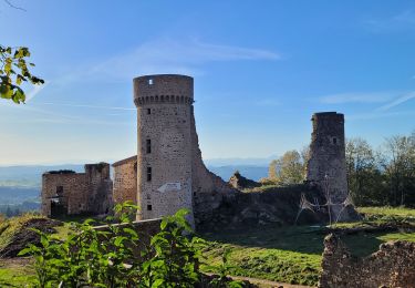
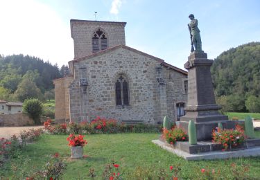
Quatre églises jalonnent cette randonnée en surplomb des gorges de la Dore.
Localización
Comentarios
Excursiones cerca
![Excursión A pie Marat - Le Communal de Rucheix - Photo](https://media.geolcdn.com/t/375/260/1e257f52-82b8-49c1-82e6-80dcbc6e086c.jpeg&format=jpg&maxdim=2)
![A pie A pie](https://static1.geolcdn.com/sitytour/trail-icons/100.png)
A pie
![](/images/other/stat-length.png)
![](https://static1.geolcdn.com/siteimages/upload/files/16400158638029165_repeat_loop_refresh_sync_direction_icon.png)
![Excursión Senderismo Olmet - Olmet_Chateau_Faye_ADV - Photo](https://media.geolcdn.com/t/375/260/03bd1c7f-f33d-4567-a966-aad40435fd04.jpg&format=jpg&maxdim=2)
![Senderismo Senderismo](https://static1.geolcdn.com/sitytour/trail-icons/101.png)
Senderismo
![](/images/other/stat-length.png)
![](https://static1.geolcdn.com/siteimages/upload/files/16400158638029165_repeat_loop_refresh_sync_direction_icon.png)
![Excursión Senderismo Olmet - Olmet_Chateau-de-la-Faye_T - Photo](https://media.geolcdn.com/t/375/260/e0d34068-bfd4-4ac8-8903-92f7c0b63772.jpg&format=jpg&maxdim=2)
![Senderismo Senderismo](https://static1.geolcdn.com/sitytour/trail-icons/101.png)
Senderismo
![](/images/other/stat-length.png)
![](https://static1.geolcdn.com/siteimages/upload/files/16400158638029165_repeat_loop_refresh_sync_direction_icon.png)
![Excursión A pie Saint-Gervais-sous-Meymont - Autour de la Maison du Parc - Photo](https://media.geolcdn.com/t/375/260/0cb21de0-a948-4a11-a8b1-73f69021aafa.jpeg&format=jpg&maxdim=2)
![A pie A pie](https://static1.geolcdn.com/sitytour/trail-icons/100.png)
A pie
![](/images/other/stat-length.png)
![](https://static1.geolcdn.com/siteimages/upload/files/16400158638029165_repeat_loop_refresh_sync_direction_icon.png)
![Excursión Senderismo Olmet - Olmet_Ruisseaux - Photo](https://media.geolcdn.com/t/375/260/0878d6d3-1e6c-43cb-9e8e-366251fbcb27.jpg&format=jpg&maxdim=2)
![Senderismo Senderismo](https://static1.geolcdn.com/sitytour/trail-icons/101.png)
Senderismo
![](/images/other/stat-length.png)
![](https://static1.geolcdn.com/siteimages/upload/files/16400158638029165_repeat_loop_refresh_sync_direction_icon.png)
![Excursión Senderismo Tours-sur-Meymont - Tours_Meymont_Gorges_Dore - Photo](https://media.geolcdn.com/t/375/260/63fd52ef-9088-4caf-ab22-5e5d95806189.jpg&format=jpg&maxdim=2)
![Senderismo Senderismo](https://static1.geolcdn.com/sitytour/trail-icons/101.png)
Senderismo
![](/images/other/stat-length.png)
![](https://static1.geolcdn.com/siteimages/upload/files/16400158638029165_repeat_loop_refresh_sync_direction_icon.png)
![Excursión Senderismo Tours-sur-Meymont - De Tours sur Meymont au Moulin du Garret - Photo](https://media.geolcdn.com/t/375/260/ext.jpg?maxdim=2&url=https%3A%2F%2Fservices.sitytrail.com%2FGeolivesWS%2FDownloadMedia.ashx%3FTrailID%3D129777%26Media%3D13320_3.jpg)
![Senderismo Senderismo](https://static1.geolcdn.com/sitytour/trail-icons/101.png)
Senderismo
![](/images/other/stat-length.png)
![](https://static1.geolcdn.com/siteimages/upload/files/16400158638029165_repeat_loop_refresh_sync_direction_icon.png)
![Excursión Senderismo La Chapelle-Agnon - Chapelle_Agnon_Pierre_Blanche - Photo](https://media.geolcdn.com/t/375/260/bf721f45-2b95-48ec-8a90-f0651334b4b8.jpg&format=jpg&maxdim=2)
![Senderismo Senderismo](https://static1.geolcdn.com/sitytour/trail-icons/101.png)
Senderismo
![](/images/other/stat-length.png)
![](https://static1.geolcdn.com/siteimages/upload/files/16400158638029165_repeat_loop_refresh_sync_direction_icon.png)
![Excursión A pie La Chapelle-Agnon - La Chapelle-Agnon - Photo](https://media.geolcdn.com/t/375/260/ext.jpg?maxdim=2&url=https%3A%2F%2Fstatic1.geolcdn.com%2Fsiteimages%2Fupload%2Ffiles%2F1545311037marcheuse_200dpi.jpg)
![A pie A pie](https://static1.geolcdn.com/sitytour/trail-icons/100.png)
A pie
![](/images/other/stat-length.png)
![](https://static1.geolcdn.com/siteimages/upload/files/16400158638029165_repeat_loop_refresh_sync_direction_icon.png)