![](/images/other/stat-length.png)
![Excursión Senderismo Sentheim - Marcher au marché - Photo](https://media.geolcdn.com/t/1900/400/e99c9112-3f27-4041-98e8-c2e797102910.jpg&format=pjpeg&maxdim=2)
Marcher au marché
helmut68
Usuario
![Longitud](/images/other/stat-length.png)
Longitud
14,3 km
![Altitud máxima](https://static1.geolcdn.com/siteimages/upload/files/1508320355ic_sort_altitude_max_24dp.png)
Altitud máxima
536 m
![Desnivel positivo](https://static1.geolcdn.com/siteimages/upload/files/1508320355ic_sort_den_pos_24dp.png)
Desnivel positivo
302 m
![Km-Effort](/images/other/stat-length.png)
Km-Effort
18,3 km
![Altitud mínima](https://static1.geolcdn.com/siteimages/upload/files/1508320355ic_sort_altitude_min_24dp.png)
Altitud mínima
353 m
![Desnivel negativo](https://static1.geolcdn.com/siteimages/upload/files/1508320355ic_sort_den_neg_24dp.png)
Desnivel negativo
302 m
![Boucle](https://static1.geolcdn.com/siteimages/upload/files/16400158638029165_repeat_loop_refresh_sync_direction_icon.png)
Boucle
Sí
Fecha de creación :
2020-08-26 07:19:56.881
Última modificación :
2020-08-26 11:54:18.783
![Senderismo](https://static1.geolcdn.com/sitytour/trail-icons/101.png)
2h32
Dificultad : Fácil
![Escanee este código QR para abrir la excursión en la aplicación SityTrail](https://capi.geolives.com/qq0zvz2zws4bq2lad0pu/sitytour/trails/2528348/qr.png?size=200)
Aplicación GPS de excursión GRATIS
A propósito
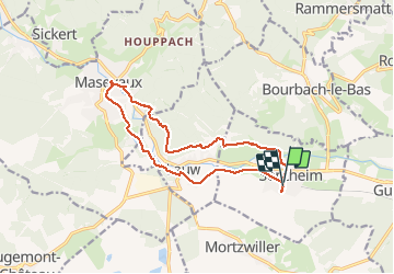
Ruta Senderismo de 14,3 km a descubrir en Gran Este, Alto Rin, Sentheim. Esta ruta ha sido propuesta por helmut68.
Descripción
Boucle principalement en forêt pour faire le marché de Masevaux ( tous les mercredis matins ) à partir de Sentheim.
Alors à vos chaussures...N'oubliez pas le porte monnaie et le masque !
Localización
País:
France
Región :
Gran Este
Departamento/provincia :
Alto Rin
Municipio :
Sentheim
Localidad:
Unknown
Salida:(Dec)
Salida:(UTM)
353923 ; 5290751 (32T) N.
Comentarios
Excursiones cerca
![Excursión Senderismo Masevaux-Niederbruck - Masevaux - Rossberg par le belvédère du Fuchsfelsen - Photo](https://media.geolcdn.com/t/375/260/d9cc765c-1250-4953-9d9f-fb8b88eb82a7.jpg&format=jpg&maxdim=2)
![Senderismo Senderismo](https://static1.geolcdn.com/sitytour/trail-icons/101.png)
Masevaux - Rossberg par le belvédère du Fuchsfelsen
Senderismo
Medio
(1)
Masevaux-Niederbruck,
Gran Este,
Alto Rin,
France
![](/images/other/stat-length.png)
19,9 km | 34 km-effort
4h 44min
![](https://static1.geolcdn.com/siteimages/upload/files/16400158638029165_repeat_loop_refresh_sync_direction_icon.png)
Sí
![Excursión Senderismo Sentheim - Sentheim Rossberg - Photo](https://media.geolcdn.com/t/375/260/a036ff16-f534-44a4-ad7d-39598edf8c1e.jpg&format=jpg&maxdim=2)
![Senderismo Senderismo](https://static1.geolcdn.com/sitytour/trail-icons/101.png)
Sentheim Rossberg
Senderismo
Medio
(1)
Sentheim,
Gran Este,
Alto Rin,
France
![](/images/other/stat-length.png)
27 km | 40 km-effort
6h 11min
![](https://static1.geolcdn.com/siteimages/upload/files/16400158638029165_repeat_loop_refresh_sync_direction_icon.png)
Sí
![Excursión Senderismo Lauw - 2022-07-14 Marche Lauw Refuge CAF Baerenkopf - Photo](https://media.geolcdn.com/t/375/260/e2209d17-65ac-46f6-a404-5274e10a843e.jpg&format=jpg&maxdim=2)
![Senderismo Senderismo](https://static1.geolcdn.com/sitytour/trail-icons/101.png)
2022-07-14 Marche Lauw Refuge CAF Baerenkopf
Senderismo
Muy difícil
Lauw,
Gran Este,
Alto Rin,
France
![](/images/other/stat-length.png)
18,4 km | 31 km-effort
5h 35min
![](https://static1.geolcdn.com/siteimages/upload/files/16400158638029165_repeat_loop_refresh_sync_direction_icon.png)
No
![Excursión A pie Sentheim - Sentier géologique du Wolfloch - Photo](https://media.geolcdn.com/t/375/260/3b31644e-e98b-4e9b-958d-a3c4208c2bbd.jpeg&format=jpg&maxdim=2)
![A pie A pie](https://static1.geolcdn.com/sitytour/trail-icons/100.png)
Sentier géologique du Wolfloch
A pie
Fácil
Sentheim,
Gran Este,
Alto Rin,
France
![](/images/other/stat-length.png)
3,8 km | 4,8 km-effort
1h 5min
![](https://static1.geolcdn.com/siteimages/upload/files/16400158638029165_repeat_loop_refresh_sync_direction_icon.png)
No
![Excursión A pie Sentheim - Sentheim - Bergwald - Eichwald - Guevenheim - Sentheim - Photo](https://media.geolcdn.com/t/375/260/ext.jpg?maxdim=2&url=https%3A%2F%2Fstatic1.geolcdn.com%2Fsiteimages%2Fupload%2Ffiles%2F1545311037marcheuse_200dpi.jpg)
![A pie A pie](https://static1.geolcdn.com/sitytour/trail-icons/100.png)
Sentheim - Bergwald - Eichwald - Guevenheim - Sentheim
A pie
Fácil
(1)
Sentheim,
Gran Este,
Alto Rin,
France
![](/images/other/stat-length.png)
13,4 km | 16,6 km-effort
Desconocido
![](https://static1.geolcdn.com/siteimages/upload/files/16400158638029165_repeat_loop_refresh_sync_direction_icon.png)
Sí
![Excursión Senderismo Masevaux-Niederbruck - Reco avec ALAIN..Rando CLAS du 29/08/2024 - Photo](https://media.geolcdn.com/t/375/260/5dba7985-af1b-4076-a275-05f9cb5145f8.jpg&format=jpg&maxdim=2)
![Senderismo Senderismo](https://static1.geolcdn.com/sitytour/trail-icons/101.png)
Reco avec ALAIN..Rando CLAS du 29/08/2024
Senderismo
Muy difícil
Masevaux-Niederbruck,
Gran Este,
Alto Rin,
France
![](/images/other/stat-length.png)
20 km | 31 km-effort
6h 2min
![](https://static1.geolcdn.com/siteimages/upload/files/16400158638029165_repeat_loop_refresh_sync_direction_icon.png)
Sí
![Excursión Senderismo Sentheim - Randonnée Pentecôte 2024 - Photo](https://media.geolcdn.com/t/375/260/5b01bebc-5c9b-4fee-93d4-97171ac59809.jpg&format=jpg&maxdim=2)
![Senderismo Senderismo](https://static1.geolcdn.com/sitytour/trail-icons/101.png)
Randonnée Pentecôte 2024
Senderismo
Medio
Sentheim,
Gran Este,
Alto Rin,
France
![](/images/other/stat-length.png)
14,8 km | 18,3 km-effort
4h 0min
![](https://static1.geolcdn.com/siteimages/upload/files/16400158638029165_repeat_loop_refresh_sync_direction_icon.png)
Sí
![Excursión Senderismo Sentheim - Knapphutte Saegenkopf Hütte - Photo](https://media.geolcdn.com/t/375/260/40c0149e-a232-4115-bfb0-15079675190f.jpg&format=jpg&maxdim=2)
![Senderismo Senderismo](https://static1.geolcdn.com/sitytour/trail-icons/101.png)
Knapphutte Saegenkopf Hütte
Senderismo
Medio
Sentheim,
Gran Este,
Alto Rin,
France
![](/images/other/stat-length.png)
13,8 km | 17,2 km-effort
5h 11min
![](https://static1.geolcdn.com/siteimages/upload/files/16400158638029165_repeat_loop_refresh_sync_direction_icon.png)
Sí
![Excursión Senderismo Sentheim - Montori - Photo](https://media.geolcdn.com/t/375/260/60fb76bf-d069-4a22-ad34-ce9de6b50bcf.jpg&format=jpg&maxdim=2)
![Senderismo Senderismo](https://static1.geolcdn.com/sitytour/trail-icons/101.png)