![](/images/other/stat-length.png)
![Excursión A pie Saint-Jacques-des-Blats - Font de Cère-Puy Griou - Photo](https://media.geolcdn.com/t/1900/400/ext.pjpeg?maxdim=2&url=https%3A%2F%2Fstatic1.geolcdn.com%2Fsiteimages%2Fupload%2Ffiles%2F1545311037marcheuse_200dpi.jpg)
Font de Cère-Puy Griou
Gaillard Isabelle
Usuario
![Longitud](/images/other/stat-length.png)
Longitud
16,6 km
![Altitud máxima](https://static1.geolcdn.com/siteimages/upload/files/1508320355ic_sort_altitude_max_24dp.png)
Altitud máxima
1670 m
![Desnivel positivo](https://static1.geolcdn.com/siteimages/upload/files/1508320355ic_sort_den_pos_24dp.png)
Desnivel positivo
783 m
![Km-Effort](/images/other/stat-length.png)
Km-Effort
27 km
![Altitud mínima](https://static1.geolcdn.com/siteimages/upload/files/1508320355ic_sort_altitude_min_24dp.png)
Altitud mínima
1197 m
![Desnivel negativo](https://static1.geolcdn.com/siteimages/upload/files/1508320355ic_sort_den_neg_24dp.png)
Desnivel negativo
788 m
![Boucle](https://static1.geolcdn.com/siteimages/upload/files/16400158638029165_repeat_loop_refresh_sync_direction_icon.png)
Boucle
Sí
Fecha de creación :
2020-08-22 13:52:47.29
Última modificación :
2020-08-24 07:05:28.794
![A pie](https://static1.geolcdn.com/sitytour/trail-icons/100.png)
--
Dificultad : Medio
![Escanee este código QR para abrir la excursión en la aplicación SityTrail](https://capi.geolives.com/qq0zvz2zws4bq2lad0pu/sitytour/trails/2523821/qr.png?size=200)
Aplicación GPS de excursión GRATIS
A propósito
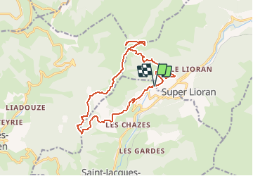
Ruta A pie de 16,6 km a descubrir en Auvergne-Rhône-Alpes, Cantal, Saint-Jacques-des-Blats. Esta ruta ha sido propuesta por Gaillard Isabelle.
Descripción
Petit problème technique, 21 Km au final pour 6H15 de marche active...Très belle randonnée
Localización
País:
France
Región :
Auvergne-Rhône-Alpes
Departamento/provincia :
Cantal
Municipio :
Saint-Jacques-des-Blats
Localidad:
Unknown
Salida:(Dec)
Salida:(UTM)
478962 ; 4992452 (31T) N.
Comentarios
Excursiones cerca
![Excursión Senderismo Albepierre-Bredons - Cantal - Col de Prat de Bouc Le Plomb du Cantal - 8.2km 450m 2h45 - 2019 07 06 - Photo](https://media.geolcdn.com/t/375/260/1b4e5d5e-f4da-4328-b35b-79db214ae669.jpg&format=jpg&maxdim=2)
![Senderismo Senderismo](https://static1.geolcdn.com/sitytour/trail-icons/101.png)
Cantal - Col de Prat de Bouc Le Plomb du Cantal - 8.2km 450m 2h45 - 2019 07 06
Senderismo
Medio
(1)
Albepierre-Bredons,
Auvergne-Rhône-Alpes,
Cantal,
France
![](/images/other/stat-length.png)
8,2 km | 14,2 km-effort
2h 45min
![](https://static1.geolcdn.com/siteimages/upload/files/16400158638029165_repeat_loop_refresh_sync_direction_icon.png)
Sí
![Excursión Senderismo Laveissière - Le Puy Griou de Super Lioran - Photo](https://media.geolcdn.com/t/375/260/ext.jpg?maxdim=2&url=https%3A%2F%2Fservices.sitytrail.com%2FGeolivesWS%2FDownloadMedia.ashx%3FTrailID%3D105565%26Media%3D9330_5.jpg)
![Senderismo Senderismo](https://static1.geolcdn.com/sitytour/trail-icons/101.png)
Le Puy Griou de Super Lioran
Senderismo
Medio
(2)
Laveissière,
Auvergne-Rhône-Alpes,
Cantal,
France
![](/images/other/stat-length.png)
11,9 km | 19,7 km-effort
5h 0min
![](https://static1.geolcdn.com/siteimages/upload/files/16400158638029165_repeat_loop_refresh_sync_direction_icon.png)
Sí
![Excursión Senderismo Laveissière - Le plomb du Cantal - Le Lioran - Photo](https://media.geolcdn.com/t/375/260/ext.jpg?maxdim=2&url=https%3A%2F%2Fservices.sitytrail.com%2FGeolivesWS%2FDownloadMedia.ashx%3FTrailID%3D105562%26Media%3D9325_5.jpg)
![Senderismo Senderismo](https://static1.geolcdn.com/sitytour/trail-icons/101.png)
Le plomb du Cantal - Le Lioran
Senderismo
Medio
(1)
Laveissière,
Auvergne-Rhône-Alpes,
Cantal,
France
![](/images/other/stat-length.png)
14,4 km | 27 km-effort
6h 0min
![](https://static1.geolcdn.com/siteimages/upload/files/16400158638029165_repeat_loop_refresh_sync_direction_icon.png)
Sí
![Excursión Senderismo Laveissière - Les crêtes du Cantal - Le Lioran - Photo](https://media.geolcdn.com/t/375/260/ext.jpg?maxdim=2&url=https%3A%2F%2Fservices.sitytrail.com%2FGeolivesWS%2FDownloadMedia.ashx%3FTrailID%3D106122%26Media%3D10357_2.jpg)
![Senderismo Senderismo](https://static1.geolcdn.com/sitytour/trail-icons/101.png)
Les crêtes du Cantal - Le Lioran
Senderismo
Difícil
(4)
Laveissière,
Auvergne-Rhône-Alpes,
Cantal,
France
![](/images/other/stat-length.png)
28 km | 51 km-effort
7h 30min
![](https://static1.geolcdn.com/siteimages/upload/files/16400158638029165_repeat_loop_refresh_sync_direction_icon.png)
Sí
![Excursión Senderismo Laveissière - le Peyre Arse - Le Lioran - Photo](https://media.geolcdn.com/t/375/260/ext.jpg?maxdim=2&url=https%3A%2F%2Fservices.sitytrail.com%2FGeolivesWS%2FDownloadMedia.ashx%3FTrailID%3D103642%26Media%3D6060_2.jpg)
![Senderismo Senderismo](https://static1.geolcdn.com/sitytour/trail-icons/101.png)
le Peyre Arse - Le Lioran
Senderismo
Difícil
(1)
Laveissière,
Auvergne-Rhône-Alpes,
Cantal,
France
![](/images/other/stat-length.png)
11,2 km | 19,4 km-effort
4h 0min
![](https://static1.geolcdn.com/siteimages/upload/files/16400158638029165_repeat_loop_refresh_sync_direction_icon.png)
No
![Excursión Senderismo Laveissière - Lioran 2023-08-18 Col de Rombière Col du Pertus A/R - Photo](https://media.geolcdn.com/t/375/260/ext.jpg?maxdim=2&url=https%3A%2F%2Fstatic1.geolcdn.com%2Fsiteimages%2Fupload%2Ffiles%2F1553511878bg_sport_marche.png)
![Senderismo Senderismo](https://static1.geolcdn.com/sitytour/trail-icons/101.png)
Lioran 2023-08-18 Col de Rombière Col du Pertus A/R
Senderismo
Fácil
(1)
Laveissière,
Auvergne-Rhône-Alpes,
Cantal,
France
![](/images/other/stat-length.png)
12,5 km | 18,8 km-effort
4h 14min
![](https://static1.geolcdn.com/siteimages/upload/files/16400158638029165_repeat_loop_refresh_sync_direction_icon.png)
Sí
![Excursión Senderismo Laveissière - Lioran 2023-08-11 Col du Pertus - Photo](https://media.geolcdn.com/t/375/260/ext.jpg?maxdim=2&url=https%3A%2F%2Fstatic1.geolcdn.com%2Fsiteimages%2Fupload%2Ffiles%2F1553511878bg_sport_marche.png)
![Senderismo Senderismo](https://static1.geolcdn.com/sitytour/trail-icons/101.png)
Lioran 2023-08-11 Col du Pertus
Senderismo
Medio
(1)
Laveissière,
Auvergne-Rhône-Alpes,
Cantal,
France
![](/images/other/stat-length.png)
17,3 km | 25 km-effort
2h 57min
![](https://static1.geolcdn.com/siteimages/upload/files/16400158638029165_repeat_loop_refresh_sync_direction_icon.png)
Sí
![Excursión Senderismo Laveissière - Lioran 2023-08-09 Puy de Seycheuse - Photo](https://media.geolcdn.com/t/375/260/ext.jpg?maxdim=2&url=https%3A%2F%2Fstatic1.geolcdn.com%2Fsiteimages%2Fupload%2Ffiles%2F1553511878bg_sport_marche.png)
![Senderismo Senderismo](https://static1.geolcdn.com/sitytour/trail-icons/101.png)
Lioran 2023-08-09 Puy de Seycheuse
Senderismo
Muy difícil
(1)
Laveissière,
Auvergne-Rhône-Alpes,
Cantal,
France
![](/images/other/stat-length.png)
13,9 km | 23 km-effort
5h 20min
![](https://static1.geolcdn.com/siteimages/upload/files/16400158638029165_repeat_loop_refresh_sync_direction_icon.png)
Sí
![Excursión Ruta Laveissière - Puy de Peyre Arse/ Puy Bataillouse / Téton de Vénus et Rocher du bec de l'aigle - Photo](https://media.geolcdn.com/t/375/260/2efbec1e-0f56-4871-abca-4b6cd09b30d9.jpg&format=jpg&maxdim=2)
![Ruta Ruta](https://static1.geolcdn.com/sitytour/trail-icons/104.png)
Puy de Peyre Arse/ Puy Bataillouse / Téton de Vénus et Rocher du bec de l'aigle
Ruta
Medio
Laveissière,
Auvergne-Rhône-Alpes,
Cantal,
France
![](/images/other/stat-length.png)
12,8 km | 25 km-effort
3h 4min
![](https://static1.geolcdn.com/siteimages/upload/files/16400158638029165_repeat_loop_refresh_sync_direction_icon.png)
Sí