![](/images/other/stat-length.png)
![Excursión Senderismo Beersel - zennebeemd - Photo](https://media.geolcdn.com/t/1900/400/ext.pjpeg?maxdim=2&url=https%3A%2F%2Fstatic1.geolcdn.com%2Fsiteimages%2Fupload%2Ffiles%2F1553511878bg_sport_marche.png)
zennebeemd
jmpierlot
Usuario
![Longitud](/images/other/stat-length.png)
Longitud
4,4 km
![Altitud máxima](https://static1.geolcdn.com/siteimages/upload/files/1508320355ic_sort_altitude_max_24dp.png)
Altitud máxima
87 m
![Desnivel positivo](https://static1.geolcdn.com/siteimages/upload/files/1508320355ic_sort_den_pos_24dp.png)
Desnivel positivo
74 m
![Km-Effort](/images/other/stat-length.png)
Km-Effort
5,4 km
![Altitud mínima](https://static1.geolcdn.com/siteimages/upload/files/1508320355ic_sort_altitude_min_24dp.png)
Altitud mínima
19 m
![Desnivel negativo](https://static1.geolcdn.com/siteimages/upload/files/1508320355ic_sort_den_neg_24dp.png)
Desnivel negativo
61 m
![Boucle](https://static1.geolcdn.com/siteimages/upload/files/16400158638029165_repeat_loop_refresh_sync_direction_icon.png)
Boucle
Sí
Fecha de creación :
2020-08-15 09:34:23.664
Última modificación :
2020-08-15 15:55:06.981
![Senderismo](https://static1.geolcdn.com/sitytour/trail-icons/101.png)
1h26
Dificultad : Muy fácil
![Escanee este código QR para abrir la excursión en la aplicación SityTrail](https://capi.geolives.com/qq0zvz2zws4bq2lad0pu/sitytour/trails/2514742/qr.png?size=200)
Aplicación GPS de excursión GRATIS
A propósito
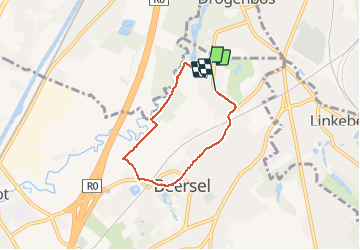
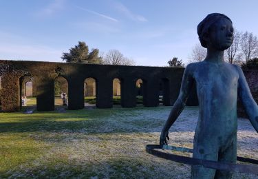
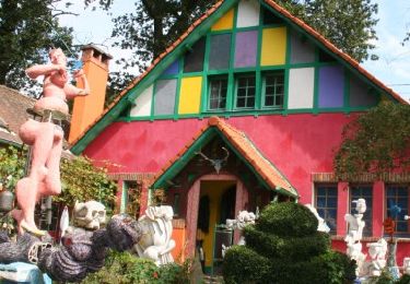
Ruta Senderismo de 4,4 km a descubrir en Flandes, Brabante Flamenco, Beersel. Esta ruta ha sido propuesta por jmpierlot.
Descripción
Une très belle balade le long de la Senne (le retour est un peu moins agréable car dans les petites rues de Beersel (où il y a par contre de nombreux restaurants, pour tous les goûts :-)
Localización
País:
Belgium
Región :
Flandes
Departamento/provincia :
Brabante Flamenco
Municipio :
Beersel
Localidad:
Beersel
Salida:(Dec)
Salida:(UTM)
592511 ; 5625932 (31U) N.
Comentarios
Excursiones cerca
![Excursión Senderismo Linkebeek - Linkebeek Perkhoeve en Peter Pan - 8 km RT - Photo](https://media.geolcdn.com/t/375/260/ext.jpg?maxdim=2&url=https%3A%2F%2Fstatic1.geolcdn.com%2Fsiteimages%2Fupload%2Ffiles%2F1553511878bg_sport_marche.png)
![Senderismo Senderismo](https://static1.geolcdn.com/sitytour/trail-icons/101.png)
Linkebeek Perkhoeve en Peter Pan - 8 km RT
Senderismo
Muy fácil
(5)
Linkebeek,
Flandes,
Brabante Flamenco,
Belgium
![](/images/other/stat-length.png)
7,6 km | 9,3 km-effort
Desconocido
![](https://static1.geolcdn.com/siteimages/upload/files/16400158638029165_repeat_loop_refresh_sync_direction_icon.png)
Sí
![Excursión Senderismo Forest - Vorst - Forest National - Uccle - Photo](https://media.geolcdn.com/t/375/260/3deb4e32-c7c7-4612-9f7e-c6f2572a529a.jpg&format=jpg&maxdim=2)
![Senderismo Senderismo](https://static1.geolcdn.com/sitytour/trail-icons/101.png)
Forest National - Uccle
Senderismo
Fácil
(1)
Forest - Vorst,
Région de Bruxelles-Capitale - Brussels Hoofdstedelijk Gewest,
Desconocido,
Belgium
![](/images/other/stat-length.png)
9,6 km | 11,6 km-effort
2h 38min
![](https://static1.geolcdn.com/siteimages/upload/files/16400158638029165_repeat_loop_refresh_sync_direction_icon.png)
Sí
![Excursión Senderismo Beersel - GG2-Bw-24_Beersel-Hennuyères_2021-11-04 - Photo](https://media.geolcdn.com/t/375/260/102ff410-776a-4c59-ae38-58c43777bc8a.jpg&format=jpg&maxdim=2)
![Senderismo Senderismo](https://static1.geolcdn.com/sitytour/trail-icons/101.png)
GG2-Bw-24_Beersel-Hennuyères_2021-11-04
Senderismo
Medio
(2)
Beersel,
Flandes,
Brabante Flamenco,
Belgium
![](/images/other/stat-length.png)
37 km | 47 km-effort
10h 44min
![](https://static1.geolcdn.com/siteimages/upload/files/16400158638029165_repeat_loop_refresh_sync_direction_icon.png)
No
![Excursión Senderismo Uccle - Ukkel - RB-BX-07-Rac01 - Photo](https://media.geolcdn.com/t/375/260/ext.jpg?maxdim=2&url=https%3A%2F%2Fservices.sitytrail.com%2FGeolivesWS%2FDownloadMedia.ashx%3FTrailID%3D247895%26Media%3Df2f46971-c44e-4a53-867b-6dea0848e49c.jpg)
![Senderismo Senderismo](https://static1.geolcdn.com/sitytour/trail-icons/101.png)
RB-BX-07-Rac01
Senderismo
Fácil
(6)
Uccle - Ukkel,
Région de Bruxelles-Capitale - Brussels Hoofdstedelijk Gewest,
Desconocido,
Belgium
![](/images/other/stat-length.png)
16,9 km | 20 km-effort
4h 36min
![](https://static1.geolcdn.com/siteimages/upload/files/16400158638029165_repeat_loop_refresh_sync_direction_icon.png)
Sí
![Excursión Senderismo Uccle - Ukkel - RB-BXL-07 - Photo](https://media.geolcdn.com/t/375/260/ext.jpg?maxdim=2&url=https%3A%2F%2Fservices.sitytrail.com%2FGeolivesWS%2FDownloadMedia.ashx%3FTrailID%3D247894%26Media%3Df2f46971-c44e-4a53-867b-6dea0848e49c.jpg)
![Senderismo Senderismo](https://static1.geolcdn.com/sitytour/trail-icons/101.png)
RB-BXL-07
Senderismo
Difícil
(4)
Uccle - Ukkel,
Région de Bruxelles-Capitale - Brussels Hoofdstedelijk Gewest,
Desconocido,
Belgium
![](/images/other/stat-length.png)
26 km | 33 km-effort
7h 23min
![](https://static1.geolcdn.com/siteimages/upload/files/16400158638029165_repeat_loop_refresh_sync_direction_icon.png)
Sí
![Excursión Senderismo Beersel - Beersel 10km - Photo](https://media.geolcdn.com/t/375/260/4be021b0-0611-495b-8c11-6bedba66a35d.jpg&format=jpg&maxdim=2)
![Senderismo Senderismo](https://static1.geolcdn.com/sitytour/trail-icons/101.png)
Beersel 10km
Senderismo
Medio
(2)
Beersel,
Flandes,
Brabante Flamenco,
Belgium
![](/images/other/stat-length.png)
10,5 km | 13,1 km-effort
2h 34min
![](https://static1.geolcdn.com/siteimages/upload/files/16400158638029165_repeat_loop_refresh_sync_direction_icon.png)
Sí
![Excursión Senderismo Bruselas - Bois de la Cambre-Foret des Soignes-la Hulpe - Photo](https://media.geolcdn.com/t/375/260/bfe239fb-9a36-468d-8ae7-40686b2e5839.jpg&format=jpg&maxdim=2)
![Senderismo Senderismo](https://static1.geolcdn.com/sitytour/trail-icons/101.png)
Bois de la Cambre-Foret des Soignes-la Hulpe
Senderismo
Fácil
(1)
Bruselas,
Région de Bruxelles-Capitale - Brussels Hoofdstedelijk Gewest,
Desconocido,
Belgium
![](/images/other/stat-length.png)
16,6 km | 19,5 km-effort
3h 13min
![](https://static1.geolcdn.com/siteimages/upload/files/16400158638029165_repeat_loop_refresh_sync_direction_icon.png)
No
![Excursión Senderismo Beersel - 2019-01-10 Boucle Huizingen 22 km - Photo](https://media.geolcdn.com/t/375/260/8543774e-ca92-454e-9fd7-9ac7878ef135.jpg&format=jpg&maxdim=2)
![Senderismo Senderismo](https://static1.geolcdn.com/sitytour/trail-icons/101.png)
2019-01-10 Boucle Huizingen 22 km
Senderismo
Muy fácil
(1)
Beersel,
Flandes,
Brabante Flamenco,
Belgium
![](/images/other/stat-length.png)
22 km | 27 km-effort
4h 38min
![](https://static1.geolcdn.com/siteimages/upload/files/16400158638029165_repeat_loop_refresh_sync_direction_icon.png)
Sí
![Excursión Senderismo Beersel - Entre Beersel et Dworp - Photo](https://media.geolcdn.com/t/375/260/ext.jpg?maxdim=2&url=https%3A%2F%2Fservices.sitytrail.com%2FGeolivesWS%2FDownloadMedia.ashx%3FTrailID%3D310076%26Media%3D3efa6535-4846-4e23-9c11-65c16b69488b.jpg)
![Senderismo Senderismo](https://static1.geolcdn.com/sitytour/trail-icons/101.png)
Entre Beersel et Dworp
Senderismo
Medio
(1)
Beersel,
Flandes,
Brabante Flamenco,
Belgium
![](/images/other/stat-length.png)
10,1 km | 13 km-effort
2h 45min
![](https://static1.geolcdn.com/siteimages/upload/files/16400158638029165_repeat_loop_refresh_sync_direction_icon.png)
Sí