![](/images/other/stat-length.png)
![Excursión Senderismo Amberes - Antwerpen wandeling van oud naar nieuwe - Photo](https://media.geolcdn.com/t/1900/400/ext.pjpeg?maxdim=2&url=https%3A%2F%2Fstatic1.geolcdn.com%2Fsiteimages%2Fupload%2Ffiles%2F1553511878bg_sport_marche.png)
Antwerpen wandeling van oud naar nieuwe
zorro
Usuario
![Longitud](/images/other/stat-length.png)
![Altitud máxima](https://static1.geolcdn.com/siteimages/upload/files/1508320355ic_sort_altitude_max_24dp.png)
![Desnivel positivo](https://static1.geolcdn.com/siteimages/upload/files/1508320355ic_sort_den_pos_24dp.png)
![Km-Effort](/images/other/stat-length.png)
![Altitud mínima](https://static1.geolcdn.com/siteimages/upload/files/1508320355ic_sort_altitude_min_24dp.png)
![Desnivel negativo](https://static1.geolcdn.com/siteimages/upload/files/1508320355ic_sort_den_neg_24dp.png)
![Boucle](https://static1.geolcdn.com/siteimages/upload/files/16400158638029165_repeat_loop_refresh_sync_direction_icon.png)
![Senderismo](https://static1.geolcdn.com/sitytour/trail-icons/101.png)
1h47
Dificultad : Medio
![Escanee este código QR para abrir la excursión en la aplicación SityTrail](https://capi.geolives.com/qq0zvz2zws4bq2lad0pu/sitytour/trails/250826/qr.png?size=200)
Aplicación GPS de excursión GRATIS
A propósito
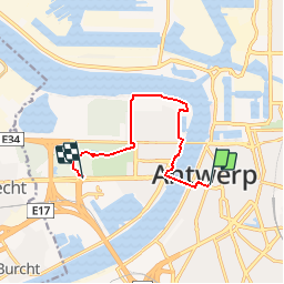
Ruta Senderismo de 7,4 km a descubrir en Flandes, Amberes, Amberes. Esta ruta ha sido propuesta por zorro.
Descripción
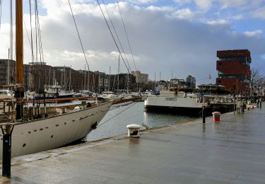
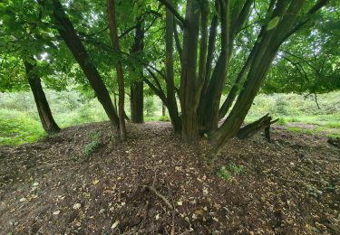
en: wandeling van oud naar nieuwAntwerpen: wandeling van oud naar nieuwMet deze tocht wandel je van het oude centrum naar het nieuwe stadsgebied op de linkeroever. Je vertrekt in de schaduw van de kathedraal op de Groenplaats naar de voetgangerstunnel. Je stapt door de tunnel naar de andere oever, dit is al een attractie op zich. Daarna volg je het wandelpad langs de Schelde naar het flaneergebied van de Antwerpenaar: het Sint-Annastrand met zijn vele eet- en drinkgelegenheden. Vervolgens wandel je door de natuurgebieden Sint-Annabos en Middenvijver naar de tramhalte. Daar heb je keus uit vier tramlijnen om terug naar het beginpunt te sporen.
Localización
Comentarios
Excursiones cerca
![Excursión Senderismo Amberes - Antwerpen-Anvers GR 28 km - Photo](https://media.geolcdn.com/t/375/260/8a9a95ad-e323-46b2-b3a0-a9a22d42126f.jpg&format=jpg&maxdim=2)
![Senderismo Senderismo](https://static1.geolcdn.com/sitytour/trail-icons/101.png)
Senderismo
![](/images/other/stat-length.png)
![](https://static1.geolcdn.com/siteimages/upload/files/16400158638029165_repeat_loop_refresh_sync_direction_icon.png)
![Excursión Coche Amberes - Antwerpen - Photo](https://media.geolcdn.com/t/375/260/e57fdfc8-3d2a-4a8f-99a2-645a42af3d9a.jpg&format=jpg&maxdim=2)
![Coche Coche](https://static1.geolcdn.com/sitytour/trail-icons/401.png)
![Excursión A pie Amberes - Rode paaltjes - Photo](https://media.geolcdn.com/t/375/260/002b9139-fff4-4587-a2ae-858ec5066b90.jpeg&format=jpg&maxdim=2)
![A pie A pie](https://static1.geolcdn.com/sitytour/trail-icons/100.png)
![Excursión sport Amberes - anvers-centre-historique-val-et-oli - Photo](https://media.geolcdn.com/t/375/260/ext.jpg?maxdim=2&url=https%3A%2F%2Fsecurestorage.geolives.com%2Fsitytour%2Ftrail-bg%2Fdefault.jpg)
sport
![](/images/other/stat-length.png)
![](https://static1.geolcdn.com/siteimages/upload/files/16400158638029165_repeat_loop_refresh_sync_direction_icon.png)
![Excursión A pie Zwijndrecht - Beeldenroute Burcht - Photo](https://media.geolcdn.com/t/375/260/030067a1-fb50-4e4b-8c41-4f4e290a4441.jpeg&format=jpg&maxdim=2)
![A pie A pie](https://static1.geolcdn.com/sitytour/trail-icons/100.png)
A pie
![](/images/other/stat-length.png)
![](https://static1.geolcdn.com/siteimages/upload/files/16400158638029165_repeat_loop_refresh_sync_direction_icon.png)
![Excursión Senderismo Amberes - TT - Anvers Downtown - Photo](https://media.geolcdn.com/t/375/260/78c6844e-82d8-476c-93fe-ae421ea9a2e7.jpg&format=jpg&maxdim=2)
![Senderismo Senderismo](https://static1.geolcdn.com/sitytour/trail-icons/101.png)
Senderismo
![](/images/other/stat-length.png)
![](https://static1.geolcdn.com/siteimages/upload/files/16400158638029165_repeat_loop_refresh_sync_direction_icon.png)
![Excursión Senderismo Amberes - Anvers MAS centre et Sud 12 km - Photo](https://media.geolcdn.com/t/375/260/ext.jpg?maxdim=2&url=https%3A%2F%2Fstatic1.geolcdn.com%2Fsiteimages%2Fupload%2Ffiles%2F1553511878bg_sport_marche.png)
![Senderismo Senderismo](https://static1.geolcdn.com/sitytour/trail-icons/101.png)
Senderismo
![](/images/other/stat-length.png)
![](https://static1.geolcdn.com/siteimages/upload/files/16400158638029165_repeat_loop_refresh_sync_direction_icon.png)
![Excursión Senderismo Amberes - refugee walk - Photo](https://media.geolcdn.com/t/375/260/ext.jpg?maxdim=2&url=https%3A%2F%2Fstatic1.geolcdn.com%2Fsiteimages%2Fupload%2Ffiles%2F1553511878bg_sport_marche.png)
![Senderismo Senderismo](https://static1.geolcdn.com/sitytour/trail-icons/101.png)
Senderismo
![](/images/other/stat-length.png)
![](https://static1.geolcdn.com/siteimages/upload/files/16400158638029165_repeat_loop_refresh_sync_direction_icon.png)
![Excursión Senderismo Amberes - ochtend - foto - wandelen - Photo](https://media.geolcdn.com/t/375/260/d2b900ae-0cb6-4d15-bdfe-e0b6ff10b635.jpg&format=jpg&maxdim=2)
![Senderismo Senderismo](https://static1.geolcdn.com/sitytour/trail-icons/101.png)
Senderismo
![](/images/other/stat-length.png)
![](https://static1.geolcdn.com/siteimages/upload/files/16400158638029165_repeat_loop_refresh_sync_direction_icon.png)
7