![](/images/other/stat-length.png)
![Excursión Bicicleta Maaseik - Fietslus Maaseik - Photo](https://media.geolcdn.com/t/1900/400/ext.pjpeg?maxdim=2&url=https%3A%2F%2Fstatic1.geolcdn.com%2Fsiteimages%2Fupload%2Ffiles%2F1524743154velo.jpg)
Fietslus Maaseik
zorro
Usuario
![Longitud](/images/other/stat-length.png)
![Altitud máxima](https://static1.geolcdn.com/siteimages/upload/files/1508320355ic_sort_altitude_max_24dp.png)
![Desnivel positivo](https://static1.geolcdn.com/siteimages/upload/files/1508320355ic_sort_den_pos_24dp.png)
![Km-Effort](/images/other/stat-length.png)
![Altitud mínima](https://static1.geolcdn.com/siteimages/upload/files/1508320355ic_sort_altitude_min_24dp.png)
![Desnivel negativo](https://static1.geolcdn.com/siteimages/upload/files/1508320355ic_sort_den_neg_24dp.png)
![Boucle](https://static1.geolcdn.com/siteimages/upload/files/16400158638029165_repeat_loop_refresh_sync_direction_icon.png)
![Bicicleta](https://static1.geolcdn.com/sitytour/trail-icons/200.png)
1h47
Dificultad : Medio
![Escanee este código QR para abrir la excursión en la aplicación SityTrail](https://capi.geolives.com/qq0zvz2zws4bq2lad0pu/sitytour/trails/250801/qr.png?size=200)
Aplicación GPS de excursión GRATIS
A propósito
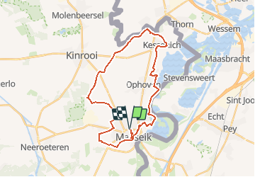
Ruta Bicicleta de 28 km a descubrir en Flandes, Limburgo, Maaseik. Esta ruta ha sido propuesta por zorro.
Descripción
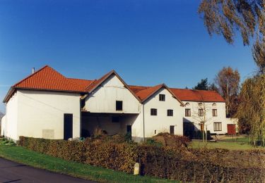
Maaseik is een uitstekende plaats om een verkenning van een stukje Maasland aan te vatten. Na je fietstocht wil je hier beslist een terrasje meepikken, maar de stad heeft ook een brede waaier aan bezienswaardigheden. De stadskern is niet zodanig groot, misschien heb je achteraf nog wel zin in een wandeling. Op het einde van deze fietsroute hebben we onze wandelroute in Maaseik bijgevoegd.
Localización
Comentarios
Excursiones cerca
![Excursión A pie Dilsen-Stokkem - Elen Gele zeshoek - Photo](https://media.geolcdn.com/t/375/260/7dae14a2-afe1-4f71-9fd2-720ade941e16.jpeg&format=jpg&maxdim=2)
![A pie A pie](https://static1.geolcdn.com/sitytour/trail-icons/100.png)
A pie
![](/images/other/stat-length.png)
![](https://static1.geolcdn.com/siteimages/upload/files/16400158638029165_repeat_loop_refresh_sync_direction_icon.png)
![Excursión A pie Dilsen-Stokkem - Elen Oranje bol - Photo](https://media.geolcdn.com/t/375/260/571a30f3-6f71-44a5-99d0-17660bf69f28.jpeg&format=jpg&maxdim=2)
![A pie A pie](https://static1.geolcdn.com/sitytour/trail-icons/100.png)
A pie
![](/images/other/stat-length.png)
![](https://static1.geolcdn.com/siteimages/upload/files/16400158638029165_repeat_loop_refresh_sync_direction_icon.png)
![Excursión A pie Dilsen-Stokkem - Elen Blauwe ruit - Photo](https://media.geolcdn.com/t/375/260/7dae14a2-afe1-4f71-9fd2-720ade941e16.jpeg&format=jpg&maxdim=2)
![A pie A pie](https://static1.geolcdn.com/sitytour/trail-icons/100.png)
A pie
![](/images/other/stat-length.png)
![](https://static1.geolcdn.com/siteimages/upload/files/16400158638029165_repeat_loop_refresh_sync_direction_icon.png)
![Excursión A pie Dilsen-Stokkem - Elen Groene rechthoek - Photo](https://media.geolcdn.com/t/375/260/7dae14a2-afe1-4f71-9fd2-720ade941e16.jpeg&format=jpg&maxdim=2)
![A pie A pie](https://static1.geolcdn.com/sitytour/trail-icons/100.png)
A pie
![](/images/other/stat-length.png)
![](https://static1.geolcdn.com/siteimages/upload/files/16400158638029165_repeat_loop_refresh_sync_direction_icon.png)
![Excursión A pie Maaseik - Tösch-Langeren Rode driehoek - Photo](https://media.geolcdn.com/t/375/260/9126700f-aede-4565-89c6-8d67eeb4d07b.jpeg&format=jpg&maxdim=2)
![A pie A pie](https://static1.geolcdn.com/sitytour/trail-icons/100.png)
A pie
![](/images/other/stat-length.png)
![](https://static1.geolcdn.com/siteimages/upload/files/16400158638029165_repeat_loop_refresh_sync_direction_icon.png)
![Excursión A pie Maaseik - Tösch-Langeren Oranje bol - Photo](https://media.geolcdn.com/t/375/260/9126700f-aede-4565-89c6-8d67eeb4d07b.jpeg&format=jpg&maxdim=2)
![A pie A pie](https://static1.geolcdn.com/sitytour/trail-icons/100.png)
A pie
![](/images/other/stat-length.png)
![](https://static1.geolcdn.com/siteimages/upload/files/16400158638029165_repeat_loop_refresh_sync_direction_icon.png)
![Excursión A pie Maaseik - Tösch-Langeren Blauwe ruit - Photo](https://media.geolcdn.com/t/375/260/85ce57bf-cef0-4d03-8455-4e3cc1ff99d1.jpeg&format=jpg&maxdim=2)
![A pie A pie](https://static1.geolcdn.com/sitytour/trail-icons/100.png)
A pie
![](/images/other/stat-length.png)
![](https://static1.geolcdn.com/siteimages/upload/files/16400158638029165_repeat_loop_refresh_sync_direction_icon.png)
![Excursión A pie Maaseik - Tösch-Langeren Gele zeshoek - Photo](https://media.geolcdn.com/t/375/260/85ce57bf-cef0-4d03-8455-4e3cc1ff99d1.jpeg&format=jpg&maxdim=2)
![A pie A pie](https://static1.geolcdn.com/sitytour/trail-icons/100.png)
A pie
![](/images/other/stat-length.png)
![](https://static1.geolcdn.com/siteimages/upload/files/16400158638029165_repeat_loop_refresh_sync_direction_icon.png)
![Excursión A pie Maaseik - Aldeneik & Maaseik Rode driehoek - Photo](https://media.geolcdn.com/t/375/260/4688143a-7d56-4795-b08e-4930e8771c1e.jpeg&format=jpg&maxdim=2)
![A pie A pie](https://static1.geolcdn.com/sitytour/trail-icons/100.png)
A pie
![](/images/other/stat-length.png)
![](https://static1.geolcdn.com/siteimages/upload/files/16400158638029165_repeat_loop_refresh_sync_direction_icon.png)