![](/images/other/stat-length.png)
![Excursión Senderismo Lozzi - Refuge du monte cinto - Photo](https://media.geolcdn.com/t/1900/400/ext.pjpeg?maxdim=2&url=https%3A%2F%2Fstatic1.geolcdn.com%2Fsiteimages%2Fupload%2Ffiles%2F1553511878bg_sport_marche.png)
Refuge du monte cinto
jps13
Usuario
![Longitud](/images/other/stat-length.png)
Longitud
11,4 km
![Altitud máxima](https://static1.geolcdn.com/siteimages/upload/files/1508320355ic_sort_altitude_max_24dp.png)
Altitud máxima
1719 m
![Desnivel positivo](https://static1.geolcdn.com/siteimages/upload/files/1508320355ic_sort_den_pos_24dp.png)
Desnivel positivo
683 m
![Km-Effort](/images/other/stat-length.png)
Km-Effort
21 km
![Altitud mínima](https://static1.geolcdn.com/siteimages/upload/files/1508320355ic_sort_altitude_min_24dp.png)
Altitud mínima
1071 m
![Desnivel negativo](https://static1.geolcdn.com/siteimages/upload/files/1508320355ic_sort_den_neg_24dp.png)
Desnivel negativo
681 m
![Boucle](https://static1.geolcdn.com/siteimages/upload/files/16400158638029165_repeat_loop_refresh_sync_direction_icon.png)
Boucle
Sí
Fecha de creación :
2020-08-07 12:45:52.0
Última modificación :
2020-08-07 16:44:40.71
![Senderismo](https://static1.geolcdn.com/sitytour/trail-icons/101.png)
3h25
Dificultad : Fácil
![Escanee este código QR para abrir la excursión en la aplicación SityTrail](https://capi.geolives.com/qq0zvz2zws4bq2lad0pu/sitytour/trails/2506081/qr.png?size=200)
Aplicación GPS de excursión GRATIS
A propósito
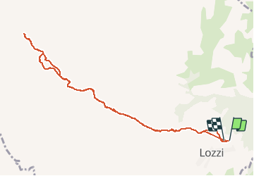
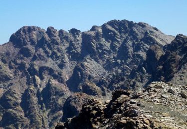
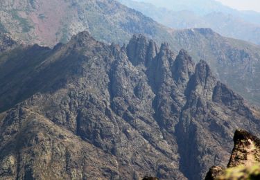
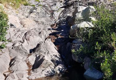
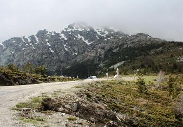
Ruta Senderismo de 11,4 km a descubrir en Córcega, Alta Córcega, Lozzi. Esta ruta ha sido propuesta por jps13.
Descripción
Pas difficile mais longue montée à l’aller et longue descente au retour, parmi les vaches, veaux, chèvres, chevaux.
Localización
País:
France
Región :
Córcega
Departamento/provincia :
Alta Córcega
Municipio :
Lozzi
Localidad:
Unknown
Salida:(Dec)
Salida:(UTM)
500854 ; 4688487 (32T) N.
Comentarios
Excursiones cerca
![Excursión Senderismo Corscia - Trek de Corscia à Castiglione en 4 jours - Photo](https://media.geolcdn.com/t/375/260/ext.jpg?maxdim=2&url=https%3A%2F%2Fservices.sitytrail.com%2FGeolivesWS%2FDownloadMedia.ashx%3FTrailID%3D118879%26Media%3D13101_6.jpg)
![Senderismo Senderismo](https://static1.geolcdn.com/sitytour/trail-icons/101.png)
Trek de Corscia à Castiglione en 4 jours
Senderismo
Muy difícil
(1)
Corscia,
Córcega,
Alta Córcega,
France
![](/images/other/stat-length.png)
31 km | 67 km-effort
30h 0min
![](https://static1.geolcdn.com/siteimages/upload/files/16400158638029165_repeat_loop_refresh_sync_direction_icon.png)
No
![Excursión Senderismo Lozzi - boucle monte Cinto côté sud - Photo](https://media.geolcdn.com/t/375/260/ext.jpg?maxdim=2&url=https%3A%2F%2Fservices.sitytrail.com%2FGeolivesWS%2FDownloadMedia.ashx%3FTrailID%3D1047002%26Media%3Dfix__20180926124643.jpg)
![Senderismo Senderismo](https://static1.geolcdn.com/sitytour/trail-icons/101.png)
boucle monte Cinto côté sud
Senderismo
Difícil
Lozzi,
Córcega,
Alta Córcega,
France
![](/images/other/stat-length.png)
18,8 km | 41 km-effort
8h 22min
![](https://static1.geolcdn.com/siteimages/upload/files/16400158638029165_repeat_loop_refresh_sync_direction_icon.png)
Sí
![Excursión Otra actividad Albertacce - Tour des Cinque Fratti - Photo](https://media.geolcdn.com/t/375/260/ext.jpg?maxdim=2&url=https%3A%2F%2Fservices.sitytrail.com%2FGeolivesWS%2FDownloadMedia.ashx%3FTrailID%3D976371%26Media%3Dfix__20180529135617.jpg)
![Otra actividad Otra actividad](https://static1.geolcdn.com/sitytour/trail-icons/900.png)
Tour des Cinque Fratti
Otra actividad
Muy fácil
Albertacce,
Córcega,
Alta Córcega,
France
![](/images/other/stat-length.png)
12,3 km | 24 km-effort
5h 36min
![](https://static1.geolcdn.com/siteimages/upload/files/16400158638029165_repeat_loop_refresh_sync_direction_icon.png)
Sí
![Excursión Senderismo Corscia - Verdatu et Biancu - Trek de 4 jours - Photo](https://media.geolcdn.com/t/375/260/ext.jpg?maxdim=2&url=https%3A%2F%2Fservices.sitytrail.com%2FGeolivesWS%2FDownloadMedia.ashx%3FTrailID%3D317081%26Media%3D16227_6.jpg)
![Senderismo Senderismo](https://static1.geolcdn.com/sitytour/trail-icons/101.png)
Verdatu et Biancu - Trek de 4 jours
Senderismo
Difícil
Corscia,
Córcega,
Alta Córcega,
France
![](/images/other/stat-length.png)
32 km | 70 km-effort
75h 0min
![](https://static1.geolcdn.com/siteimages/upload/files/16400158638029165_repeat_loop_refresh_sync_direction_icon.png)
Sí
![Excursión Senderismo Albertacce - Monte Albanu - Calasima - Photo](https://media.geolcdn.com/t/375/260/ext.jpg?maxdim=2&url=https%3A%2F%2Fservices.sitytrail.com%2FGeolivesWS%2FDownloadMedia.ashx%3FTrailID%3D316908%26Media%3D16006_6.jpg)
![Senderismo Senderismo](https://static1.geolcdn.com/sitytour/trail-icons/101.png)
Monte Albanu - Calasima
Senderismo
Medio
Albertacce,
Córcega,
Alta Córcega,
France
![](/images/other/stat-length.png)
12,5 km | 25 km-effort
7h 30min
![](https://static1.geolcdn.com/siteimages/upload/files/16400158638029165_repeat_loop_refresh_sync_direction_icon.png)
Sí
![Excursión Senderismo Albertacce - GR20 Etape 4bis Calisima Bergerie de Ballone - Photo](https://media.geolcdn.com/t/375/260/ext.jpg?maxdim=2&url=https%3A%2F%2Fstatic1.geolcdn.com%2Fsiteimages%2Fupload%2Ffiles%2F1553511878bg_sport_marche.png)
![Senderismo Senderismo](https://static1.geolcdn.com/sitytour/trail-icons/101.png)
GR20 Etape 4bis Calisima Bergerie de Ballone
Senderismo
Fácil
Albertacce,
Córcega,
Alta Córcega,
France
![](/images/other/stat-length.png)
6,3 km | 10,4 km-effort
1h 45min
![](https://static1.geolcdn.com/siteimages/upload/files/16400158638029165_repeat_loop_refresh_sync_direction_icon.png)
No
![Excursión Senderismo Albertacce - mont albanu - Photo](https://media.geolcdn.com/t/375/260/5aaae86d-d200-4210-abe6-549d30533162.jpg&format=jpg&maxdim=2)
![Senderismo Senderismo](https://static1.geolcdn.com/sitytour/trail-icons/101.png)
mont albanu
Senderismo
Muy fácil
Albertacce,
Córcega,
Alta Córcega,
France
![](/images/other/stat-length.png)
16 km | 29 km-effort
7h 15min
![](https://static1.geolcdn.com/siteimages/upload/files/16400158638029165_repeat_loop_refresh_sync_direction_icon.png)
Sí
![Excursión Senderismo Albertacce - GR® de Corse - Mare a Mare Nord - De Albertacce à Verghju - Photo](https://media.geolcdn.com/t/375/260/ext.jpg?maxdim=2&url=https%3A%2F%2Fservices.sitytrail.com%2FGeolivesWS%2FDownloadMedia.ashx%3FTrailID%3D316791%26Media%3D5483_1.jpg)
![Senderismo Senderismo](https://static1.geolcdn.com/sitytour/trail-icons/101.png)
GR® de Corse - Mare a Mare Nord - De Albertacce à Verghju
Senderismo
Difícil
Albertacce,
Córcega,
Alta Córcega,
France
![](/images/other/stat-length.png)
12,1 km | 21 km-effort
4h 30min
![](https://static1.geolcdn.com/siteimages/upload/files/16400158638029165_repeat_loop_refresh_sync_direction_icon.png)
No
![Excursión Motor Calacuccia - cap Corse - Photo](https://media.geolcdn.com/t/375/260/ext.jpg?maxdim=2&url=https%3A%2F%2Fservices.sitytrail.com%2FGeolivesWS%2FDownloadMedia.ashx%3FTrailID%3D153172%26Media%3D20120911130956.jpeg)
![Motor Motor](https://static1.geolcdn.com/sitytour/trail-icons/400.png)