![](/images/other/stat-length.png)
mullerthal-2- 9.7 km (102)
zepp63
Usuario
![Longitud](/images/other/stat-length.png)
Longitud
9,7 km
![Altitud máxima](https://static1.geolcdn.com/siteimages/upload/files/1508320355ic_sort_altitude_max_24dp.png)
Altitud máxima
352 m
![Desnivel positivo](https://static1.geolcdn.com/siteimages/upload/files/1508320355ic_sort_den_pos_24dp.png)
Desnivel positivo
282 m
![Km-Effort](/images/other/stat-length.png)
Km-Effort
13,4 km
![Altitud mínima](https://static1.geolcdn.com/siteimages/upload/files/1508320355ic_sort_altitude_min_24dp.png)
Altitud mínima
211 m
![Desnivel negativo](https://static1.geolcdn.com/siteimages/upload/files/1508320355ic_sort_den_neg_24dp.png)
Desnivel negativo
282 m
![Boucle](https://static1.geolcdn.com/siteimages/upload/files/16400158638029165_repeat_loop_refresh_sync_direction_icon.png)
Boucle
Sí
Fecha de creación :
2020-08-04 20:55:29.973
Última modificación :
2020-08-17 19:11:58.424
![A pie](https://static1.geolcdn.com/sitytour/trail-icons/100.png)
--
Dificultad : Medio
![Escanee este código QR para abrir la excursión en la aplicación SityTrail](https://capi.geolives.com/qq0zvz2zws4bq2lad0pu/sitytour/trails/2502569/qr.png?size=200)
Aplicación GPS de excursión GRATIS
A propósito
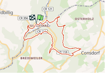
Ruta A pie de 9,7 km a descubrir en Desconocido, Canton Echternach, Waldbillig. Esta ruta ha sido propuesta por zepp63.
Descripción
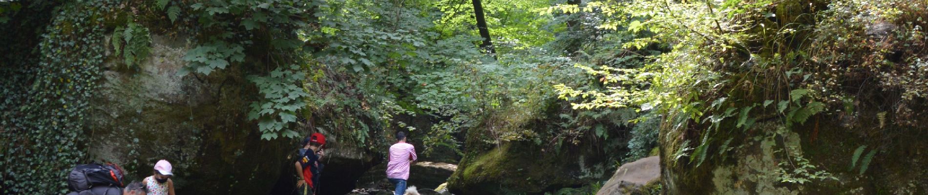
Magnifique rando au départ du parking du camping, vers la cascade, puis parcours dans les bois superbe, dépaysement garanti
Localización
País:
Luxembourg
Región :
Desconocido
Departamento/provincia :
Canton Echternach
Municipio :
Waldbillig
Localidad:
Unknown
Salida:(Dec)
Salida:(UTM)
306130 ; 5518849 (32U) N.
Comentarios
Excursiones cerca
![Excursión Senderismo Waldbillig - 2024-08-10_15h10m00_Sentier_local_-_W4 - Photo](https://media.geolcdn.com/t/375/260/d315698e-faa8-4cbd-932a-8a7221249730.jpg&format=jpg&maxdim=2)
![Senderismo Senderismo](https://static1.geolcdn.com/sitytour/trail-icons/101.png)
2024-08-10_15h10m00_Sentier_local_-_W4
Senderismo
Medio
(1)
Waldbillig,
Desconocido,
Canton Echternach,
Luxembourg
![](/images/other/stat-length.png)
6,2 km | 7,8 km-effort
1h 45min
![](https://static1.geolcdn.com/siteimages/upload/files/16400158638029165_repeat_loop_refresh_sync_direction_icon.png)
Sí
![Excursión Senderismo Consdorf - 2023-06-19_09h33m43_Sentier_local_-_C6 - Photo](https://media.geolcdn.com/t/375/260/1a93b691-9fc1-4ff8-ae1a-57fcf6e1418e.jpg&format=jpg&maxdim=2)
![Senderismo Senderismo](https://static1.geolcdn.com/sitytour/trail-icons/101.png)
2023-06-19_09h33m43_Sentier_local_-_C6
Senderismo
Medio
(1)
Consdorf,
Desconocido,
Canton Echternach,
Luxembourg
![](/images/other/stat-length.png)
5,8 km | 7,3 km-effort
1h 39min
![](https://static1.geolcdn.com/siteimages/upload/files/16400158638029165_repeat_loop_refresh_sync_direction_icon.png)
Sí
![Excursión Senderismo Consdorf - 2023-06-13_20h43m48_Sentier_local_-_C2 - Photo](https://media.geolcdn.com/t/375/260/0cc79ac2-8683-4672-970a-cfe76e408507.jpg&format=jpg&maxdim=2)
![Senderismo Senderismo](https://static1.geolcdn.com/sitytour/trail-icons/101.png)
2023-06-13_20h43m48_Sentier_local_-_C2
Senderismo
Fácil
(1)
Consdorf,
Desconocido,
Canton Echternach,
Luxembourg
![](/images/other/stat-length.png)
4,2 km | 5,5 km-effort
1h 15min
![](https://static1.geolcdn.com/siteimages/upload/files/16400158638029165_repeat_loop_refresh_sync_direction_icon.png)
Sí
![Excursión Senderismo Consdorf - 2023-06-13_20h03m09_Circuit_auto-pdestre_Consdorf_-_Mullerthal - Photo](https://media.geolcdn.com/t/375/260/43e83e22-9e28-4a45-bf58-3588aa9e8a2f.jpg&format=jpg&maxdim=2)
![Senderismo Senderismo](https://static1.geolcdn.com/sitytour/trail-icons/101.png)
2023-06-13_20h03m09_Circuit_auto-pdestre_Consdorf_-_Mullerthal
Senderismo
Medio
(2)
Consdorf,
Desconocido,
Canton Echternach,
Luxembourg
![](/images/other/stat-length.png)
9 km | 12,3 km-effort
2h 48min
![](https://static1.geolcdn.com/siteimages/upload/files/16400158638029165_repeat_loop_refresh_sync_direction_icon.png)
Sí
![Excursión Senderismo Berdorf - Berdorf - B2 - Müllerthal - Photo](https://media.geolcdn.com/t/375/260/517daf86-eb8b-412e-9a7e-d0a346807e81.jpg&format=jpg&maxdim=2)
![Senderismo Senderismo](https://static1.geolcdn.com/sitytour/trail-icons/101.png)
Berdorf - B2 - Müllerthal
Senderismo
Medio
(2)
Berdorf,
Desconocido,
Canton Echternach,
Luxembourg
![](/images/other/stat-length.png)
6,7 km | 8,5 km-effort
1h 35min
![](https://static1.geolcdn.com/siteimages/upload/files/16400158638029165_repeat_loop_refresh_sync_direction_icon.png)
Sí
![Excursión Senderismo Beaufort - 2021-07-05_20h10m00_gpx-file (1) - Photo](https://media.geolcdn.com/t/375/260/9b40ebf8-55f0-408d-8504-76ef1490c879.jpg&format=jpg&maxdim=2)
![Senderismo Senderismo](https://static1.geolcdn.com/sitytour/trail-icons/101.png)
2021-07-05_20h10m00_gpx-file (1)
Senderismo
Medio
(1)
Beaufort,
Desconocido,
Canton Echternach,
Luxembourg
![](/images/other/stat-length.png)
10,6 km | 13,6 km-effort
3h 5min
![](https://static1.geolcdn.com/siteimages/upload/files/16400158638029165_repeat_loop_refresh_sync_direction_icon.png)
Sí
![Excursión Senderismo Waldbillig - Mullerthal randonnée magnifique - Photo](https://media.geolcdn.com/t/375/260/3f58fb00-23e0-4e5f-be44-94a05c44c601.jpg&format=jpg&maxdim=2)
![Senderismo Senderismo](https://static1.geolcdn.com/sitytour/trail-icons/101.png)
Mullerthal randonnée magnifique
Senderismo
Difícil
(4)
Waldbillig,
Desconocido,
Canton Echternach,
Luxembourg
![](/images/other/stat-length.png)
9,3 km | 12,9 km-effort
4h 21min
![](https://static1.geolcdn.com/siteimages/upload/files/16400158638029165_repeat_loop_refresh_sync_direction_icon.png)
Sí
![Excursión Senderismo Consdorf - 2023-06-21_17h04m10_Sentier_local_-_C1 (1) - Photo](https://media.geolcdn.com/t/375/260/67bec963-192a-46c1-a89d-070dac0d9ebc.jpg&format=jpg&maxdim=2)
![Senderismo Senderismo](https://static1.geolcdn.com/sitytour/trail-icons/101.png)
2023-06-21_17h04m10_Sentier_local_-_C1 (1)
Senderismo
Fácil
(1)
Consdorf,
Desconocido,
Canton Echternach,
Luxembourg
![](/images/other/stat-length.png)
1,9 km | 2,5 km-effort
34min
![](https://static1.geolcdn.com/siteimages/upload/files/16400158638029165_repeat_loop_refresh_sync_direction_icon.png)
Sí
![Excursión Senderismo Berdorf - 2023-06-03_18h17m36_Sentier_local_-_B8 - Photo](https://media.geolcdn.com/t/375/260/7a8870ac-d558-4a39-b7c2-bdeb26e936c0.jpg&format=jpg&maxdim=2)
![Senderismo Senderismo](https://static1.geolcdn.com/sitytour/trail-icons/101.png)
2023-06-03_18h17m36_Sentier_local_-_B8
Senderismo
Medio
(2)
Berdorf,
Desconocido,
Canton Echternach,
Luxembourg
![](/images/other/stat-length.png)
11,7 km | 15 km-effort
3h 24min
![](https://static1.geolcdn.com/siteimages/upload/files/16400158638029165_repeat_loop_refresh_sync_direction_icon.png)
Sí