![](/images/other/stat-length.png)
![Excursión Senderismo Saint-Genès-Champanelle - puy de labassol, puy de la vache depuis la cassièrre - Photo](https://media.geolcdn.com/t/1900/400/a88ca871-1b9b-4673-b3ac-d96acb1fd5fd.jpg&format=pjpeg&maxdim=2)
puy de labassol, puy de la vache depuis la cassièrre
fbienmuller
Usuario
![Longitud](/images/other/stat-length.png)
Longitud
13,5 km
![Altitud máxima](https://static1.geolcdn.com/siteimages/upload/files/1508320355ic_sort_altitude_max_24dp.png)
Altitud máxima
1174 m
![Desnivel positivo](https://static1.geolcdn.com/siteimages/upload/files/1508320355ic_sort_den_pos_24dp.png)
Desnivel positivo
430 m
![Km-Effort](/images/other/stat-length.png)
Km-Effort
19,3 km
![Altitud mínima](https://static1.geolcdn.com/siteimages/upload/files/1508320355ic_sort_altitude_min_24dp.png)
Altitud mínima
842 m
![Desnivel negativo](https://static1.geolcdn.com/siteimages/upload/files/1508320355ic_sort_den_neg_24dp.png)
Desnivel negativo
432 m
![Boucle](https://static1.geolcdn.com/siteimages/upload/files/16400158638029165_repeat_loop_refresh_sync_direction_icon.png)
Boucle
Sí
Fecha de creación :
2020-08-04 08:00:49.285
Última modificación :
2020-08-04 12:27:03.559
![Senderismo](https://static1.geolcdn.com/sitytour/trail-icons/101.png)
3h48
Dificultad : Medio
![Escanee este código QR para abrir la excursión en la aplicación SityTrail](https://capi.geolives.com/qq0zvz2zws4bq2lad0pu/sitytour/trails/2501812/qr.png?size=200)
Aplicación GPS de excursión GRATIS
A propósito
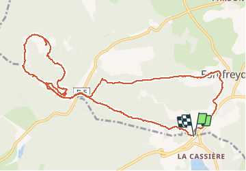
Ruta Senderismo de 13,5 km a descubrir en Auvergne-Rhône-Alpes, Puy-de-Dôme, Saint-Genès-Champanelle. Esta ruta ha sido propuesta por fbienmuller.
Descripción
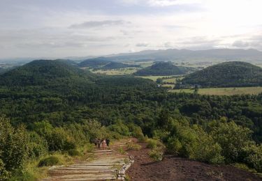
Randonnée très sympa. Si les gens préfèrent les escaliers, il faut débuter par le puy de la vache...
Localización
País:
France
Región :
Auvergne-Rhône-Alpes
Departamento/provincia :
Puy-de-Dôme
Municipio :
Saint-Genès-Champanelle
Localidad:
Unknown
Salida:(Dec)
Salida:(UTM)
499676 ; 5060068 (31T) N.
Comentarios
Excursiones cerca
![Excursión Senderismo Aydat - LacAydatVeyreras_T - Photo](https://media.geolcdn.com/t/375/260/ext.jpg?maxdim=2&url=https%3A%2F%2Fservices.sitytrail.com%2FGeolivesWS%2FDownloadMedia.ashx%3FTrailID%3D844478%26Media%3Dfix__20171012174546.jpg)
![Senderismo Senderismo](https://static1.geolcdn.com/sitytour/trail-icons/101.png)
LacAydatVeyreras_T
Senderismo
Muy fácil
(1)
Aydat,
Auvergne-Rhône-Alpes,
Puy-de-Dôme,
France
![](/images/other/stat-length.png)
11,1 km | 14,2 km-effort
3h 6min
![](https://static1.geolcdn.com/siteimages/upload/files/16400158638029165_repeat_loop_refresh_sync_direction_icon.png)
Sí
![Excursión Senderismo Aydat - Lassolas-La Vache-Vichatel - Photo](https://media.geolcdn.com/t/375/260/ext.jpg?maxdim=2&url=https%3A%2F%2Fservices.sitytrail.com%2FGeolivesWS%2FDownloadMedia.ashx%3FTrailID%3D602562%26Media%3Dfix__20160723172634.jpg)
![Senderismo Senderismo](https://static1.geolcdn.com/sitytour/trail-icons/101.png)
Lassolas-La Vache-Vichatel
Senderismo
Medio
(1)
Aydat,
Auvergne-Rhône-Alpes,
Puy-de-Dôme,
France
![](/images/other/stat-length.png)
13,2 km | 18,6 km-effort
4h 4min
![](https://static1.geolcdn.com/siteimages/upload/files/16400158638029165_repeat_loop_refresh_sync_direction_icon.png)
Sí
![Excursión Senderismo Aydat - Aydat_Montjuger_ST - Photo](https://media.geolcdn.com/t/375/260/c2caf5c0-1fa1-4013-81dc-2ab6f7f92569.jpg&format=jpg&maxdim=2)
![Senderismo Senderismo](https://static1.geolcdn.com/sitytour/trail-icons/101.png)
Aydat_Montjuger_ST
Senderismo
Fácil
(1)
Aydat,
Auvergne-Rhône-Alpes,
Puy-de-Dôme,
France
![](/images/other/stat-length.png)
10,5 km | 12,7 km-effort
3h 0min
![](https://static1.geolcdn.com/siteimages/upload/files/16400158638029165_repeat_loop_refresh_sync_direction_icon.png)
Sí
![Excursión Senderismo Aydat - Aydat_Puy_Rodde - Photo](https://media.geolcdn.com/t/375/260/8eea2914-ded8-4558-a06b-e7583efcbd98.jpg&format=jpg&maxdim=2)
![Senderismo Senderismo](https://static1.geolcdn.com/sitytour/trail-icons/101.png)
Aydat_Puy_Rodde
Senderismo
Medio
(1)
Aydat,
Auvergne-Rhône-Alpes,
Puy-de-Dôme,
France
![](/images/other/stat-length.png)
10,5 km | 13,6 km-effort
3h 15min
![](https://static1.geolcdn.com/siteimages/upload/files/16400158638029165_repeat_loop_refresh_sync_direction_icon.png)
Sí
![Senderismo Senderismo](https://static1.geolcdn.com/sitytour/trail-icons/101.png)
puy de Vichatel
Senderismo
Muy fácil
(1)
Aydat,
Auvergne-Rhône-Alpes,
Puy-de-Dôme,
France
![](/images/other/stat-length.png)
3,8 km | 5,8 km-effort
1h 13min
![](https://static1.geolcdn.com/siteimages/upload/files/16400158638029165_repeat_loop_refresh_sync_direction_icon.png)
Sí
![Excursión A pie Aydat - Les Cheires Hautes - Photo](https://media.geolcdn.com/t/375/260/8868eef4-2c9a-4cff-b569-164b10942dc4.jpeg&format=jpg&maxdim=2)
![A pie A pie](https://static1.geolcdn.com/sitytour/trail-icons/100.png)
Les Cheires Hautes
A pie
Fácil
Aydat,
Auvergne-Rhône-Alpes,
Puy-de-Dôme,
France
![](/images/other/stat-length.png)
15,9 km | 20 km-effort
4h 32min
![](https://static1.geolcdn.com/siteimages/upload/files/16400158638029165_repeat_loop_refresh_sync_direction_icon.png)
Sí
![Excursión A pie Aydat - Le Lac de la Cassière - Photo](https://media.geolcdn.com/t/375/260/d570a0c9-091c-4e7e-92f0-ef1a2bdb50c5.jpeg&format=jpg&maxdim=2)
![A pie A pie](https://static1.geolcdn.com/sitytour/trail-icons/100.png)
Le Lac de la Cassière
A pie
Fácil
Aydat,
Auvergne-Rhône-Alpes,
Puy-de-Dôme,
France
![](/images/other/stat-length.png)
3,2 km | 4 km-effort
54min
![](https://static1.geolcdn.com/siteimages/upload/files/16400158638029165_repeat_loop_refresh_sync_direction_icon.png)
Sí
![Excursión A pie Saint-Genès-Champanelle - Nadaillat - Photo](https://media.geolcdn.com/t/375/260/f63239da-1e27-43d7-84c3-ba50289c6d9e.jpeg&format=jpg&maxdim=2)
![A pie A pie](https://static1.geolcdn.com/sitytour/trail-icons/100.png)
Nadaillat
A pie
Fácil
Saint-Genès-Champanelle,
Auvergne-Rhône-Alpes,
Puy-de-Dôme,
France
![](/images/other/stat-length.png)
6,6 km | 9,3 km-effort
2h 7min
![](https://static1.geolcdn.com/siteimages/upload/files/16400158638029165_repeat_loop_refresh_sync_direction_icon.png)
Sí
![Excursión A pie Aydat - Le Puy de Vichatel - Photo](https://media.geolcdn.com/t/375/260/393a6927-23db-4d99-8cc9-f6649fdba949.jpeg&format=jpg&maxdim=2)
![A pie A pie](https://static1.geolcdn.com/sitytour/trail-icons/100.png)
Le Puy de Vichatel
A pie
Fácil
Aydat,
Auvergne-Rhône-Alpes,
Puy-de-Dôme,
France
![](/images/other/stat-length.png)
8,1 km | 10,5 km-effort
2h 22min
![](https://static1.geolcdn.com/siteimages/upload/files/16400158638029165_repeat_loop_refresh_sync_direction_icon.png)
Sí